| WPC Met Watch |
|
|
Mesoscale Precipitation Discussion: #0199 |
|
(Issued at 1255 AM EDT Mon Apr 29 2024
) |
|
| MPD Selection |
|
|
|
|
|

Mesoscale Precipitation Discussion 0199
NWS Weather Prediction Center College Park MD
1255 AM EDT Mon Apr 29 2024

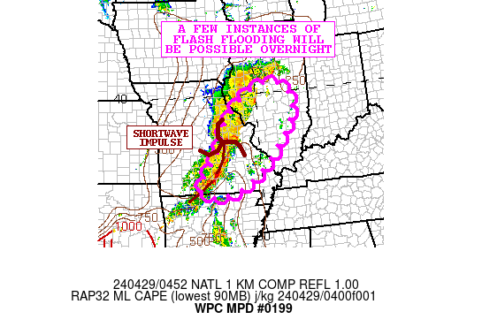
Areas affected...Portions of Central/Southern MO into
Central/Southern IL

Concerning...Heavy rainfall...Flash flooding possible

Valid 290455Z - 291055Z

SUMMARY...A broken band of showers and thunderstorms continues to
advance northeastward across the middle MS Valley. Given
relatively wet antecedent conditions and locally heavy rainfall
rates, a few instances of flash flooding will be possible
overnight.

DISCUSSION...A shortwave impulse continues to advance
northeastward through the middle MS Valley which is interacting
with a nose of at least modest instability and shear for a broken
axis of locally heavy showers and thunderstorms.

The southwest flank of the vort center over central MO is
currently the most convectively active region and where the
heaviest rainfall rates are focused.  A low-level jet of 40 kts is
driving a corridor of stronger moisture convergence and this
coupled with MLCAPE values of as much as 500 to 1000 J/kg are
helping to yield rainfall rates occasionally of 1 to 1.5
inches/hour. A belt of 30 to 40+ kt effective bulk shear values
are helping to favor a persistent degree of organization with some
of the convection too despite instability being relatively modest.

This shortwave energy should advance through eastern MO and
gradually into central/southern IL later in the night, but there
will likely be a continuation of at least broken bands of
convection given the level of moisture convergence/forcing and
lingering instability. The activity will also tend to be aligned
in a southwest/northeast fashion with the deeper layer steering
flow, and therefore there may be some cell-training that occurs.

The antecedent conditions over the region are relatively wet, and
with the potential for locally an additional 2 to 3 inches of rain
overnight, there may be a few instances of flash flooding.

Orrison

ATTN...WFO...ILX...LSX...LZK...PAH...SGF...

ATTN...RFC...LMRFC...MBRFC...NCRFC...OHRFC...NWC...

LAT...LON   40328909 39848835 39138844 38488883 37488967
            36689076 36399174 36439257 36879273 37929197
            39129138 40089024
Download in GIS format: Shapefile
| KML
Last Updated: 1255 AM EDT Mon Apr 29 2024
|


