| WPC Met Watch |
|
|
Mesoscale Precipitation Discussion: #0200 |
|
(Issued at 340 AM EDT Mon Apr 29 2024
) |
|
| MPD Selection |
|
|
|
|
|

Mesoscale Precipitation Discussion 0200
NWS Weather Prediction Center College Park MD
340 AM EDT Mon Apr 29 2024

Areas affected...Southeast TX...Central to Southwest LA...Far
Southwest MS

Concerning...Heavy rainfall...Flash flooding likely

Valid 290740Z - 291340Z

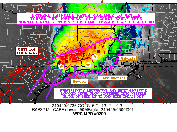
SUMMARY...Slow-moving and locally training showers and
thunderstorms with extreme rainfall rates continue to impact
southeast TX and areas of central to southwest LA. Flash flooding
continues to be a major concern early this morning, and multiple
major metropolitan areas including Houston and Lake Charles and
their suburbs may see significant and life-threatening impacts as
extreme rainfall advances toward the Gulf Coast.

DISCUSSION...A long-lived, slow-moving, and high-impact MCS
continues to gradually edge down to the southeast toward the Gulf
Coast early this morning with extreme rainfall rates. The GOES-E
IR satellite imagery continues to depict a very impressive cloud
pattern with very cold overshooting convective tops (occasionally
to -80C) with a strongly divergent and wedged signature aloft.

Radar imagery shows the eastern flank of the MCS involving central
LA making a bit more progress in advancing down to the southeast
as a cold pool becomes better established, but unfortunately this
has not been the case for many areas in southeast TX to the north
and northeast of Houston where the western and southwest flanks of
the convective line have exhibited only a slow and gradual push
down to the southeast, with considerable cell-training and
persistence of extreme rainfall rates. This has resulted in
significant flash flooding overnight for a number of locations.
Over the last hour, some of these extreme rainfall rates have
begun to also edge into southwest LA to the north and northwest of
Lake Charles as the convective line increasingly becomes aligned
in a west to east fashion.

The convection remains well-established along the leading edge of
an outflow boundary with moderate to strong instability pooled
along it which is being aided by persistently convergent and very
moist low to mid-level southwest flow. MLCAPE values are still on
the order of 1500 to 2500 J/kg with PWs of around 1.75 inches, and
this is facilitating extremely heavy rainfall rates of as much as
2 to 3 inches/hour.

Overall, the environment remains conducive for this long-lived MCS
to persist through the early morning hours given the level of
divergent flow aloft and persistent moisture/instability
transport, and this will maintain the threat for significant
rainfall totals and corresponding concerns for flash flooding.

Gradually a sufficient cold pool should develop to help advance
the heaviest rains offshore into the northwest Gulf of Mexico by
mid-morning, but until then, areas of southeast TX and southwest
LA along a line from Houston to Lake Charles and especially the
northern suburbs of these metropolitan areas should see several
inches of rain. The most recent HRRR guidance and the 00Z HREF
consensus suggest additional totals of 3 to 6 inches with isolated
heavier amounts. Consequently, more flash flooding is likely, some
of which may be significant and life-threatening.

Orrison

ATTN...WFO...EWX...HGX...JAN...LCH...LIX...SHV...

ATTN...RFC...LMRFC...WGRFC...NWC...

LAT...LON   32119105 30979080 29819183 29589333 29439455
            28909531 28649611 29059661 29889648 30499587
            30999478 31389314 31949209
Download in GIS format: Shapefile
| KML
Last Updated: 340 AM EDT Mon Apr 29 2024
|


