| WPC Met Watch |
|
|
Mesoscale Precipitation Discussion: #0248 |
|
(Issued at 945 AM EDT Thu May 09 2024
) |
|
| MPD Selection |
|
|
|
|
|

Mesoscale Precipitation Discussion 0248
NWS Weather Prediction Center College Park MD
945 AM EDT Thu May 09 2024

Areas affected...portions of northern/central AL/GA into western
SC

Concerning...Heavy rainfall...Flash flooding likely

Valid 091345Z - 091800Z

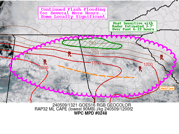
Summary...Continued flash flooding expected for several more
hours, some locally significant where as much as 3-7" of rainfall
occurred overnight.

Discussion...A pair of MCSs (mesoscale convective systems) from
overnight remain active this morning across portions of the
Southeast (focused mainly from central/northern AL/GA into
portions of western SC) with scattered to numerous areas of
flooding (some significant) still ongoing this morning. Convection
has gradually weakened over the past several hours, while also
shifting southward into drier terrain with higher FFGs. However,
the northern extent of what is left of the MCSs is still managing
to clip northward into rain-soaked areas from overnight, including
portions of northern GA (Dalton and surroundings) where a narrow
swath of 3-7" of rain fell over the last 6-12 hours (per MRMS
estimates). This terrain will remain the most sensitive over the
next several hours for additional (potentially significant)
flooding, though with localized hourly totals of 1-2" continuing
there is an expectation for some new areas of flooding developing
farther south as well (particularly across the Atlanta metro where
the outflow may try to stall out a bit). That said, the hi-res
CAMs are not particularly intense with scattered localized totals
of 1-3" per both the 00z HREF PMM and more recent HRRR runs.

Churchill

ATTN...WFO...BMX...CAE...FFC...GSP...HUN...

ATTN...RFC...LMRFC...SERFC...NWC...

LAT...LON   34878503 34878371 34728297 34398213 33948186
            33188240 32698347 32748584 33208752 33758823
            34228776 34768632
Download in GIS format: Shapefile
| KML
Last Updated: 948 AM EDT Thu May 09 2024
|


