| WPC Met Watch |
|
|
Mesoscale Precipitation Discussion: #0170 |
|
(Issued at 1153 AM EDT Thu Apr 25 2024
) |
|
| MPD Selection |
|
|
|
|
|

Mesoscale Precipitation Discussion 0170
NWS Weather Prediction Center College Park MD
1153 AM EDT Thu Apr 25 2024

Areas affected...northeastern OK, southeastern KS, northwestern
AR, southwestern MO

Concerning...Heavy rainfall...Flash flooding possible

Valid 251550Z - 251850Z

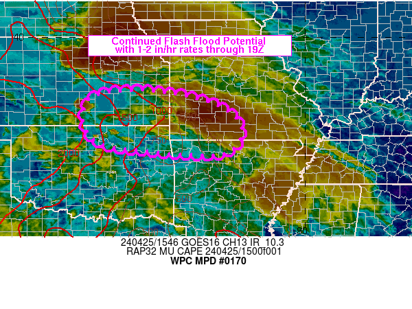
Summary...Periods of training will maintain a localized flash
flood threat for northeastern OK, southeastern KS, northwestern
AR, southwestern MO over the next 3 hours. Rainfall rates of 1-2
in/hr will be possible.

Discussion...1530Z radar imagery over southwestern MO showed a
narrow axis of training heavy rain over southwestern MO.
MRMS-derived (radar only) estimates were 2 to 4 inches through 15Z
with a few Wunderground.com observations showing isolated totals
just over 4 inches in Cherokee and Jasper County through 1530Z.
Peak hourly rainfall within this band was 1-2 inches with as much
as 0.75 inches in 15 minutes. A narrow elevated convergence axis
was helping to focus this band of heavy rain shifting toward the
ESE, seen in KSGF base velocity imagery. The ongoing axis of
training may show signs of weakening as it continues farther east
into more stable environment with SPC mesoanalysis data from 15Z
showing less than 500 J/kg MUCAPE as one moves east from
southwestern MO.

However, back to the west, mostly uncapped elevated instability
over 1000 J/kg was present where larger scale isentropic ascent
and convergence in the 850-700 mb layer is forecast by the RAP to
increase over south-central KS into northeastern OK which may
support the re-development of elevated convection through 19Z.
Current and subsequent convection will have the potential for
training with 1-2 in/hr rainfall rates. but any additional flash
flooding is expected to be localized through 19Z.

Otto

ATTN...WFO...EAX...ICT...LZK...OUN...SGF...TOP...TSA...

ATTN...RFC...ABRFC...LMRFC...MBRFC...NWC...

LAT...LON   38209587 38049430 37669296 36969218 36099268
            36109477 36369686 36959749 37569751 38019714
Download in GIS format: Shapefile
| KML
Last Updated: 1153 AM EDT Thu Apr 25 2024
|


