| WPC Met Watch |
|
|
Mesoscale Precipitation Discussion: #0220 |
|
(Issued at 149 PM EDT Sat May 04 2024
) |
|
| MPD Selection |
|
|
|
|
|

Mesoscale Precipitation Discussion 0220
NWS Weather Prediction Center College Park MD
149 PM EDT Sat May 04 2024

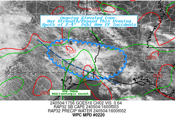
Areas affected...Southeast TX...Southwest LA...

Concerning...Heavy rainfall...Flash flooding possible

Valid 041745Z - 042330Z

SUMMARY...A few scattered elevated T'storms in proximity to highly
saturated soil conditions may further expand over the next few
hours with spots of 1-3" by 00z, possibly resulting in new flash
flooding or compounding ongoing flooded areas.

DISCUSSION...Regional RADAR mosaic and GOES-E imagery suite have
depicted a few bands of elevated weak/scattered convection across
Southeast TX, triggering along the northeast nose of enhanced
800-700mb moisture flux and warm air advection.  Model guidance
suggested backed mid-level flow reducing the forcing, but VWP in
the region hint that is less likely to unfold with 30-40kts of
700mb SW flow at THOU/HGX and more westerly at KLCH.  Lower
level/boundary flow from 850 is more oblique but with CIRA LPW
noting a NW-SE gradient of enhanced SFC-700 flow, while lingering
700-500mb moisture into SW LA; conditions were well for scattered
narrower updraft cells to track fairly parallel for some isolated
1-2" in Polk/Tyler counties.  This is along the northeastern
fringe of areas that have seen greater than 8+" in the last 72hrs
but ground saturation values even into SW LA remain at 75%
suggesting nearly all water is run-off.

Current model and observational trends suggest an increase in
higher theta-E air over the next few hours (20-22z), perhaps
already just off the coastline in a possible early afternoon
sea-breeze enhancement lifting northward.  Higher instability with
SBCAPEs to 3000 J/kg and TPW of 1.5-1.6" combined with
differential heating over the flooded areas north; this may
increase isentropic ascent/convergence and allow for deeper rooted
convection in proximity to the ongoing convection adding the
potential for 1.5-2"/hr rates, resulting in spots of additional
2-3" and spots of 4" totals over the last 3hrs + next 6hrs.  There
is high uncertainty to this evolution but with ongoing expanding
convective activity; new areas of flash flooding is considered
possible through the evening hours.

Gallina

ATTN...WFO...HGX...LCH...SHV...

ATTN...RFC...LMRFC...WGRFC...NWC...

LAT...LON   31249515 31199448 30829270 30089273 29809369
            30089469 30589545 30989553
Download in GIS format: Shapefile
| KML
Last Updated: 149 PM EDT Sat May 04 2024
|


