| WPC Met Watch |
|
|
Mesoscale Precipitation Discussion: #0223 |
|
(Issued at 714 PM EDT Sat May 04 2024
) |
|
| MPD Selection |
|
|
|
|
|

Mesoscale Precipitation Discussion 0223
NWS Weather Prediction Center College Park MD
714 PM EDT Sat May 04 2024

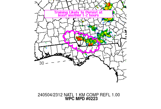
Areas affected...southeastern AL, southwestern GA, northern FL

Concerning...Heavy rainfall...Flash flooding possible

Valid 042313Z - 050200Z

SUMMARY...Training of heavy rain with 2-3 in/hr rainfall rates at
times, may produce areas of flash flooding across portions of far
southwestern GA and possibly into southeastern AL. Uncertainty
exists with how long the threat will persist, but at least another
1-2 hours seems probable.

DISCUSSION...Radar imagery through 23Z has shown a persistent area
of training extending from the southern AL/GA border into the
western GA/FL border. Relatively weak inflow of 10-15 kt was
observed via the KTLH VAD wind plot in the 925-850 mb layer, with
mean steering flow parallel to the outflow, supporting training
from NW to SE. The region also resided on the southern edge of an
upper level diffluent flow with a departing mid-level shortwave to
the north. Peak MRMS rainfall rates have been in the 2-3 in/hr
range and MRMS estimated 2-4 inches has fallen over the past 3
hours (ending 23Z). MLCAPE was 1000-2000 J/kg just south of the
outflow boundary (per SPC mesoanalysis data) which has recently
started to show some southward propagation into northern FL. This
has caused a southward shift to heavy rainfall over Grady and
Thomas counties, but farther upstream toward the AL/GA border,
activity remained stationary.

Conditions appear to be steady state over the next 1-2 hours, but
some further weakening of activity is expected across eastern
locations as the outflow sags southward, however some backbuilding
of heavy rain/training into southeastern AL will be possible.
Flash flood guidance across this region of the Southeast is high
at ~4-6 inches in 3 hours, but the persistence of training with
occasional rainfall rates in the 2-3 in/hr range will allow
eventual runoff and potential for flash flooding. Confidence in
the maintenance of heavy rain across the region beyond 01Z is low,
but the area will continue to be monitored.

Otto

ATTN...WFO...TAE...

ATTN...RFC...SERFC...NWC...

LAT...LON   31618537 30908371 30438370 30468456 30718509
            31318573
Download in GIS format: Shapefile
| KML
Last Updated: 714 PM EDT Sat May 04 2024
|


