| WPC Met Watch |
|
|
Mesoscale Precipitation Discussion: #0226 |
|
(Issued at 245 AM EDT Sun May 05 2024
) |
|
| MPD Selection |
|
|
|
|
|

Mesoscale Precipitation Discussion 0226
NWS Weather Prediction Center College Park MD
245 AM EDT Sun May 05 2024

Areas affected...central, south, and southeast Texas, far
southwestern Louisiana

Concerning...Heavy rainfall...Flash flooding likely

Valid 050643Z - 051243Z

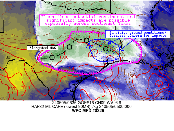
Summary...An extensive MCS is spreading heavy rainfall
southeastward across the discussion area, with 1-2.5 inch/hr rates
noted (some spreading into very sensitive areas near/north of
Houston Metro).  Flash flooding is likely, and significant impacts
are possible.

Discussion...Intense convection across west-central and central
Texas has evolved into an expansive linear segment extending from
near Waco west-southwestward to Del Rio.  Additionally, scattered
convection has deepened in earnest across southeast Texas between
College Station and Lufkin.  Each of the storms are in a
pre-convective environment characterized by moderate instability
(1500 J/kg MLCAPE), abundant moisture (1.5-1.9 inch PW), and weak
inhibition.  Furthermore, enhanced low-level flow associated with
a 40-kt southerly low-level jet was enhancing convergence along
both the leading edge of the MCS in central Texas, while enabling
strong updrafts along a remnant surface boundary in southeast
Texas from convection 1-2 days ago.  The net result of this
pattern is an elongated, generally west-to-east oriented MCS with
efficient rainfall rates (generally over 2 inches/hr in many
areas) along with very slow southward movement, with localized
training/repeating storms and cell mergers supporting very heavy
rainfall.  Unfortunately, some of these storms (especially over
southeast Texas) were producing 2+ inch/hr rain rates over areas
that experienced abundant (4-13 inch) rainfall totals over the
past 72 hours, with sensitive ground conditions continuing to
readily promote flash flooding.

The ongoing scenario will continue to support areas of heavy
rainfall with 2-4 inch/hr rain rates and totals exceeding 6 inches
where training is most pronounced and rain rates can be prolonged.
 Again, sensitive and urbanized areas cannot handle this degree of
rainfall given prior, significant flash flood impacts over the
past several days.  Another widespread flash flood episode is
expected (especially across southeast Texas), and significant
impacts are also likely.

Cook

ATTN...WFO...CRP...EWX...FWD...HGX...LCH...SHV...SJT...

ATTN...RFC...LMRFC...WGRFC...NWC...

LAT...LON   32039637 31879487 31719360 31189242 30529202
            29749232 29559378 28889527 28799704 29269928
            29910023 30489958 31029851 31559773 32009756
Download in GIS format: Shapefile
| KML
Last Updated: 245 AM EDT Sun May 05 2024
|


