| WPC Met Watch |
|
|
Mesoscale Precipitation Discussion: #0227 |
|
(Issued at 825 AM EDT Sun May 05 2024
) |
|
| MPD Selection |
|
|
|
|
|

Mesoscale Precipitation Discussion 0227...Corrected
NWS Weather Prediction Center College Park MD
825 AM EDT Sun May 05 2024

Corrected for Corrected Discussion

Areas affected...Northeast Oklahoma through Central Arkansas

Concerning...Heavy rainfall...Flash flooding likely

Valid 051156Z - 051800Z

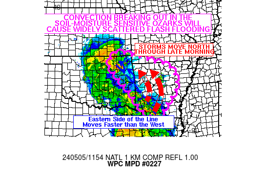
SUMMARY...Flash flooding likely as storms developing out ahead of
an advancing MCS moving across eastern Oklahoma and southern
Arkansas move into the hydrologically sensitive Ozarks.

DISCUSSION...Storms that have developed across Oklahoma and
eastern Arkansas have been producing localized rainfall rates of
up to 2 inches per hour. Instability is between 500 and 1,000 J/kg
of MUCAPE based on SPC Mesoanalysis, and PWATs are around 1.75
inches. The abundant moisture and decent instability will support
additional thunderstorm development through midday across
northeast Oklahoma and much of Arkansas.

The leading edge of the MCS, as well as any pre-MCS convection
will lift northward with time. The MCS is wrapping around a center
point near southeast Oklahoma in response to a northward moving
shortwave in the upper levels. This will keep convection ongoing
and slow-moving to nearly stationary across northeast Oklahoma and
northwest Arkansas. Meanwhile, storms developing on the south and
east side of the line will move faster to the north, which would
decrease flash flooding potential...except those storms will have
a greater tap of moisture and instability, which will allow them
to grow stronger than the convection to their west.

Soils across much of the area are nearly saturated. Heavier
convection will have the potential to produce rates to 2.5 inches
per hour, however even in areas that don't see the heavier
convection, steady rainfall through the morning falling on nearly
saturated soils will result in most of the rainfall converting to
runoff. This will result in widely scattered instances of flash
flooding, with the potential in both hydrologically sensitive
areas of terrain and urban areas for isolated instances of
significant/considerable flash flooding.

Wegman

ATTN...WFO...ICT...LZK...SGF...SHV...TSA...

ATTN...RFC...ABRFC...LMRFC...NWC...

LAT...LON   37169592 37049493 36819374 36549306 36399223
            35939152 34919135 34319178 33839227 33229275
            33229322 33639393 34949495 36109606 36559633
Download in GIS format: Shapefile
| KML
Last Updated: 825 AM EDT Sun May 05 2024
|


