| WPC Met Watch |
|
|
Mesoscale Precipitation Discussion: #0228 |
|
(Issued at 929 AM EDT Sun May 05 2024
) |
|
| MPD Selection |
|
|
|
|
|

Mesoscale Precipitation Discussion 0228
NWS Weather Prediction Center College Park MD
929 AM EDT Sun May 05 2024

Areas affected...Portions of Southeast Texas

Concerning...Heavy rainfall...Flash flooding likely

Valid 051328Z - 051800Z

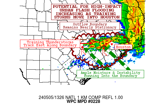
SUMMARY...Flash flooding likely as storms developing along a
boundary west of Houston track along the boundary over
hydrologically sensitive areas west of Houston and into the
Houston Metro. Considerable urban flash flooding potential is
increasing.

DISCUSSION...Training convection developing west of Houston is
moving east towards Houston this morning. The storms have formed
along an outflow boundary that was set by the MCS that is
departing off to the east. CAMs guidance suggests the boundary
will remain nearly stationary through the day. Abundant Gulf
moisture moving in from the Gulf will continue to feed moisture
and instability into the storms through midday. Thus, the
potential for significant, considerable, and high-impact urban
flash flooding is increasing.

CAMs guidance remains in poor agreement on how this boundary will
behave through the day today. Much of the guidance is much further
south with the boundary than where it has actually developed.
However, they are in better agreement that the boundary convection
will not only continue to develop, but gradually backbuild west to
as far as the Rio Grande. Should that occur a follow-up MPD may be
needed. For now, the area of concern remains for portions of
Southeast Texas, as regardless of how far west the convection
develops later, storms are likely to continue in the highlighted
area.

Wegman

ATTN...WFO...EWX...HGX...

ATTN...RFC...WGRFC...NWC...

LAT...LON   30299528 30279493 29879455 29419472 29279486
            29179521 28919548 28869636 29179688 29339743
            29749751 30129726 30159733 30259708 30249631
            30259575
Download in GIS format: Shapefile
| KML
Last Updated: 929 AM EDT Sun May 05 2024
|


