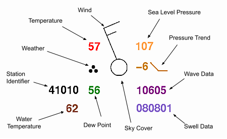
The image below represents a sample ship or buoy observation. For more information about any parameters plotted in the station model, please click on that parameter or the links provided below.
[Temperature] [Weather] [Dew point] [Wind] [Sea-level pressure]
[Pressure trend] [Sky cover] [Water temperature]
[Swell information] [Wave information] [Station Identifier]
The current air temperature measured to the nearest whole degree Farenheit.
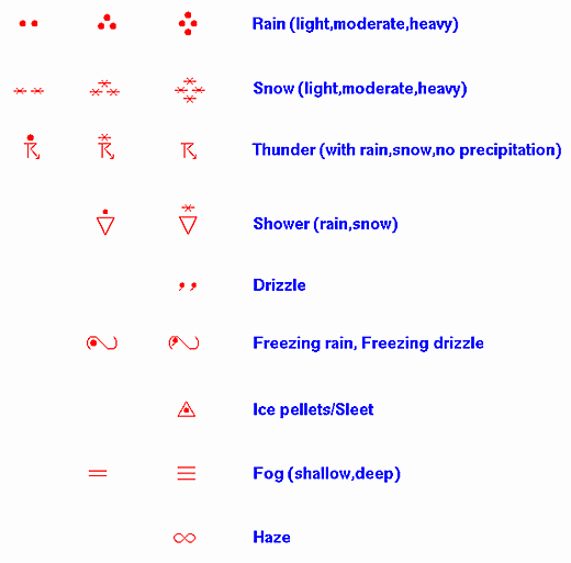
A weather symbol is plotted if at the time of observation, there is either precipitation occurring or a condition causing reduced visibility.
Below is a list of the most common weather symbols:
The current dew point temperature measured to the nearest whole degree Farenheit.
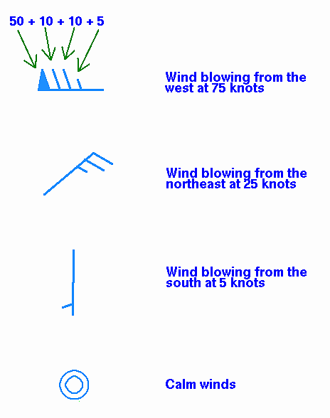
Wind is plotted in increments of 5 knots (kts), with the outer end of the symbol pointing toward the direction from which the wind is blowing. The wind speed is determined by adding up the total of flags, lines, and half-lines, each of which have the following individual values:
Flag: 50 kts
Line: 10 kts
Half-Line: 5 kts
If there is only a circle depicted over the station with no wind symbol present, the wind is calm. Below are some sample wind symbols:
Sea-level pressure is plotted in tenths of millibars (mb), with the leading 10 or 9 omitted. For reference, 1013 mb is equivalent to 29.92 inches of mercury. Below are some sample conversions between plotted and complete sea-level pressure values:
410: 1041.0 mb
103: 1010.3 mb
987: 998.7 mb
872: 987.2 mb
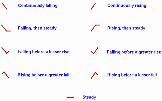
The pressure trend has two components, a number and symbol, to indicate how the sea-level pressure has changed during the past three hours. The number provides the 3-hour change in tenths of millibars, while the symbol provides a graphic illustration of how this change occurred. Below are the meanings of the pressure trend symbols:
The current water temperature measured to the nearest whole degree Farenheit.
The swell direction, period, and height are represented in the surface observations by a 6-digit code. The first two digits represent the swell direction, the middle digits describe the swell period (in seconds), and the last two digits are the swell's height (in half meters). Below are two examples:090703
09 -- The swell direction is from 90 degrees (i.e. it is coming from due east).
07 -- The period of the swell is 7 seconds.
03 -- The height of the swell is 3 half meters.271006
27 -- The swell direction is from 270 degrees (due west).
10 -- The period is 10 seconds.
06 -- The height of the swell is 6 half meters.
The period and height of waves are represented by a 5-digit code. The first digit will be a "1" for buoy observations and a "2" for ship observations. The second and third digits describe the wave period (in seconds), and the final two digits give the wave height (in half meters). Below are two examples:10603
1 -- A group identifier for a buoy.
06 -- The wave period is 6 seconds.
03 -- The wave height is 3 half meters.20515
2 -- A group identifier for a ship observation.
05 -- The wave period is 5 seconds.
15 -- Wave height is 15 half meters.
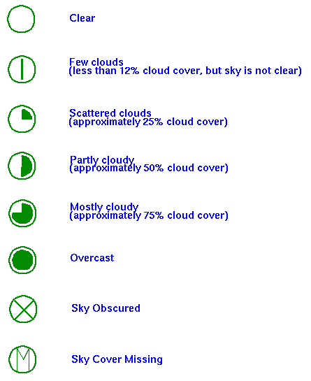
The amount that the circle at the center of the station plot is filled in reflects the approximate amount that the sky is covered with clouds. Below are the common cloud cover depictions:
A weather symbol is plotted if at the time of observation, there is either precipitation occurring or a condition causing reduced visibility.
Below is a list of the most common weather symbols:
The format of the station identifier depends on the observing platform.
- Ship -- Typically 4 or 5 characters. If 5 characters, then the fifth will usually be a digit.
- Buoy -- Whether drifting or stationary, a buoy will have a 5-digit identifier. The first digit will always be a "4".
- C-MAN -- Stands for Coastal-Marine Automated Network, and are usually close to coastal areas. Their identifier will appear like a 5-character ship identifier, however the 4th character will identify off which state the platform is located. For example, "SRST2" is a C-MAN station located along the Texas coast (in this case near Sabine, TX).
- Land -- Land stations will always be 3 characters, making them easily distinguishable from ship, buoy, and C-MAN observations.