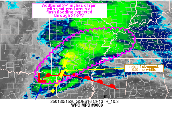
Mesoscale Precipitation Discussion 0008
NWS Weather Prediction Center College Park MD
618 PM EST Tue Jan 09 2024

Areas affected...Eastern PA...New Jersey...Southern NY...Western
CT...

Concerning...Heavy rainfall...Flash flooding likely

Valid 092317Z - 100417Z

SUMMARY...Rainfall rates will pick up this evening as the elevated
airmass becomes marginally unstable. This along with the areas of
snowmelt and/or low flash flood guidance will lead to isolated or
widely-scattered instances of flash flooding through this evening.

DISCUSSION...The latest GOES-East longwave IR imagery indicates a
well-established Warm Conveyor Belt (WCB) across the Eastern
Seaboard, with enhanced (higher) cloud tops beginning to expand
across the northern Mid Atlantic Region. Meanwhile, the 2100 UTC
surface analysis indicated two areas of low pressure, with the
primary low of 979 mb across northern Indiana, and a secondary 991
mb low across north-central North Carolina. Upper-level forcing
ahead of both lows will increase this evening over the outlook
area, owing to strong upper-level divergence enhanced by the
left-exit region of an upper level jet streak. Robust, highly
anomalous low-to-mid layer moisture transport will ensue, as both
the 850 mb southerly flow and 850-700 mb moisture flux anomalies
increase to over 5 standard deviations above normal per the GEFS
and SREF. This as PWs climb between 1 to 1.25 inches, which is 3
to 3.5 standard deviations above normal for early January.

The strong WAA/positive theta-e advection will also lead to
weakening static stability aloft, with the latest HRRR indicating
MUCAPEs on the order of 150-300 J/Kg toward midnight. As such,
hourly rain rates of 0.50 to 0.75" will become more common after
00Z per the latest CAM suite, with most areas receiving 3-hourly
rainfall rates of 1-2 inches. This along with the snowmelt in some
(farther inland) areas, and/or across areas with otherwise low
flash flood guidance (1.5" or less within 3 hours), will  result
in some isolated to widely scattered instances of flash flooding
going through the evening. The more urbanized locations will also
be susceptible to seeing more notable runoff concerns.

Hurley

ATTN...WFO...ALY...BGM...CTP...LWX...OKX...PHI...

ATTN...RFC...MARFC...NERFC...NWC...

LAT...LON   42047383 41977322 41637301 41307354 40697420
            40297409 39737497 39497619 39947649 40557647
            41167610 41777511
Download in GIS format: Shapefile
| KML
Last Updated: 618 PM EST Tue Jan 09 2024
