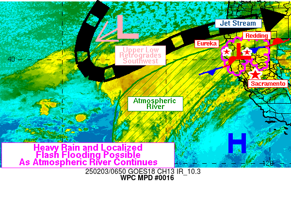
Mesoscale Precipitation Discussion 0016
NWS Weather Prediction Center College Park MD
1204 PM EST Sat Jan 20 2024

Areas affected...northern CA into southwestern OR

Concerning...Heavy rainfall...Flash flooding possible

Valid 201703Z - 210500Z

Summary...Heavy rainfall will gradually shift northward from
northern California into southwestern Oregon today. Peak rainfall
rates over 0.5 in/hr and 12 hour totals of 2-4 inches are expected
which may lead to localized areas of flooding.

Discussion...1630Z water vapor imagery (6.9 micron channel) from
GOES West showed a closed low centered near 42.5N 125.1W, moving
off toward the NNE. Areas of heavy rain have been observed to the
southeast of the mid to upper level low across northern CA since
~11Z with the heaviest rainfall focusing across Humboldt County.
Recent RAWS and Wunderground observations have shown hourly
rainfall in the 0.50 to 0.75 inch range within the King Range and
6 hour totals in the 2-3 inch range. This area of northern CA was
located beneath the left exit region of a subtle jet streak aloft
(currently crossing the coast), measuring at least 60-70 kt per
GOES West DMVs near 300 mb and beneath a region of maximized
diffluence aloft. 850 mb winds per the KBHX VAD wind plot had been
50-60 kt from the SSE but have since veered to SSW and weakened
into the 40-50 kt range as the corridor of stronger 850 mb winds
has shifted to the far northern CA/southern OR coast with the
closed low movement. Precipitable water values were measured by
recent GPS and blended TPW data to be 0.8 inches along the coast
to just over 1 inch offshore the OR/CA coasts.

Short term RAP guidance shows the mid to upper level low
continuing toward the NNE while weakening through 00Z. This
movement will allow low level winds to continue to veer toward the
SSW and SW through the day, promoting more of an onshore component
to the winds into Del Norte and Curry counties. 850 mb winds are
expected to maximize in the 40-50 kt range for these northern
locations and peak IVT values will remain steady in the 400-500
kg/m/s range after initial weakening this morning in the vicinity
of Cape Mendocino. Southwest facing slopes of the Coastal Ranges
are expected to see several hours with steady hourly rainfall in
the 0.25 to 0.50 inch range over the next 6-9 hours, with hourly
totals occasionally peaking above 0.5 in/hr. Additional rainfall
through 04Z/05Z is expected to peak in the 2-4 inch range for Del
Norte and Curry counties into the upslope favored terrain of the
Klamath and southern Cascade Mountains below 5000-6000 feet (with
snow above those levels). Considering 150-300 percent of average
rainfall over the past week for the region, soil moisture and area
streams/rivers are running above normal. Additional heavy rainfall
may support areas of renewed flooding from northern CA into
southwestern OR.

Otto

ATTN...WFO...EKA...MFR...STO...

ATTN...RFC...CNRFC...NWRFC...NWC...

LAT...LON   43082448 43032431 42952407 42822382 42442370
            42292356 42192348 42082338 42012336 41952336
            41822339 41712340 41582333 41402328 41342325
            41212318 41132318 41062318 40942313 40952291
            41172255 41182246 41362207 41132197 40862226
            40622247 40432269 40232278 40052278 39882287
            39672293 39512301 39422323 39372358 39362393
            39442418 39592430 40012471 40462478 41472448
            42352476 42712481 42932472
Download in GIS format: Shapefile
| KML
Last Updated: 1204 PM EST Sat Jan 20 2024
