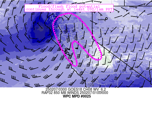
Mesoscale Precipitation Discussion 0025
NWS Weather Prediction Center College Park MD
432 AM EST Wed Jan 24 2024

Areas affected...central/south Texas eastward through Louisiana
and far southwestern Mississippi

Concerning...Heavy rainfall...Flash flooding likely

Valid 240931Z - 241531Z

Summary...Flash flood potential continues across the discussion
area through 1530Z and beyond.  Locally significant impacts are
ongoing and should continue - especially across central Texas
where 2-7 inches of rain has fallen over the last 24 hours.

Discussion...The flash flood threat continues across the
discussion area, but is focused within a couple of regimes.  The
first exists across central to southeastern Texas.  Despite storms
being undercut by outflow that currently extends from Houston to
just south of San Antonio, 7C/km mid-level lapse rates and
abundant forcing for ascent from mid-level troughing over the
southern Rockies continues to support robust updrafts near/just
east of San Antonio.  These cores were moving east-northeastward
and approaching areas that have already received 2-7 inch rainfall
totals over the past 24 hours.  FFG thresholds are very low (near
zero), and multiple reports of flooding have already been
received.   With continued ascent associated with the upstream
trough continuing to persist over the area through the day,
precipitation is likely to continue at times today and remain at
least briefly heavy (0.5-1.0 inch/hr at times).  In this regime,
widespread and locally significant flash flooding can be expected
along an axis from Gonzales to San Jacinto counties.

The second regime exists across portions of far southeast Texas
and Louisiana.  Here, widespread, deep convection has evolved
within a strong warm-advection regime ahead of the synoptic cold
front (still located over Texas) and an outflow boundary extending
from near Houston to near Alexandria, LA.  1.8 inch PW values and
increasing surface-based CAPE throughout the morning will continue
to result in efficient rainfall processes, while localized
training/repeating of cells along and ahead of the boundaries will
continue to support areas of 1-2 inch/hr rain rates that could
persist potentially for 2-4 hours.  These rain rates are also
likely to cause flash flooding - especially where prolonged rain
rates can persist over sensitive ground conditions.  FFGs across
central and southern Louisiana are notably higher compared to
central/eastern Texas, and longer durations of heavy rain will
likely be required to wet grounds enough for a broader-scale flash
flood threat to materialize.  Recent CAMs/models do support the
notion of prolonged heavy rain potential across areas from Houston
to Lake Charles, Alexandria, and the Mississippi River near
Natchez through 1530Z.

Cook

ATTN...WFO...CRP...EWX...FWD...HGX...JAN...LCH...LIX...SHV...

ATTN...RFC...LMRFC...WGRFC...NWC...

LAT...LON   32649177 32489107 31429078 30659087 30079243
            29289391 28159652 28719920 29489944 29829897
            30549789 31369632 32169391
Download in GIS format: Shapefile
| KML
Last Updated: 432 AM EST Wed Jan 24 2024
