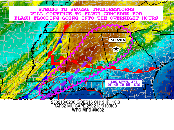
Mesoscale Precipitation Discussion 0032
NWS Weather Prediction Center College Park MD
517 AM EST Thu Jan 25 2024

Areas affected...far southeastern TX into central LA, MS and
northern AL

Concerning...Heavy rainfall...Flash flooding likely

Valid 251015Z - 251615Z

SUMMARY...Heavy rain will move across portions of the Lower
Mississippi Valley with peak rainfall rates of 1-2 in/hr through
16Z. Areas of flash flooding are expected given many locations
across LA, MS and AL have saturated soils due to heavy rain over
the past 24 hours.

DISCUSSION...10Z regional radar imagery showed a continuous line
of thunderstorms extending from southeastern TX into the western
Gulf of Mexico, located just ahead of an advancing cold front in
the region. The front and thunderstorms were located ahead of a
well defined mid to upper level shortwave tracking to the ENE
across west-central TX as seen on water vapor imagery. DPVA ahead
of the shortwave and divergence aloft within the right entrance
region of a 110 kt jet streak just east of the shortwave trough
were providing strong ascent across the region which was
characterized by 500-1500 J/kg MUCAPE per the 09Z SPC
mesoanalysis. In the lower levels of the atmosphere, vAD winds
from KHGX and KLCH sampled 25-30 kt at 850 mb from the south,
supporting robust moisture transport from the Gulf of Mexico into
the Gulf Coast states with recent GPS measured PWAT values ranging
from 1.5 to 1.8 inches from southern LA to the central MS/AL
border.

As the mid to upper level shortwave and continues toward the
northeast this morning, the associated cold front will steadily
move east across LA, reaching western MS near 16Z. A solid line of
thunderstorms is expected to follow the cold front's movement
toward the east, preceded by warm advection induced pre-frontal
convection at times. While the line should remain fairly
progressive toward the east, brief training of heavy rain will
allow for rainfall rates of 1-2 in/hr at times and additional
totals of up to 3 inches through 16Z. These rains will be falling
on top of 3 to 6+ inches of rain which fell from far southeastern
TX into southern/central LA into south-central MS over the past 24
hours, leading to saturated soils in many locations. The addition
of another 1-3 inches of rain, which may fall over a 1-2 hour
window, is likely to lead to some renewed areas of flash flooding
across LA into MS and perhaps northwestern AL through 16Z.

Otto

ATTN...WFO...BMX...HUN...JAN...LCH...LIX...MEG...MOB...SHV...

ATTN...RFC...LMRFC...SERFC...WGRFC...NWC...

LAT...LON   35108611 34348606 33128736 31858898 30539050
            29619217 29499382 30149428 31569330 33219114
            34668810
Download in GIS format: Shapefile
| KML
Last Updated: 517 AM EST Thu Jan 25 2024
