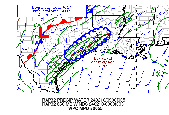
Mesoscale Precipitation Discussion 0055
NWS Weather Prediction Center College Park MD
542 AM EST Sat Feb 10 2024

Areas affected...portions of southeast TX & western LA

Concerning...Heavy rainfall...Flash flooding possible

Valid 101041Z - 101641Z

Summary...A low-level convergence zone is expected to gather an
increasing amount of thunderstorm activity through the morning
hours.  Hourly rain totals to 2" with local amounts to 4" are
possible.

Discussion...A shortwave moving near El Paso has been enhancing
outflow aloft across much of central and eastern TX and slowly
eroding CIN.  Precipitable water values near the TX coast have
risen into the 1.5-1.75" range per GPS data.  MU/ML CAPE has been
more or less stable near 250 J/kg on SPC mesoanalyses.  A
low-level convergence zone, occasionally showing up in the surface
pattern but more evident at 925 hPa and 850 hPa, has been moving
little near the Middle and Upper TX coasts and across western LA
within the warm sector of a low over TX, which helped focus a band
of showers hours ahead of what was suggested by the 00z HREF.
Around 3 a.m. CST, there was a spike in hourly rain totals up to
1.5", also earlier/more than anticipated by the guidance, from the
Galveston/Harris County border into southeast Liberty County.

Various model fields suggest that instability will be stable or
slowly increase initially, before going upward faster later this
morning near the southern end of the low-level convergence zone
either due to daytime heating or the approaching shortwave.  A
boundary itself may shift slightly northward.  The past few HREF
runs have been slowly trending to a wetter signal across this
region, focusing more on this convergence zone and less on the
front to the north.  As the shortwave near westernmost TX
approaches, the expectation is for convective coverage to increase
near the convergence zone, particularly after 13z per the 00z/06z
HREF guidance is to be believed.  The 00z ARW appears best placed
with what's expected, based on what's occurred thus far, though
its amounts could be a little light.  Hourly rain totals are
expected to peak in the 2" range, with local amounts to 4" being
possible, which would exceed the three hour flash flood guidance.
Any heavy rain-related issues would be isolated to widely
scattered, with urban areas most sensitive.

Roth/Asherman

ATTN...WFO...HGX...LCH...SHV...

ATTN...RFC...LMRFC...WGRFC...NWC...

LAT...LON   31799320 31209252 30029415 28999604 29509646
            30789509
Download in GIS format: Shapefile
| KML
Last Updated: 542 AM EST Sat Feb 10 2024
