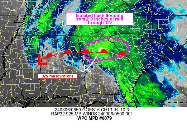
Mesoscale Precipitation Discussion 0079
NWS Weather Prediction Center College Park MD
206 AM EST Wed Mar 06 2024

Areas affected...north-central GA into western SC

Concerning...Heavy rainfall...Flash flooding possible

Valid 060703Z - 061215Z

SUMMARY...Isolated flash flooding will be possible across
north-central GA into western SC through 12Z from slow moving
areas of moderate to heavy rain. Hourly rainfall of 0.5 to 1.0
inches and totals of 2-3 inches may support excess runoff within
low lying and poor drainage locations.

DISCUSSION...Regional radar imagery across GA at 0630Z showed a
region of stratiform rain over northeastern GA, with peak observed
hourly rainfall totals of 0.5 to 1.0 inches from downtown Atlanta
to locations just east of the city. KFFC rainfall estimates
appeared too low but MRMS was closer to selected gauge reports
from the Wunderground.com network.

Rainfall was occurring ahead of a negatively tilted upper trough
over AL and southern GA, with diffluent flow downstream and
southeasterly low level winds (centered near 925 mb) near 30 kt
over southern GA into northern FL, converging near a strengthening
925 mb warm front over north-central GA. Convergence was being
enhanced ahead of a remnant low level circulation advancing
northeastward from the south-central AL/GA border as seen on
longer loops of IR imagery.

While PWATs were anomalous for early March (1.25 to 1.50 inches),
MUCAPE was lacking according to the 06Z SPC mesoanalysis with only
about 100 J/kg located along the south side of the moderate to
heavy precipitation shield. However, continued low level moisture
advection from the south coupled with cooling 500 mb temperatures
as the mid-level reflection of the upper trough nears should act
to increase MUCAPE values into the 250 to 500+ J/kg range through
12Z along with heavy rainfall coverage for north-central GA.

The axis of low level forcing is expected to slowly shift east
through 12Z, resulting in a prolonged period of moderate to heavy
rain with hourly totals approaching 1 inch at times. The axis of
heavy rain will translate eastward through 12Z, resulting in
localized 2-3 inch totals from north-central GA into portions of
western SC. These rainfall totals may result in areas of isolated
flash flooding, mainly across locations that are low lying and/or
of poor drainage.

Otto

ATTN...WFO...CAE...FFC...GSP...

ATTN...RFC...SERFC...NWC...

LAT...LON   34728313 34488223 33988181 33538271 33288447
            33688500 34248479
Download in GIS format: Shapefile
| KML
Last Updated: 206 AM EST Wed Mar 06 2024
