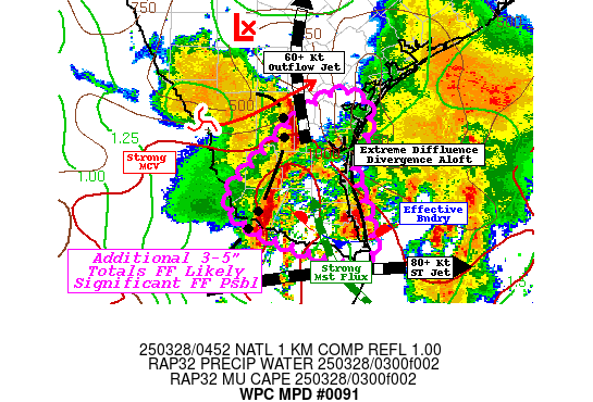
Mesoscale Precipitation Discussion 0091
NWS Weather Prediction Center College Park MD
730 PM EST Fri Mar 08 2024

Areas affected...portions of the northeast Gulf Coast

Concerning...Heavy rainfall...Flash flooding possible

Valid 090029Z - 090629Z

Summary...Heavy rain with embedded thunderstorms continues to
spread eastward along and inland of the northeast Gulf Coast.
Hourly rain totals to 2.5" with local amounts to 5" could lead to
widely scattered flash flooding.

Discussion...Warm air advection east of a wave of low pressure
entering southernmost MS has lead to a broad area of heavy
rainfall, with showers and thunderstorms along its southern
periphery.  This is occurring north of the polar warm front (the
southern edge of the dew point gradient) and not far from a
strengthening outflow boundary/coastal front-like feature forming
inland across the Southeast, which has greater temperature
gradient.  This is occurring south of an upper level low entering
northwest IL and ahead of a southern stream shortwave moving east
into the northwest Gulf Coast, so the atmosphere is quite
diffluent/divergent aloft.  GPS data indicate precipitable water
values as high as 2.1" across southeast LA.  ML CAPE of 500-1000
J/kg continues to edge eastward through southernmost MS and AL
into the FL Panhandle.  Convergent 850 hPa inflow of 30-55 kts is
seen in area VAD wind profiles.

A combination of increasing low-level frontogenesis, sufficient
instability, and sufficient effective bulk shear is expected to
lead to heavy rain-related issues for several more hours in this
area through a combination of cell training and embedded
mesocyclones.  The mesoscale guidance continues to err northwest,
proving to be too slow and too poleward, as is their bias.  Hourly
rain totals to 2.5" with local amounts to 5" are possible past
midnight CST/1 a.m. EST.  Much of this area has been relatively
dry over the past week -- any flash flooding issues would be more
likely in urban areas, so think the issues should be widely
scattered at best.  This led to the use of the flash flooding
possible category.

Roth

ATTN...WFO...BMX...FFC...JAN...LIX...MOB...TAE...

ATTN...RFC...LMRFC...SERFC...NWC...

LAT...LON   32968394 31848361 30678496 30298619 30058946
            30468994 31238922 32958533
Download in GIS format: Shapefile
| KML
Last Updated: 730 PM EST Fri Mar 08 2024
