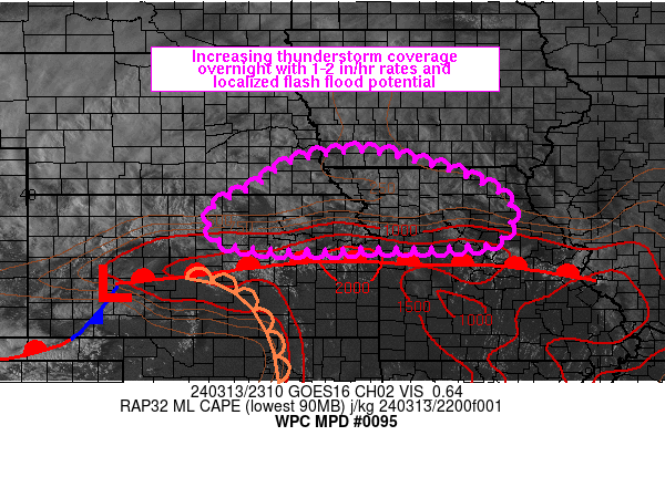
Mesoscale Precipitation Discussion 0095
NWS Weather Prediction Center College Park MD
727 PM EDT Wed Mar 13 2024

Areas affected...northeastern KS into northern MO and adjacent MO
Valley

Concerning...Heavy rainfall...Flash flooding possible

Valid 132325Z - 140525Z

Summary...Thunderstorm coverage and flash flood potential are
expected to increase overnight across portions of the middle MO
River Valley. Repeating and training of cells with rainfall rates
of 1-2 in/hr will be possible. There is some uncertainty with
timing, but the flash flood threat is expected to be greatest
after 03Z.

Discussion...23Z surface observations and fading visible satellite
imagery placed a surface low near DDC with a warm front extending
eastward into MO, roughly 50 miles south of I-70. A bulged dryline
was analyzed across south-central KS into central OK with early
stages of convective initiation over eastern KS. 23Z SPC
mesoanalysis data showed MLCAPE of 1000 to 2000+ J/kg south of the
warm front in KS and MO, with weak to near-zero CIN, along with
PWATs ranging from 0.7 to 1.1 inches. Meanwhile, water vapor
imagery showed a mid-level shortwave over western KS, tracking
toward the northeast with an upper level jet max over the southern
High Plains, with RAP analysis estimates of 100-110 kt, on the
south side of a western trough axis.

Over the next 6 hours, as the shortwave over western KS and the
larger scale trough over the West continues to advance downstream,
upper level divergence and diffluence should increase across the
MO Valley within the left exit region of the upper level jet max.
In the lower levels, 850 mb wind speeds are forecast by the RAP to
increase into the 40-50 kt range by 03-06Z over eastern KS,
overrunning the warm front, leading to elevated convection along
the NE/KS border, eastward into northern MO and northward toward
the IA/MO border. Increased forcing in the lower and upper levels
should lead to an expansion of organized thunderstorms through 03Z
and while PWATs are modest within the pre-convective environment,
sufficient shear is in place for organized, rotating storms which
should help to boost precipitation efficiency. Bunkers-right
supercell motions and upshear Corfidi vectors are generally west
to east, or parallel to the slow moving warm front. Possible
congealing of storms would have both a northeastward and eastward
component to them, while additional upstream development may
support repeating and training from the instability pool south of
the warm front. 1-2 in/hr rates and 2+ inch totals in 2 to 3 hours
time through 05Z may support localized flash flooding across the
region, despite very dry antecedent conditions with area FFG
values showing 1.5 to 2.5 inches in 3 hours.

Otto

ATTN...WFO...DMX...EAX...GID...ICT...LSX...OAX...TOP...

ATTN...RFC...ABRFC...MBRFC...NCRFC...NWC...

LAT...LON   40889462 40049206 39119202 38939306 38919484
            38869648 39029791 39689813 40159728 40699636
Download in GIS format: Shapefile
| KML
Last Updated: 727 PM EDT Wed Mar 13 2024
