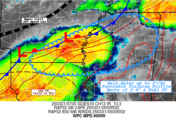
Mesoscale Precipitation Discussion 0099
NWS Weather Prediction Center College Park MD
609 PM EDT Thu Mar 14 2024

Areas affected...east-central Missouri, central/southern Illinois,
central/southern Indiana, northern Kentucky, western/central Ohio

Concerning...Heavy rainfall...Flash flooding possible

Valid 142151Z - 150351Z

Summary...Relatively fast-moving storms are favorably oriented for
training/repeating and a quick 1-1.5 inches of rainfall in
localized spots.  This could result in an isolated flash flooding
across the discussion area through 03Z this evening.

Discussion...Scattered convection continues to deepen and
intensify across east-central Missouri and western Illinois.  The
storms are exhibiting primarily a cellular mode, but are oriented
along WSW-ENE axes (from Springfield, IL westward to south of
Columbia, MO and also south through southwest of Saint Louis)
generally parallel to fast flow aloft.  A limited amount of
training has been observed, which has enhanced rain rates to close
to 1 inch/hr in spots (per MRMS) despite relatively fast storm
motions (30-40 knots).  Another east-west oriented band was
located across central Indiana (Kokomo to south of Fort Wayne)
that was oriented favorably for training.  Additionally, a cluster
of more mature cells/lines were located across south-central and
southwestern Missouri that will move eastward through the
discussion area over the next several hours.

The downstream airmass has heated and destabilized sufficiently to
support deep convection through at least 03Z this evening.  That
airmass is characterized by areas of 1000-3000 J/kg SBCAPE
(highest in Missouri) and 1-1.3 inch PW values.  The airmass will
continue to support deep convection along with localized training,
cell mergers, and occasional spots of 1-1.5 inch rainfall rates.
These rates will approach FFG thresholds (generally in the 1-2
inch/hr range - lowest across portions of Ohio, Kentucky, and
eastern Indiana). NASA Sport soil moisture values indicate
widespread, dry antecedent conditions that will need to be
overcome by training convection (espcially in Illinois).  The
aforementioned scenario suggests that an isolated/spotty flash
flood risk should materialize through 03Z especially where
convective training is most pronounced.

Cook

ATTN...WFO...CLE...ILN...ILX...IND...IWX...JKL...LMK...LOT...
LSX...PAH...

ATTN...RFC...LMRFC...MBRFC...NCRFC...OHRFC...NWC...

LAT...LON   41108389 39608290 38408346 37428675 37088888
            37308997 38589111 39699114 40628891 40998669
Download in GIS format: Shapefile
| KML
Last Updated: 609 PM EDT Thu Mar 14 2024
