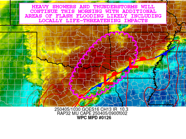
Mesoscale Precipitation Discussion 0126
NWS Weather Prediction Center College Park MD
808 PM EDT Mon Apr 01 2024

Areas affected...south-central IL/IN into far southwestern OH

Concerning...Heavy rainfall...Flash flooding likely

Valid 020007Z - 020600Z

Summary...Training of heavy rain from west to east is expected to
produce at least localized flash flooding from a quick 2-4 inches
of rain. The greatest threat will exist across south-central IL/IN
through 06Z.

Discussion...Regional radar imagery at 2330Z showed two supercells
in eastern MO, just south of I-70 along with a linear segment
oriented west to east, crossing I-55 about 20 miles south of
Springfield, IL. These thunderstorms were located along or just
north of a rain-cooled outflow boundary that extended WSW to ENE
through Saint Louis. The rain-cooled outflow was acting as the
effective warm front within an axis of 500 to 1000+ J/kg MLCAPE
via the 23Z SPC mesoanalysis.

As a mid to upper-level trough axis continues to advance eastward
across the central/southern Plains, low level inflow across the
outflow boundary will increase over the next few hours. 25-40 kt
of southerly flow in the 925-850 mb layer will increase
overrunning while upper level divergence increases within the
right-entrance and left-exit regions of dual jets at 250 mb
downstream of the main upper trough axis to the west. Increasing
thunderstorm coverage is expected to expand from west to east with
time. Steering flow quasi-parallel to the low level axis of
forcing should support some areas of training, especially as
upstream convection over west-central MO approaches. 1-2 in/hr
rainfall rates and 2-4 inches in 2-3 hours is expected to produce
at least a few areas of localized flash flooding with the threat
expanding east with time through 06Z.

Localized thunderstorm development will be possible south of the
warm front into southern portions of IL/IN over the next few
hours, but coverage and the potential for flash flooding does not
appear as great compared to locations farther north.

Otto

ATTN...WFO...ILN...ILX...IND...LMK...LSX...PAH...

ATTN...RFC...NCRFC...OHRFC...NWC...

LAT...LON   40368794 39998512 39318455 38868483 38418648
            38348868 38948996 39968960
Download in GIS format: Shapefile
| KML
Last Updated: 808 PM EDT Mon Apr 01 2024
