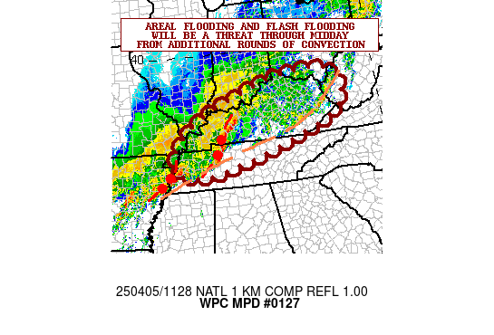
Mesoscale Precipitation Discussion 0127
NWS Weather Prediction Center College Park MD
1033 PM EDT Mon Apr 01 2024

Areas affected...northeastern OK/southeastern KS into MO and far
northwestern AR

Concerning...Heavy rainfall...Flash flooding possible

Valid 020231Z - 020630Z

Summary...A threat of flash flooding will continue from portions
of northeastern OK/southeastern KS into southwestern/central MO
and far northwestern AR through 07Z. Multiple rounds of heavy rain
with areas of training are expected to result in some 2 to 3+ inch
totals through 07Z.

Discussion...Regional radar imagery at 02Z showed a cluster of
thunderstorms over eastern MO into central IL and a second cluster
over central OK into southeastern KS. Additional storms were noted
ahead of a cold front, approaching central OK. Embedded MCVs were
noted within some of the convective clusters, advancing toward the
northeast. An elongated outflow boundary was observed on 02Z
surface observations just south of the convection and just south a
line connecting STL to JLN to TUL to OKX. SPC mesoanalysis data
from 02Z indicated ML and MU CAPE remained in the 500 to 1500 J/kg
range from northeastern OK into central MO, along with PWATs of
1.1 to 1.5 inches.

DPVA ahead of an approaching mid-level shortwave over KS/OK/west
TX, low level flow of 30-50 kt (850 mb) ahead of an eastward
advancing cold front approaching from central OK along with
divergent and diffluent flow aloft will be enough to maintain
forcing for continued convection over at least the next few hours
from OK into the mid-MS Valley. Multiple rounds of convection
near/north of the outflow boundary will have the greatest
potential for 1-2 in/hr rainfall rates and training from SW to NE
or WSW to ENE given similarly oriented steering flow aloft. An
additional 2 to 3 inches (locally higher) is expected to maintain
a threat of flash flooding from the lower Plains into the Midwest.

Otto

ATTN...WFO...EAX...ICT...LSX...LZK...OUN...PAH...SGF...TSA...

ATTN...RFC...ABRFC...LMRFC...MBRFC...NCRFC...NWC...

LAT...LON   39159028 38298921 37429034 36319285 35429577
            35759702 36259701 37159574 37709451 38419310
            38819218
Download in GIS format: Shapefile
| KML
Last Updated: 1033 PM EDT Mon Apr 01 2024
