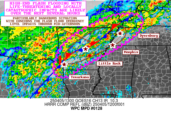
Mesoscale Precipitation Discussion 0128
NWS Weather Prediction Center College Park MD
207 AM EDT Tue Apr 02 2024

Areas affected...southern through eastern Missouri,
southern/central Illinois, southern/central Indiana, portions of
Kentucky, and southwestern Ohio

Concerning...Heavy rainfall...Flash flooding possible

Valid 020606Z - 021200Z

Summary...A series of convective complexes were merging/growing
upscale while producing 1+ inch/hr rain rates in spots.  These
trends will continue through the next 3-6 hours, posing flash
flood potential across the discussion area.

Discussion...A series of forward propagating, linear convective
segments have began to grow upscale over the past 1-2 hours,
forming a large convective complex that extends from southwestern
Missouri (near Springfield) to near Saint Louis to near Terre
Haute, IN.  The complex was forming a relatively extensive outflow
that merges with a synoptic warm front across Illinois and
Indiana.  Meanwhile, the pre-convective environment supporting the
ongoing activity was characterized by approximately 1000 J/kg
SBCAPE and strong southwesterly inflow along a 45-60 knot
low-level jet axis emanating from the Ozarks.  Convergence along
the nose of this jet and strong low-level warm advection will
likely maintain deep convection through at least 12Z this morning.
 The orientation of convection, however, with outflow generally
parallel to west-southwesterly steering flow aloft will allow for
areas of localized training and rain rates exceeding 1 inch/hr.
These rates were generally less than FFG thresholds (around 1.5
inch/hr), and a slow but notable rightward component of motion
relative to flow aloft was allowing for heavier rainfall to move
toward drier soils nearer the Ohio River.

The ongoing scenario should support at least a modest flash flood
risk over the next few hours.  Areas of convective training should
continue through 12Z that could support rain rates exceeding 1.5
inches/hr at times, with low-lying and/or sensitive areas
potentially experiencing excessive runoff.  A lengthy duration of
heavier rainfall could also result in 2 inch amounts over a three
hour period that would also contribute to flash flood concerns
(with 2 inch/3 hr FFG thresholds noted across the area).  The
leading edge of the expanding MCS should reach southwestern Ohio
areas by 09Z.

Cook

ATTN...WFO...ILN...ILX...IND...LMK...LSX...PAH...SGF...

ATTN...RFC...LMRFC...MBRFC...NCRFC...OHRFC...NWC...

LAT...LON   40128421 39508371 38888386 38138510 37008853
            36609172 36719324 37569334 38339232 39269039
            39848844 40078547
Download in GIS format: Shapefile
| KML
Last Updated: 207 AM EDT Tue Apr 02 2024
