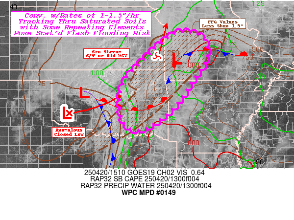
Mesoscale Precipitation Discussion 0149
NWS Weather Prediction Center College Park MD
429 PM EDT Wed Apr 10 2024

Areas affected...Central to Northeastern Gulf Coast

Concerning...Heavy rainfall...Flash flooding possible

Valid 102030Z - 110230Z

SUMMARY...
Heavy rainfall to 2 inches per hour will continue to shift east
down the I-10 corridor into this evening. Widely scattered
instances of flash flooding are possible.

DISCUSSION...
A mature MCV is tracking east along the Gulf Coast this afternoon.
The leading edge of the MCV contains the heaviest rainfall, with
rates locally approaching 2 inches per hour from Eglin AFB (KEVX
radar). These strongest thunderstorms have become more progressive
in the past few hours, which in turn is diminishing the flash
flooding threat as compared to a few hours ago across Louisiana.

Behind the main line of storms tracking east across the Florida
Panhandle, numerous showers and thunderstorms featuring
considerably lower rainfall rates continue from east of Pensacola
west through most of coastal Mississippi. While rates for most
areas barely reach 1 inch per hour, the slow movement of the
parent MCV itself is making for multiple hours of this moderate
rainfall to hit areas behind the initial line of storms. The
result has been numerous instances of flash flooding from
Louisiana to coastal Alabama earlier today. The MCV continues to
draw upon abundant Gulf moisture with PWATs exceeding 2 inches.
Instability has been decreasing along the Gulf coast, generally
under 1,000 J/kg.

As the MCV pushes east, most of the heaviest rainfall behind the
initial line of storms is now mostly off the coast. Much of the
CAMs guidance suggests these heavier cores will either translate
east, eventually impacting the Panama City area, or begin to lift
back north towards the coast, which may impact areas as far west
as Pensacola late this afternoon into this evening. Regardless,
expect multiple hours of moderate to occasionally heavy rain, with
any training cells developing in deep southwesterly flow further
locally enhancing the flooding threat.

Soils in this area started out the day a bit drier than normal,
and with the initial line of storms producing by far the heaviest
rainfall in the entire MCV moving faster to the northeast, think
the broad scale flash flooding threat is now diminishing,
especially the further east into the Florida Panhandle and Georgia
you go. However, the potential for the heaviest rains behind the
initial line of storms to move back onshore into the Florida
Panhandle followed by training cells keeps the flash flooding
threat elevated, especially given the history this MCV has of
producing flash flooding.

Wegman

ATTN...WFO...BMX...LIX...MOB...TAE...

ATTN...RFC...LMRFC...SERFC...NWC...

LAT...LON   31888607 31778441 31478360 31098354 30388384
            30108412 29648515 30298632 30208790 30278912
            30858903 31648773 31828706
Download in GIS format: Shapefile
| KML
Last Updated: 429 PM EDT Wed Apr 10 2024
