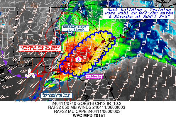
Mesoscale Precipitation Discussion 0151
NWS Weather Prediction Center College Park MD
354 AM EDT Thu Apr 11 2024

Areas affected...Eastern FL Panhandle...Southern GA...Ext.
Southern SC...

Concerning...Heavy rainfall...Flash flooding possible

Valid 110800Z - 111330Z

SUMMARY...Continued broad area of heavy rainfall, rain-rates of
2"+/hr and localized streaks of 2-5" totals in 3-4 hrs may result
in additional isolated possible flash flooding/rapid inundation
conditions through morning downstream of ongoing flooding in
Central FL panhandle/SW GA.

DISCUSSION...As main surface to upper-low start to vertically
stack further NW across the Low Mississippi Valley; a subtle
shortwave has rounded the base of the closed low and is starting
to lift northeast across the central Gulf generally along/ahead of
core of deepening dry slot across S MS, AL at this time.  Combined
with a diffluent weak dual jet streak centered over S GA is
providing highly favorable mid to upper-level ascent pattern.
This is manifesting at the surface with sharpening gradients and
increasing warm air advection across the eastern Gulf pressing
warm moist air further north into central GA with 60-70kts of
850mb flow along/ahead of the dry slot.  This narrowed the deep
moisture plume with 2-2.2" total PWats at the coastline, expanding
to 1.75-2" as far north as central GA.  While lapse rates are
flattening, the strength of isentropic ascent and flux convergence
into ongoing convective clusters will keep rainfall efficiency
fairly high with 2"/hr rates likely through daybreak.

At the surface, the favorable upper-level pattern has supported a
weak surface inflection to develop southwest of Panama City, while
upstream high-falls/dry slot has surged the cold front further
east providing strong directional convergence for some surface
based convection along/near the Big Bend region. Though individual
cell motions are increasing with a ENE trajectory, continued
convergence upstream will support some backbuilding and slow
northward shift in cell motions to allow for repeat/training
streaks to develop across the eastern FL panhandle into southern
GA.  This should allow for some streaks of 2-5" totals to
accumulate.

While the cells/training environment is moving further into
drier/swampier ground conditions, the intensity of the rain from
such moisture flux, may still provide a possible localized
incident or two of flash (or more likely rapid inundation)
flooding through the early morning hours.

Gallina

ATTN...WFO...CHS...FFC...JAX...TAE...

ATTN...RFC...SERFC...NWC...

LAT...LON   32978123 32388041 31698098 30208234 29568321
            29748359 29938396 29938415 30128469 31678342
            32508244
Download in GIS format: Shapefile
| KML
Last Updated: 354 AM EDT Thu Apr 11 2024
