| WPC Met Watch |
|
|
Mesoscale Precipitation Discussion: #0250 (2022) |
|
(Issued at 327 PM EDT Wed May 25 2022
) |
|
| MPD Selection |
|
|
|
|
|

Mesoscale Precipitation Discussion 0250
NWS Weather Prediction Center College Park MD
327 PM EDT Wed May 25 2022

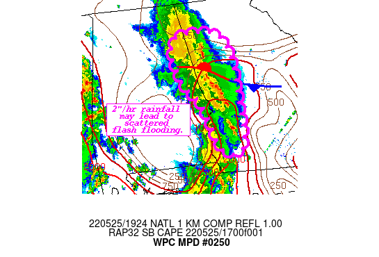
Areas affected...Extreme Eastern AL...West-Central GA

Concerning...Heavy rainfall...Flash flooding possible

Valid 251926Z - 252330Z

SUMMARY...Slow eastward propagating storms with high rainfall
rates will support scattered flash flooding through late this
afternoon.

DISCUSSION...RADAR mosaic imagery and GOES-16 IR imagery depict an
area of intensifying convection ongoing just east of the AL/GA
border. Storms remain oriented along an 850-700 mb confluence axis
and a sharp instability gradient analyzed extending from the FL
panhandle northward, with additional development noted over
southern GA in the higher instability. The convection was moving
quickly north within 30-35 kts of 850-300 mb mean flow, with a
slight eastward motion also noted owing to weak westerly Corfidi
vectors. Current RAP forecasts show a gradually expanding pool of
surface instability and PWAT (2000-2500 J/kg SBCAPE and 1.6-1.8")
ahead of the line and south of a surface front bisecting GA, which
would support maintenance of the complex if it does not outpace
the warm sector. Moreover, the stationary boundary ahead of the
line could facilitate locally enhanced rain rates via
strengthening isentropic ascent atop the front. Recent runs of the
HRRR (while still struggling with timing of the line) lend support
to this scenario with pockets of 2"/hr noted as the line
progresses into GA.

Hydrologically, portions of South-Central AL and Central GA remain
fairly saturated, denoted by NASA SPoRT	soil saturation
percentiles in the 75th-90th percentiles. This combination of
enhanced rain rates atop saturated soils and vulnerable urban
zones could lead to scattered flooding within the highlighted area.

Asherman

ATTN...WFO...BMX...FFC...TAE...

ATTN...RFC...SERFC...NWC...

LAT...LON   34168463 33588417 32438411 31268419 31308480
            32358514 33108568 34088576
Last Updated: 327 PM EDT Wed May 25 2022
|


