| WPC Met Watch |
|
|
Mesoscale Precipitation Discussion: #1143 (2022) |
|
(Issued at 1255 AM EST Sun Dec 04 2022
) |
|
| MPD Selection |
|
|
|
|
|

Mesoscale Precipitation Discussion 1143
NWS Weather Prediction Center College Park MD
1255 AM EST Sun Dec 04 2022

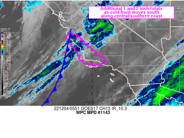
Areas affected...Coastal Ranges of central to southern CA

Concerning...Heavy rainfall

Valid 040554Z - 041500Z

Summary...Rainfall rates are expected to decrease in magnitude
along the CA coast as a plume of moisture translates south through
15Z. Additional rainfall totals of 1 and 2 inches are expected
prior to rainfall coming to an end.

Discussion...IVT values are likely near or just past peak for this
event with 500-600 kg/m/s focused into the Santa Lucia Range of
southern Monterey and northern San Luis Obispo counties as of 05Z.
Earlier observed rainfall rates in the Big Sur region of the CA
coast were in the 0.50 to 0.75 in/hr range near 02/03Z with 12
hour rainfall totals of 3 to 5+ inches ending 05Z.

Looping GOES West infrared satellite imagery showed at least a
temporary lull in colder cloud tops associated with the axis of
greatest moisture flux pointed into the central CA coast but
additional flare ups cannot be ruled out overnight. To the
northwest, an elongated axis of colder cloud tops tied to a
frontal band of rain (ahead of a large closed low centered north
of 40N 130W) was seen to be making steady eastward progress along
the 35th parallel. The eastward push of a shortwave on the south
side of the large closed low to the north should help to support
steady southward progression of the cold front currently analyzed
through Monterey County.

Peak precipitable water values of 1.2 to 1.3 inches and 850 mb
winds of 30-40 kt over the Coastal Ranges are forecast to
gradually wane with time. This combined with the progressive
nature of the low level moisture axis should help to limit
additional total rainfall through Sunday morning. However, 48 hour
rainfall totals of at least 3-5 inches along portions of the
central/southern CA Coastal Ranges have left soils saturated and
the additional forecast of 1 to 2+ inches cannot entirely rule out
the possibility of localized flooding. This would especially be
true for the southern Santa Lucia Range and Santa Ynez and San
Rafael Mountains where orographic ascent will help to boost
additional rainfall totals. As the event wanes late Sunday
morning, hourly rainfall totals are expected to drop to less than
0.25" beyond ~15Z for the entire south-central CA coast.

Otto

ATTN...WFO...LOX...MTR...

ATTN...RFC...CNRFC...NWC...

LAT...LON   36422170 36392154 36252133 36012094 35702068
            35502045 35352028 35091998 34931978 34701948
            34621922 34531908 34251923 34191961 34302037
            34512074 35052097 35442122 35692153 35992173
            36262186 36402181
Last Updated: 1255 AM EST Sun Dec 04 2022
|


