| WPC Met Watch |
|
|
Mesoscale Precipitation Discussion: #0462 (2019) |
|
(Issued at 1236 AM EDT Thu Jun 20 2019
) |
|
| MPD Selection |
|
|
|
|
|

Mesoscale Precipitation Discussion 0462
NWS Weather Prediction Center College Park MD
1236 AM EDT Thu Jun 20 2019

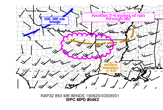
Areas affected...northeastern TX into northern LA and far southern
AR

Concerning...Heavy rainfall...Flash flooding possible

Valid 200435Z - 200830Z

Summary...Flash flooding will remain a concern for the next few
hours across northeastern TX into northern LA and far southern AR.
Training will allow for an additional 2-4 inches across these
areas before overall motions of storms become forward propagating
after about 08Z.

Discussion...04Z surface observations placed an outflow boundary
from western MS into northern LA into northeastern TX between I-20
and I-30. The western portion of the outflow was stalled and being
overrun by 25-30 kt of 850 mb flow from the southwest leading to a
line of strong to severe storms from just northeast of Dallas to
just north of Shreveport. Surface dewpoints in the mid to upper
70s combined with 700-500 mb lapse rates near 8.5 C/km have
contributed to large CAPE values over 3000 J/kg which remain in
place near and south of the outflow boundary. 850-300 mb mean flow
is parallel to the orientation of the outflow across TX and LA and
with low level flow from the southwest, Corfidi Vectors support
forward propagation of MCS movement off toward the southeast.
However, elevated storms rooted closer to 700 mb should train
given westerly flow at this level of 35 kt per area VAD wind
plots, matching or exceeding LFC-EL mean layer winds.

Short term forecasts from the RAP show strong low level
convergence in place over northeastern TX weakening between
07Z-09Z, as 850 mb winds to the south of the outflow boundary veer
with the passage of a shortwave trough currently over central OK.
Continued training of heavy rain, with rates peaking between 2-3
in/hr, is likely in the short term, especially over northeastern
TX on the eastern side of Dallas and near I-20 to the east. An
additional 2-4 inches of rainfall is expected (locally higher)
through about 08Z, at which point a greater forward propagation to
the ongoing cluster of storms is expected to diminish the flash
flood threat.

Otto

ATTN...WFO...FWD...HGX...SHV...

ATTN...RFC...LMRFC...WGRFC...

LAT...LON   33439614 33329395 33179298 32969266 32519256
            31929282 31549363 31429595 32029704 32939709
Last Updated: 1236 AM EDT Thu Jun 20 2019
|


