| WPC Met Watch |
|
|
Mesoscale Precipitation Discussion: #0665 (2018) |
|
(Issued at 419 AM EDT Wed Aug 15 2018
) |
|
| MPD Selection |
|
|
|
|
|

Mesoscale Precipitation Discussion 0665
NWS Weather Prediction Center College Park MD
419 AM EDT Wed Aug 15 2018

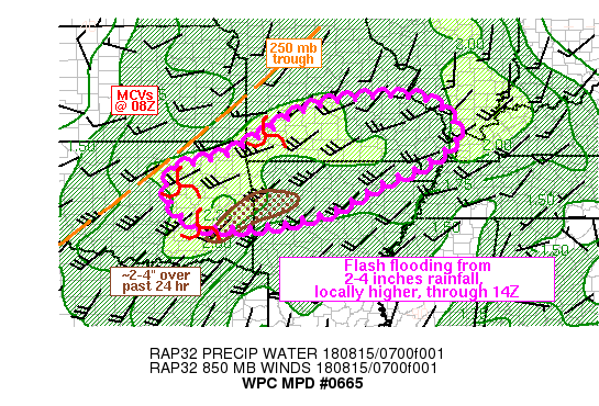
Areas affected...eastern OK, northwest AR, southern MO

Concerning...Heavy rainfall...Flash flooding possible

Valid 150818Z - 151400Z

SUMMARY...An increasing threat for training convection, from
eastern OK into northwestern AR and southern MO, will evolve by
11Z. The potential exists for 2-4 inches of rain by 14Z, locally
higher, which could cause flash flooding, especially if overlap
occurs with heavy rainfall from Tuesday morning near the central
OK/AR border.

DISCUSSION...A complex evolution of storm-scale features has
evolved over the past few hours from the southern Plains into the
Ozarks. At least 3 meso-gamma scale convectively induced
circulations were noted from east-central OK into southwest MO at
08Z, each associated with ongoing clusters of convection and 0.5
to 1.0 in/hr rain rates per area dual-pol estimates. There were
also locally enhanced areas of upper level diffluence/divergence
tied to these storm-scale features, out ahead of a more broadly
defined upper level trough axis that extended from northeast MO
into southwest OK. Precipitable water values varied from 1.7 to
2.0 inches per recent GPS observations from northeastern OK into
southern MO/northern AR amid MUCAPE of 500-1000 J/kg per the 07Z
SPC mesoanalysis page and 06Z sounding from LMN.

Given existing storm motions of 20-30 kt toward the
east-northeast, over time, confluent 850-700 mb flow of 25-35 kt
beneath diffluent/divergent upper levels should help to focus a
couple of areas of training convection from eastern OK/western AR
into southern MO with rainfall rates of 1-2 in/hr. Instability
across the entire region is a bit of an unknown, but given the
moisture present, only weak instability need be present to support
heavy rainfall given enough dynamic forcing from factors mentioned
above. There is good support from the 00Z hi-res models as well as
recent runs of the HRRR for this scenario, with the HRRR focusing
3-6 inches near Fort Smith. Flash flooding will be possible,
especially given possible overlap with 2-4 inches of rain which
fell in the vicinity of the central OK/AR border (including Fort
Smith) since early Tuesday.

Otto

ATTN...WFO...LSX...LZK...MEG...OUN...PAH...SGF...TSA...

ATTN...RFC...ABRFC...LMRFC...MBRFC...NCRFC...

LAT...LON   38169067 37838946 37008919 36798947 36419008
            35889126 35269235 34859402 34809544 34969607
            35479660 36239649 36629510 37069435 37909279
Last Updated: 419 AM EDT Wed Aug 15 2018
|


