| WPC Met Watch |
|
|
Mesoscale Precipitation Discussion: #0160 |
|
(Issued at 633 PM EDT Wed Apr 17 2024
) |
|
| MPD Selection |
|
|
|
|
|

Mesoscale Precipitation Discussion 0160
NWS Weather Prediction Center College Park MD
633 PM EDT Wed Apr 17 2024

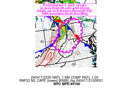
Areas affected...eastern OH, WV, MD Panhandle into western PA and
far western NY

Concerning...Heavy rainfall...Flash flooding possible

Valid 172232Z - 180400Z

Summary...The potential for a quick inch or two of rain may
produce localized flash flood concerns across portions of the
Appalachian Plateau into the central Appalachians through 04Z.
While total rainfall is not expected to amount to much, the region
contains above average soil moisture and elevated creeks/streams
from heavy rainfall within the past 2 weeks.

Discussion...22Z radar imagery across the Upper OH Valley showed a
band of thunderstorms located along and ahead of a cold front
moving through east-central OH. Farther east, thunderstorm
coverage was in the process of expanding near a stationary front
that extended from NW to SE across western PA. The warm sector was
characterized by MLCAPE of 500 to over 1000 J/kg as seen on the
22Z SPC mesoanalysis, confirmed with the 21Z PBZ sounding,
although instability in WV was still below 500 J/kg with the cold
front still well west of the region. Several Wunderground.com
observing sites have reported 0.5 to 1.0 inches of rain in 15
minutes with the line of thunderstorms as they've moved through
over the past 1-2 hours, but the forward progression of the cold
front has limited total rainfall to 1 to 1.5 inches in localized
spots across the area.

Given mean steering flow from the WSW and a tendency for the line
of thunderstorms, south of the apex, to align with the mean wind,
training potential has increased for some locations in central to
southeastern OH. MLCAPE of about 500 to 1000 J/kg is forecast by
the RAP to advance eastward with the progression of the cold front
and some weak instability will remain after sunset, especially
across WV where 0-2 km moisture is expected to remain highest
relative to northern locations. Additional thunderstorm
development will be possible near/south of the southern edge of
the existing line as it moves into WV with possible short term
training resulting in high rainfall intensities over a time frame
of up to 1-2 hours. Northern locations from west-central PA into
western NY may experience two rounds of heavy rain, first with the
ongoing discrete cells and second as the front approaches from the
west after 00Z.

The region from eastern OH into western PA and WV has received 4-8
inches above average rainfall over the last 2 weeks, leaving
portions of the area with increased soil moisture and elevated
waterways. A quick 1-2 inches of rain may result in localized
flash flooding through the early overnight.

Otto

ATTN...WFO...BUF...CLE...CTP...ILN...LWX...PBZ...RLX...

ATTN...RFC...MARFC...NERFC...OHRFC...NWC...

LAT...LON   42517894 42277803 41247762 40127798 39597849
            38308010 38228151 38328192 39018300 39668308
            40498196 41828134 42307991
Download in GIS format: Shapefile
| KML
Last Updated: 633 PM EDT Wed Apr 17 2024
|


