|
Western U.S. convective heavy rain events |
|
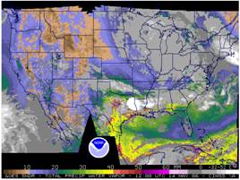
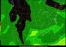
Predicting the rainfall needed for flash flooding in the western U.S. during the warm season is especially difficult since rains of only 2 to 3 cm (around and inch) can produce flash flooding over a small, steeply sloped drainage basin (Maddox et al. 1978). Data coverage is limited due to the how sparse population over much of the west, especially the intermountain region. Also, radar coverage in the west is not as dense as over the east because of beam blockage problems related to the complex terrain. Even where there is radar coverage, the beam may end up overshooting the strongest echoes because the radar is often located on elevated terrain. Therefore, a combination of sensors need to be used to monitor moisture surges and the development of convection. GOES sounder data is available at (http://cimss.ssec.wisc.edu/goes/realtime/grtmain.html) to monitor moisture surges. Note that if you compare the sounder product (below right) to the NAM initial analysis of PW over the Gulf of Mexico at the same time (below left), there appears to be a difference just off the coast of Louisiana. A similar comparison can be made for the gulf of California region during the Monsoon season. Another useful link |
|
NESDIS satellite rainfall estimates also can provide valuable data to supplement radar imagery to monitor and track convective cells and systems in the west during the summer. |
|
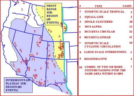
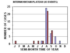
The two figures below are from Chappell’s COMET notes. They show the locations of flash floods over the western U.S and the type of convective system that produced the event. The number of storms near probably skewed by population since if is unlikely that a flash flood would be recorded if it did not impact someone. |
|
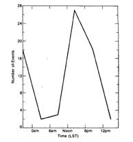
Time of onset of heavy precipitation during western flash flood events (from Maddox et al 1978) |
|
Western events have a strong diurnal maximum during the 6 hour period (2:00PM to 8:00PM LST) and generally occur during the monsoon season of late July through September. |
|
In his COMET notes Chappell identified various types of western flash flood events They differed somewhat from the ones identified by Maddox et al. (1980). Where the composites differ, both sets will be presented. |
|
Maddox type I (western) |
|
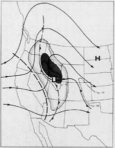
This type event is associated with a shortwave lifting into a mean trough. The shortwave often takes on a negative tilt that acts to increase the upper level divergence over the area where the convection and heavy rain develops. The heaviest rain also usually occurs along or north of a weak surface boundary just west of the 500 ridge axis. The approach of the upper level trough to the ridge axis and associated shortening of wavelength also probably serves to increase the upper level divergence. Maddox and his colleagues caution that there are a number of variations of the pattern and that the amplitude of the ridge and trough do not have to be as strong as in the depiction below. This type system was the most common they found during their study.
The generalized 500-hPa and surface patterns for the type I event is offered below. The figure (at left) includes 500-hPa streamlines, area with the 500-hPa dewpoint depression that is less than or equal to 6oC (scalloped area). |
|
Maddox and his colleagues noted that the interaction between weak shortwaves and surface fronts or troughs was common during these events but that the fronts often did not show up on the NCEP surface analysis. They suggest forecasters do their own analyses.
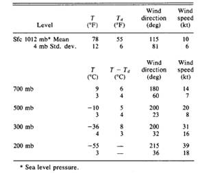
The table above presents the mean conditions associated with this type of event. Deep moisture is present from the surface to 300-hPa. Winds at all levels are relatively light (below 40 kts). Precipitable water averaged .94 inches (184% of the average monthly value) for these events and k indices were 40 attesting to the high relative humidity at 700-hPa.
The elevated terrain over the Rocky Mountains and west helps build a mean ridge over the west during summer. Whenever a trough starts impinging upon this ridge during the monsoon season is a prime period favoring isolated flash flooding in the intermountain region. The low mean precipitable water across this region usually means that heavy rainfall events in the intermountain region have a small scale and sometimes occur from rather scattered convection with most of the convection producing no significant flash flooding while a few isolated cells or clusters of cells produce the flood problems.
A 500-hPa pattern very similar to the one typical of a Maddox type I event often causes heavy to excessive rainfall to the east of north-south oriented mountain ranges. This type of event will be discussed next. |