|
Maddox et al. type II events |
|
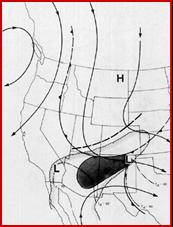
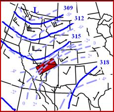
This type of event accounted for about 20% of the western U.S. flash flood cases in the Maddox et al. study. These events are typically associated with a 500-hPa short-wave trough that is moving southward down the eastern side of the long-wave trough. The typical 500-hPa and surface pattern are condensed in the figure below. Note that the threat area (the shaded area) is usually found in advance of the 500-hPa short-wave. During these cases there is almost always a 500-hPa trough of closed low just off the coast of Baja. There is also usually a weak surface low over southern California. These two features help pull monsoonal moisture northward in advance of the southward digging short-wave. The remains of an old frontal boundary is sometimes, but not always, located in advance of the shortwave and is available to help provide low level convergence. |
|
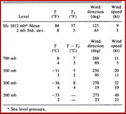
The table (above right) presents the mean vertical profile for some fo the significant levels. Wind aloft are more westerly than for either Maddox type I or IV events. However, speeds are generally light and are often below 40 knots throughout the vertical profile. Surface dewpoints are often in the upper 50s but can be even higher. The dewpoint depressions are low throughout the profile.
The airmass is typically quite moist and unstable with PWs, K indices and LIs averaging an inch (145% percent or normal), 39, -5, respectively.
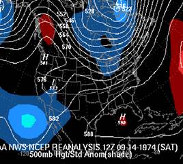
Maddox and his colleagues note that the Sept. 14, 1974 El Dorado, Nevada flash flood could be classified as a type II event. However, though it shows a digging 500-hPa shortwave, the shortwave transitions into a weak 500-hPa low. Therefore, the pattern looks quite a bit different than the composite. |
|
Chappell deformation type heavy rainfall event |
|
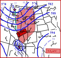
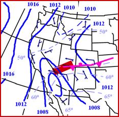
This type of event typically occurs when monsoonal moisture has been pulled northward into the southwest, often but not always in association with an weak upper low to the west or southwest. In that respect this type of event is similar to the Maddox et al. type II event. Like the former, the forcing associated with the southern end of the trough then interacts with the monsoonal moisture. The idealized 500-h-Pa pattern associated with this type of event is provided below (left). Another similarity shared with type II events is a 500-hPA low or trough located near of just off the coast of Baja. The threat area below for flash flooding is near where the entrance region of the upper level jet would be located. The idealized 700-hPa pattern suggests that there is convergence at 700-hPa and that frontogenesis is taking place or that a weak frontal boundary is associated with the trough. |
|
Idealized 500-hPa height , wind and vorticity pattern associated with deformation type flash flood events. |
|
Idealized 700-hPa height , wind and dewpoint pattern associated with deformation type flash flood events. |
|
A weak surface low is often located over Baja or southern California. A weak frontal boundary is also often evident. Precipitable water over the threat is around 1.15 inches (160%) of normal. However, even higher precipitable water is often found across southern Arizona and New Mexico where surface dewpoints are often in the 60s. |
|
Idealized surface pattern for the deformation type events. |
|
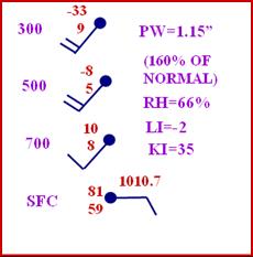
Mean vertical profile for the events. Top number is temperature bottom number is dewpoint depression in oC except for values at the surface which is in oF with the bottom number being dewpoint. |
|
Winds are southwesterly with the profile being very similar to that of the Maddox type II composite. The main difference between the Maddox composite and the Chappell deformation type event, is in the latter, the 500-hPa trough is more progressive than in the Maddox II type composite. Otherwise the events are almost identical. |
|
It is not critical that the pattern exactly fit one the Chappell or Maddox composites.
Here are a few important questions to ask about the pattern.
1) is high (1.00 or greater) precipitable water available nearby that can be tapped? 2) will the airmass be unstable? 3) will the wind shear be on the light side? 4) Will a mechanism such as a shortwave be in place to provide forcing to weaken the cap? |