|
A study by Atallah and his colleagues (2007) composited 14 cyclones that had the bulk of their rainfall occur to the west of the track of the cyclone circulation. Six of the storms made landfall along the Gulf of Mexico west of the Appalachians. Their composite argues strongly that storms that have most of their rainfall distributed on the west side of storm’s track interact with upper level trough and potential vorticity maximum in a synergistic way. |
|
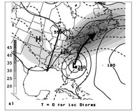
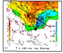
1000-500 hPa thickness (dashed black lines, contour interval=60 m), 1000-hPa geopotential height (solid black lines, contour interval=30 m) and 850-200 hPa wind shear (shaded, contoured every 5 m s-1, starting at 20 m s-1) , for left of track cases. Thick black line is the trough axis. (from Atallah et al, submitted to Mon. Wea. Rev. 2006) |
|
Storms undergoing a transition to becoming extratropical typically have their heaviest rainfall to the west of the track. The 850-200 hPa shear suggests that there was a strong jet streak present to the north or northwest of the cyclone and implies that the storm was located near the right entrance region of a jet streak where frontogenesis is favored. The composite also suggests that the axis of the upper-level trough shifts from having a slight positive tilt or neutral one to having a negative tilt as the storm undergoes extratropical transition (ET). |
|
Agnes illustrates one way in which a tropical storm or hurricane may interact with a trough. If the upper-level trough has a pronounced negative tilt, the hurricane circulation may phase with the trough and be absorbed by the deepening 500-hPa trough. When this occurs, the surface low may re-intensify through baroclinic processes. The surface low also may almost stall or loop as it is pulled into the 500-hPa circulation. Note how the gradient of the isotherms tightens between 0000 UTC and 1200 UTC at 500-hPa and the surface. |
|
From Bosart and Dean, 1991 |
|
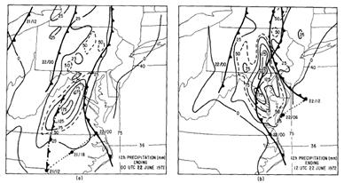
Strong frontogenesis was occurring with the heaviest rainfall located along and to the west of the surface trough associated with the front. The front on the north side of the storm often becomes stationary for a period. This adds to the systems potential to produce an extended period of heavy rainfall. The figure below shows the movement of the front. Note how slowly it moves over Pennsylvania. |
|
From Bosart and Dean, 1991 |
|
Such strong phasing between a tropical system and a strengthening negative tilted mid-level trough to its west is unusual. The 200-hPa analyses above both have red ovals which roughly depict the area where the right rear quadrant of the north-south oriented jet streak is juxtaposed with the left exit region of another jet streak to the south. Uccellini and Kocin (1987) have documented that similar jet streak configurations are conducive to the deepening of east coast snowstorms. |
|
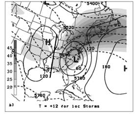
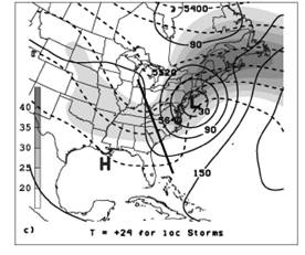
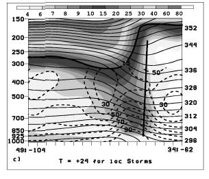
850-700-hPa PV (shaded in cool colors every 0.15 PVU starting at .45 PVU where 1 PVU=10-6Kkg-1 m2 s-1) and 300-200-hPa PV (shaded in warm colors every 1 PVU starting at 2 PVU) and winds (barbs, knots convention). Thick dashed contours indicate areas of positive PV advection in the 300-200 hPa layer. The thick black line represents the axis of cross sections that except for at T+24 are not shown. The arrows define the axis of the upper trough. (from Atallah et al, submitted to Mon. Wea. Rev. 2006) |

|
The potential vorticity (PV) structure for the LOT storms evolves very much like an east coast snowstorm. The upper level PV maximum approached a low level center with each center initially having their own area of PV advection. However, as the distance between them decreases, the advection areas merge together, generally to the north and northwest of the tropical cyclone center. |
|
Cross section of PVU (shaded, starting at .4 PVU as given by the color bar), isentropes (thin solid lines, contoured every 3oK), relative humidity (dashed line contoured every 10%) for line onT+24 shown above . The thick solid line indicates the position of the warm core associated with the tropical system. from Atallah et al, submitted to Mon. Wea. Rev. 2006 |

|
Kocin and Uccellini (2004) have noted a similar evolution of the PV fields during many East coast snowstorms and note the synergistic interactions between the upper level dynamical processes (the PV and jet streak evolution) and the low level diabatic processes in the development of east coast snowstorms. A similar interaction and feedback takes place in tropical system undergoing extratropical transition (ET). |
|
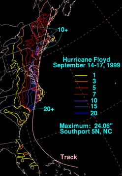
Hurricane Floyd is a classic case where ET is taking place, and not surprisingly, the bulk of its rainfall occurred to the left of the track. |
|
Storms interacting with fronts tend to be some of the wetter storms and can produce heavy rain even as though the remains of the storm may be fairly fast moving. Neither the Kraft rule of thumb or precipitation forecast based on TRaP will work well with transitioning storms. The operational models sometimes handle the precipitation well but at other times do not do a good job. They often have problems in handling the latent heating and associated ridging (Atallah et al, 2006). |

|
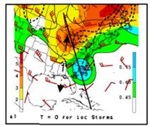
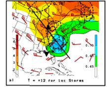
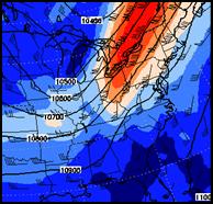
250-hPa winds and heights valid 1200 UTC 16 Sept 1999, the red dot indicates the positions of Floyd |
|
250-hPa winds and heights valid 0000 UTC 16 Sept 1999, the red dot indicates the positions of Floyd |
|
At 0000 UTC, as Floyd moved northward (the red dot on the figure shows its position), a strong positively tilting upper level trough was moving eastward in the vicinity of the Great Lakes and associated upper level jet streak was located to its east. Note that as the upper trough shifted eastward and the distance between the trough and Floyd decreased, the geopotential heights across eastern New England actually rose and the flow across the region became anticyclonic suggesting that the latent heating associated with Floyd was feeding back and was altering the pattern. The half wavelength between the base of the trough and this shortwave ridge was shortening which increased the upper level divergence. This is a fairly common characteristic of storms undergoing extratropical transition.
Another important thing to note about the pattern is the location of Floyd along the right entrance region of the upper level jet streak, one that has a significant along stream variation. The strong along stream variation suggests two things: 1) that the lower branch of the associated transverse circulation will be acting in concert with the low level circulation associated with Floyd to enhance any thermal gradient across the region, 2) will act to increase the upper level divergence across the region. |
|
Precipitation primarily left of Track storms |