|
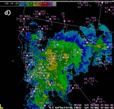
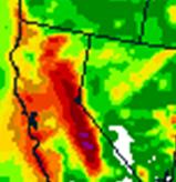
0.50 deg. Reflectivity for 1500 UTC 31 Dec. 2005. |
|
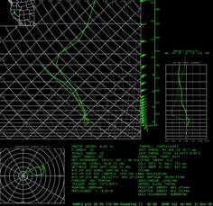
GFS forecast sounding valid 1800 UTC 31 Dec. 2005. |
|
The radar shows that plenty of rain made it east of the mountains by 1500 UTC. Note that the GFS sounding is saturated and pretty much follows the moist adiabatic. Such a sounding looks like it is common for spillover events. Note the lack of any inversion just above the level of the mountain crest. Wallmann suggests that a forecaster look at a cross section with saturated moisture potential vorticity on it to find when the instability or CSI might be present. Model sounding from NSHARP can help. When the forecast sounding looks similar to the one above and strong forcing is present east of the Sierra ridge top, forecast spillover. |
|
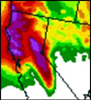
12-36 hr ETA precipitation forecast valid 1200 UTC 31 Dec. 2005 |
|
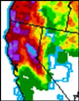
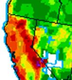
24 hr precipitation analysis forecast valid 1200 UTC 31 Dec. 2005 |
|
The NAM predicted spillover during the Dec. 31, 2005 event but it does not always correctly predict spillover as can be seen below. Spillover events remain a difficult forecast problem. |
|
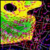
NAM 36hr 850-hPa wind and moisture flux valid 1200 UTC 31 Dec. 2005. |
|
The was associated with an atmospheric river with moisture flux/transport anomalies of greater than 5 S.D. The high snow levels of 8500 ft. led to heavy rains across the Tahoe basin where rainfall amounts of 4 to 8 inches were reported over a 2 day period. 2 to 4 inches fell in Reno. The heavy rainfall led to widespread flooding along the Susan, Pit, Truckee and Carson Rivers. |
|
12-36 hr ETA QPF valid 1200 UTC 20 Oct. 2004. |
|
24-h accumulated precipitation valid 1200 UTC 20 Oct. 2006. |