|
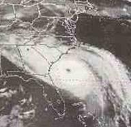
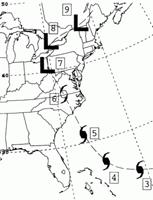
2201 UTC 21 Sept 1989
|
|
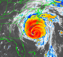
1632 UTC 5 Sept 1996 |
|
Hugo’s track. |
|
Fran’s track |

|
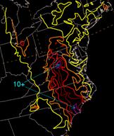
Though Hugo and Fran were fairly similar in size, they produced markedly dissimilar precipitation footprints in part because of the differences in how fast they moved. Fran took two and a half days to track from the Carolina coast to a position near Buffalo, New York. By contrast, Hugo took less than a day to move almost the same distance (see tracks below). This certainly helps explains the differences of rainfall across the Piedmont of the Carolinas during the two storms. |
|
Hurricane Hugo |
|
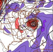
850-hPa geopotental height and RH analysis valid 00 UTC 7 Sept. 1996 |
|
500-hPa height and vorticity analysis valid 00 UTC 7 Sept. 1996 |
|
The NARR reanalysis data below is from The Pennsylvania State University |
|
500-hPa height and vorticity analysis valid 12 UTC 6 Sept. 1996 |
|
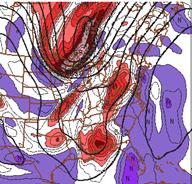
The structure of the storms as they interacted with the mountains is another distinction between the two storms. 500-hPa and 850-hPa geopotential heights are shown for Fran below (the top three panels). Fran still maintained a circulation at 850-hPa that was conducive to maintaining orographic lifting across the mountains of southern Pennsylvania on 00 UTC 7 September. |
|
Hurricane Fran |
|
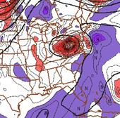
500-hPa analysis valid 12 UTC 22 Sept. 1999 |
|
500-hPa analysis valid 00 UTC 23 Sept. 1999 |
|
850-hPA geopotential height and RH analysis valid 00 UTC 23 Sept. 1999 |
|
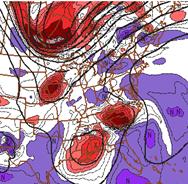
Hugo’s 500– and 850-hPa patterns are shown on the three bottom panels. Hugo was actually stronger than Fran at landfall but quickly lost its closed circulation at 500– and 850-hPa as it interacted with the strong trough digging into the Great Lakes region. The lack of strong easterly flow by 00 UTC 23 Sept. limited the vertical motion as the flow quickly shifted to having a westerly component across the mountains which causes downsloping flow east of the mountains. Hugo is a cautionary tale showing that a storms interaction with synoptic scale trough does not always result in a large areas of heavy rainfall associated with isentropic lift and frontogenesis. In this case the shearing of the circulation center, the rapid movement, and the lack of a strong frontal boundary nearby kept Hugo from producing widespread heavy rainfall. |
|
Hurricane’s Hugo and Fran, a quick comparison |
|
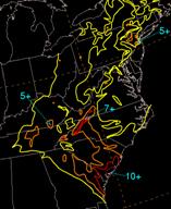
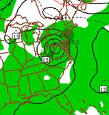
Hugo storm total rainfall |
|
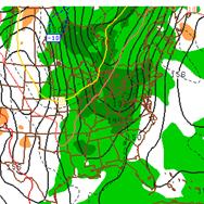
Fran’s storm total rainfall |