|
Convection and Mesoscale convective systems (MCSs) |
|
Convective systems (MCSs) come in many shapes and forms and models often have a hard time forecasting them and their associated precipitation. To correctly predict the precipitation associated with an MCS, a model has to correctly forecast: 1) the timing and location of the onset of convection (the initiation of convection), 2) the convective system evolution (including mode of development, the size of the convective system, how it will be effected by propagation and duration of the system), 3) the rainfall rates associated with the system which may vary across the MCS and may fluctuate with time, 4) the impact on other downstream weather elements such as clouds and temperatures which may in turn impact on the vertical temperature structure and therefore the stability of the atmosphere.
Maddox (personal communication) has stated that if a forecaster or model messes up forecasting the initiation of convection (when and where it forms), there is little hope of forecasting the resultant convective system or its associated weather correctly. There are a number of reasons why mesoscale models have problems predicting initiation of convection. One obvious problem is the lack of sufficient observations to accurately depict the initial state of the atmosphere. This is especially true of measurement of the horizontal and vertical distribution of moisture, both of which modulate the stability of the atmosphere. A second problem is that a number of atmospheric processes occur at scales below the scale that mesoscale models are capable of resolving. The most obvious example is convection. All convective parameterization schemes have weaknesses (Gallus 1999). Their prime purpose is to keep the mesoscale model from suffering from grid scale convection which can feedback erroneously into the model mass and wind fields. These parameterization schemes have problems simulating outflow boundaries and do not include sophisticated enough microphysical processes to correctly simulate the rear inflow jet.
During past decade, a number of researchers have undertaken studies in hopes of improving warm season precipitation forecasts. Stensrud (1999b) illustrated that there was a need to improve the initialization of such mesoscale features as cold pools. However, Gallus and Segal (2001) showed that various methods to improve mesoscale initiation did not consistently improve QPF. At first glance, using ensembles to assess probabilities offers for various precipitation thresholds. However, studies have shown that the early SREF ensemble runs had insufficient spread (Hamill and Colucci 1998), probably because they were based on perturbing initial conditions which during the weak flow of summer did not typical grow fast enough (Stenrud et al. (2000) to encompass all the possible solutions. In the latter article, the authors discussed that the physics and initial conditions have to be varied in ensemble forecasting. NCEP introduced physics uncertainties into the SREF in 2004 (Du et al. 2004) by varying the convective parameterization schemes. However, the members still tend to cluster around the convective scheme rather than truly dispersing.
A study by Jankov et al. (2005) looked into varying model physics in additional ways to study the impact of various physics packages on the WRF QPF. They found that no one model configuration was clearly superior in all cases and that varying how convection was handled led to the most significant differences in the forecasts. They also noted that the rainfall rate was typically highest when no convective parameterization scheme was used. Threat scores for all model formulations was low for the higher thresholds of precipitation. For the foreseeable future, forecasters will continue to be an important element in predicting heavy convective rainfall events. |
|
A number of researchers have noted the importance of convection and especially, mesoscale convective systems in producing warm season precipitation. Heideman and Fritsch (1984) estimated that about half of warm season precipitation over the United States is produced directly by mesoscale systems or phenomena. Fritsch et al., in a study of long lasting, circular shaped, convective systems, using satellite imagery found that such systems accounted for approximately 30 to 70% of warm season precipitation between the Rocky Mountains and Mississippi River.
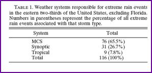
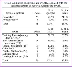
More recently, Schumacher and Johnson (2005) examined the synoptic and mesoscale structures of extreme rainfall events over the eastern two thirds of the U.S. using radar imagery. They defined “extreme rainfall” as the 24 hour precipitation amount that exceeds the 50-yr recurrence interval amount at that point. They noted that 65.5% of extreme events were associated with MCSs and that 26.7% were associated with synoptic scale systems. However, the latter figure may be misleading since they noted that for synoptic systems, over 90 percent of the extreme rainfall events were associated with convection. In other words, 97.2% of all “extreme” rainfall events were associated with convection. |
|
From Shumacher and Johnson, 2005 |
|
Therefore, understanding what governs the development of convection and convective systems is essential for forecasting heavy to extreme rainfall events. |
|
Heavy rainfall typically occurs with moist deep convection. Doswell et al. (1996) have said that in order to produce moist, deep convection three ingredients are needed: 1) the environmental lapse rate must be conditionally unstable, 2) there must be enough lifting so that a parcel will reach its level of free convection, 3) there must be enough moisture present that a rising parcel’s associated moist adiabat has a level of free convection.
“Nothing can replace an examination of an individual sounding” according to Doswell (1982). Soundings are the best tool to look at the depth of the moisture, the CAPE, CIN, LFC, LCL and Equilibrium level and for estimating what the cloud base will be. We’ll assume that forecasters understand how to read a sounding. Besides using CAPE calculated from soundings and model soundings to assess instability, forecasters at HPC also often look at Lifted and K indices. The latter gives an indication of the depth of the moisture. It is also important to remember that the stability can be changed by diurnal heating, differential advection of moisture and temperature, vertical motion and or differential vertical motion.
While there is a clear association between large scale lift and convection, synoptic scale lift usually is not sufficient to release convective instability. Instead, it plays a role in steepening the lapse rate and decreasing the convective inhibition or cap. By contrast, mesoscale lifting produces near surface low level convergence that forces the moist boundary layer air upward, when the moisture and low level convergence is sufficient for a parcel to reach its LFC, convection occurs.
Typical sources of mesoscale lift include: fronts, orographically induced convergence zones, sea breeze boundaries, dry lines and outflow boundaries and even land use boundaries. Therefore, it is important for a forecaster to analyze surface, upper air data and radar and satellite imagery closely for possible mesoscale features that might provide lifting.
Moisture helps modulate the cap and whether the parcel can reach its LFC. Available moisture also helps determine how much moisture will be available for a thunderstorm to process. The higher the influx of moisture into a convective system, the more potential it has to produce high rainfall rates. However, there are other factors that also modulate how much rainfall a system will produce. These factors will be discussed later in the manual. |