|
The NAM model |
|
The NAM model no longer uses the eta coordinate system and instead used a hybrid sigma coordinate system. There are a number of advantages to the new coordinate system, see http://www.meted.ucar.edu/nwp/pcu2/namvcoor1.htm
The one disadvantage is that use of a terrain following scheme near the surface typically results in the scouring of cold air to the lee of the mountains and insufficient blocking of the flow directed towards the mountains. Such blocking is an important mechanism in cold air damming. Another recent change to the NAM model has been the introduction of the Ferrier cloud and precipitation parameterization scheme. This method is a more complex parameterization scheme than the NAM used previously but is still not considered a complex scheme. However, now has for different classes of hydrometeors, mixed clouds, large ice (snow, grapple and sleet), small ice (suspended cloud ice). It also allows for the vertical advection of the total condensate but does not advect different classes of condensates separately. The scheme also allows for both warm and cold rain processes.
The scheme does not adequately handle some phenomena. For example, heavier precipitation rates associated with rapid dendritic crystal growth. Also, it does not allow crystal growth where an inversion is present and instead actually has the crystal shrink slightly. The differences in the droplet spectrum between continental and marine airmass are not adequately handled. Even when knowing of these shortcoming of the scheme, it is difficult for a forecaster to judge their impact on individual precipitation forecasts.
Convective parameterization scheme currently employed in the WRF/NAM is the Betts-Miller-Janjic (BMJ) scheme. When the parameterization scheme kicks in it uses reference vertical temperature and moisture profiles with thermal profile similar to that of the moist adiabat and with dewpoint depressions of 4 to 6oC. The following website explains the reference profiles, http://www.meted.ucar.edu/nwp/pcu2/etacp3.htm.
The scheme only triggers when there is an unstable layer in the lowest 200 hPa above the ground and the convective cloud depth is at least 200 hPa. The adjusted profiles must produce warming and drying and the pre-convective precipitable water in the cloud layer must be higher than the precipitable water in the adjusted reference profile. Therefore, the NAM often has problems forecasting elevated convection.
It’s important to remember that convective parameterization schemes were not developed to produce true convective rainfall rates but were developed to keep models from producing convection on the scale of a grid box. Such grid scale convection would to significant erroneous feedback into the mass and wind fields of the models. Rather, the precipitation produced by a parameterization scheme is a by-product of the scheme.
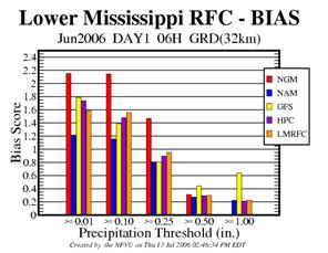
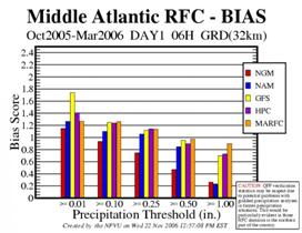
The classic severe weather sounding with a dry mid layer may not trigger the scheme as the precipitable water in the cloud layer may not exceed the precipitable water of the adjusted reference profile. The scheme convects even if a cap is present. The scheme activates when some low level CAPE develops but activate before the convective temperature is reached. This leads to the model forecasting convection too early in the day. This may explain why the WRF/NAM tends to have a high bias for lighter thresholds of rainfall but a very low bias for higher ones across the south during summer. This low bias for heavier amounts seems to occur more often where synoptic scale forcing is weak. By activating too early, the scheme prevents high CAPE from building up in the model sounding later in the afternoon. Note the low bias for June across the Lower Mississippi valley area of responsibility.
|


