Early Nineteenth Century
August 29, 1803: The schooner Jupiter
sprung a leak off the Virginia Capes in heavy seas during a storm off
the Virginia Capes, before heading into the Chesapeake. As the ship was
sinking, the captain jumped overboard, but was pulled into the whirlpool
created by his sinking ship and drowned (Chapman).
September 8, 1804 (Antigua-Charleston Storm):
This system was first spotted near the Northern Leeward Islands on
the 3rd and moved west-northwest, to very near the Florida coast.
It then moved inland near Charleston with disastrous consequences, before
moving northeast along the coast of the Atlantic Seaboard.
October 9, 1804 (New England's Snow Hurricane
of 1804): At Norfolk, winds shifted from Force 3 southwest (on the
Beaufort scale) to Force 6 northwest by 2 p.m.. A schooner Rising Stakes,
off Cape Henry, went through the "dreadful squall" at 11 a.m.. The system
passed through Chesapeake Bay, then inland between Philadelphia and Atlantic
City before moving onward to New York City and Boston. Eight perished offshore.
As it passed through the Northeast, it became
a nontropical low as cold air rapidly enveloped the circulation of the
cyclone. Snow fell from the hills of Connecticut northward into Canada.
As much as 24 to 30 inches of snow fell in the Berkshires of Massachusetts...which
in a wet snow could be approximated to six inches or more of liquid precipitation.
This was the first reference to snow involved with a landfalling tropical
cyclone, but not the last, as the reader will see later on in this history.
August 21-23, 1806 (Great Coastal Hurricane
of 1806): The appearance of the weather from the 20th indicated
a nearby storm. Heavy squalls broke upon the bar off Norfolk. A hurricane
which went inland in South Carolina took 36 hours to go through North Carolina.
The system accelerated into the offshore waters of Virginia.
A gale developed out of the north-northeast on
the 22nd before noon. At Norfolk, the wind blew with "great
violence" out of the north between midnight and 3 a.m.. A considerable
amount of rain fell. A "long and uncommon" drought in Petersburg was ended
by the cyclone (National Intelligencer). This saved the corn crop.
Several new buildings and chimneys were blown down. Two vessels were grounded.
The hurricane caught British and French ships
off guard, while engaged in the Napoleanic Wars in the U.S. shipping lanes.
The British man-of-war L'Impeteax drifted under jury masts for 23
days before finally beaching near Cape Henry. The ship Atlantic and
brig Martha Bland were driven ashore. The vessels Haleyon, Hope,
and the Revenue cutter schooner Eagle went ashore at James Island.
Ships of the two warring nations put in for repair
and refitting at the port of Norfolk after the storm. This hurricane, due
to its slow movement and consequent erosion of the coastline completed
the creation of Willoughby Spit. A seawall built to prevent further erosion
at Smith Point lighthouse was damaged.
September 28-29, 1806: The first signs
of the system were seen in Georgia, when several days of heavy rain fell
at Augusta, Georgia on the 25th (National Intelligencer). Gales began
from the northeast during the night of the 28th at Norfolk.
Winds became southeast in the morning before shifting to the west, as the
center moved inland of the coastline. Tides rose "uncommonly high". The
schooner Charming Mary fell victim four leagues north of Chincoteague,
with many of her masts seen above the waterline after her sinking (Chapman).
September 12, 1808: A hurricane again damaged
the seawall surrounding Smith Point lighthouse. The ship Mary was
destroyed during the gale, while anchored at Baltimore.
August 27-28, 1813: A hurricane struck
Charleston and spread gale force winds as far north as Maryland. An all-day
easterly gale was seen in the Upper Chesapeake Bay on the 28th.
A north-northeast wind began on the 27th. By 10 p.m., it shifted
to southeast, accompanied by squalls. As winds became southwest, strong
winds buffeted the region until 1 a.m. the 28th. By 11 a.m.,
winds were dying and the sun was shining once more. The U.S. schooner Carolina
went ashore near James Island.
The War of 1812 was in progress. A large prison
ship, with 50 passengers aboard composed of the British schooner Dominico,
parted cables and was driven into the marsh of James Island by the
gale (Chapman).
August 24-25, 1814 (Burning of Washington):
A very hot day accompanied the retreating of Federal troops from the
Capitol. As Dolly Madison and an armed escort stopped in Tennallytown
(Tenlytown) during their retreat, a strong wind accompanied by dark clouds
rolled over Washington county. Winds near hurricane force and a prolonged
downpour added to the drama of the day. The rains were helpful, as
they helped firefighters quench the fires set by the British (Helm).
The weather signs mentioned point to this either being a severe thunderstorm,
or a tropical cyclone.
October 24-26, 1815: On the 18th,
a powerful hurricane struck St. Bartholomew in the Caribbean Sea. By the
24th, it progressed west and northwest to a position east of
Chesapeake Bay. The schooner Friendship was knocked on her beam
ends by unfriendly winds and seas. For 48 hours, the storm passed offshore,
delaying ship arrivals into Norfolk with its strong northwest wind (Chapman).
September 18, 1816: A tropical storm affected
Virginia before moving northeast into New York. Heavy rains caused the
James river in Richmond to rise only an inch or two lower than the High
Fresh of 1814. Flood waters invaded the first floors of area homes. One
bridge was submerged, cutting off travel (Chapman).
August 8-9, 1817: A tropical storm with
heavy rain moved through the state. At Norfolk, floods to the north delayed
the passage of mail. The gale moved slowly northeast, reaching New York
on the 12th. (Chapman)
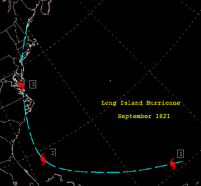
| September 2-3, 1821 (Long Island Hurricane):
A fast moving hurricane traveled from Puerto Rico to Norfolk in only
two days. The storm passed by Turks Island in the Bahamas on the 1st.
This hurricane moved inland near Wilmington, North Carolina the following
day. The center then tracked west of Ocracoke but east of Edenton. In Currituck,
N.C. all but a half dozen houses were destroyed and several people killed. |
 |
It was a "tremendous storm", causing great wind damage
and damaging ships in the harbor. At Norfolk, rains began at 6 a.m.. By
8 o'clock, a northeast gale ensued and increased in intensity to hurricane
force by 11:30. By 12:30 p.m., rains ended; conditions were beautiful by
mid afternoon.
An account from the Norfolk Herald described the
storm as such.....
| From half past 11:00 until half past 12:00, so
great the fury of the elements, that they seemed to threaten a general
demolition of everything within their reach. During that period the scene
was awful. There was the deafening roar of the storm, with the mingled
crashing of windows and falling of chimneys, while the rapid rise of the
tide threatened to inundate the town. The continuous cataracts of rain
swept impetuously along darkening the expanse of vision and apparently
confounding the heaven, earth and seas in a general chaos; together with
now and then a glimpse caught through the gloom, of shipping forced from
their moorings and driven with rapidity, as the mind might well conjecture
in such a circumstance to inevitable destruction. (Ludlum) |
Trees were uprooted. Part of the front of the
Episcopal church was blown in; its organ left in ruin. The courthouse was
partially unroofed. Several new homes suffered complete destruction while
many others experienced damage. The new stone bridge on Granby Street was
damaged by the incessant banging of heavy timbers against it. The tides
inundated the ground floors of all the warehouses on the wharf lining the
Elizabeth River. The waters surged as far inland as Wide Water Street some
several hundred yards from the river. The surging waters of the Elizabeth
River swept away the bridge on Catherine Street. The drawbridge across
the Elizabeth river was swept away. The U.S. Frigates Congress and
Gurriere were grounded while numerous other brigs, schooners, and
smaller ships suffered an untimely demise.
Crops were destroyed in the vicinity of Chesapeake
Bay. At Chincoteague, waters surrounding the island were evacuated such
that miles of sandbars lay exposed to the air, as winds were initially
offshore. The following is an account of what happened next from Howard
Pyles, written in 1876:
| "...then a dull roar came nearer and nearer,
and suddenly a solid mass of wind and rain and salt spray leaped upon the
devoted island with a scream. Great pines bent for a moment, then, groaning
and shrieking, were torn from their centuried growth like wisps of straw
and hurled one against another; houses were cut from their foundations
and thrown headlong; and then a deeper roar swelled the noise of the tempest,
and a monstrous wall of inky waters rushed with the speed of lightning
toward the island. It struck Assateague, and in a moment half the land
was a waste of seething foam and tossing pine trunks; and the next instant
it struck Chincoteague, and in an unbroken mass swept away men and ponies
like insects; rushing up the island, tearing its way through the stricken
pine woods." (Barnes & Truitt) |
At Pungoteage, a ten foot storm surge led to "unexampled
destruction". Damage spread north with the storm into New York and New
England over succeeding days. It was considered one of the most violent
hurricanes on record... with damage totaling $200,000 in Virginia. Five
drowned at Chincoteague.
September 27-28, 1822: This hurricane struck
Charleston, then moved through central North Carolina and western Virginia,
accompanied by a "tropical deluge". Richmond had endured a long drought
until this storm visited the region. "Very copious rains" and "equinoctial
winds" quickly ended the drought. Flash flooding occurred on the
James River, rising feet in depth in a matter of one hour (Washington Gazette).
Mail south of Richmond was unable to be delivered for three days, as the
storm rendered roads impassable. At Monticello, near Charlottesville, Thomas
Jefferson's granddaughter noted that a violent storm broke branches and
felled one of their willows. At Lynchburg, winds uprooted trees and toppled
chimneys. Along the Staunton River, rains began on the 27th
and continued until 9 a.m. the next day. The river rose to "the greatest
height ever known" (Chapman).
June 3-4, 1825: Forming before what is
nowadays considered as the beginning of the hurricane season, a severe
tropical storm tormented the Atlantic seaboard from Florida to New York
City. It was first sighted near Santo Domingo on May 28th and
moved across Cuba on June 1st. Gales began at St. Augustine
as the cyclone approached U.S. soil on the 2nd, and at Charleston
on the 3rd.
It raked Norfolk with "undiminished violence"
for 27 hours from the morning of the 3rd, as the storm passed
by to the east. The wind came in "flaws". Trees were uprooted. At noon
on the 4th, stores on the wharves were flooded up to five feet
in depth. High winds howled through Washington D.C.. Along with a cold
rain, winds leveled crops. The storm then moved northeast past Nantucket
on the 5th.
An account of the storm was given by Ann Waller
Tazewell, wife of the then governor of Virginia in a letter to her son.
She describes the storm as such
| "....The rain commenced on Friday morning
(3rd), and continued pretty steadily all day, at night the wind
blew so hard that this house rocked considerably. I was so much alarmed
as to be unable to sleep but very little - I thought of my flowers, but
could not expect anyone so much as to look after my cows or anything, as
the rain fell in torrents, and the wind came in flaws, which made it like
thunder yesterday (4th) the storm continued until five in the
evening, there was a strong northwest wind all day, and the highest tide
I ever saw in my life. The wind and tide together tore down all our enclosures
at the other lot, upset our cow-house and then dashed it to pieces, tore
up some of the wharf logs, upset the Temple there, and drifted it into
the flower garden........We sat at the front windows witnessing the destruction
all the time it was going on. Our front lot was two thirds covered by the
tide. Some vessels that we saw pass rapidly by, were driven ashore at the
Hospital Point (Portsmouth)........" |
Ann Tazewell later compares the storm to the great
gale of September 1821 in this following passage: "....Such a storm was
never experienced here before, by anyone that I have heard speak of it.
It is thought to have been far worse than the September gale of 1821."
Mrs. Tazewell's letter also mentions that they could not prepare dinner
since the tide level was even with the kitchen floor.
An account of the storm as given by the Norfolk
and Portsmouth Herald described the storm as such. It is interesting to
note the contrasting opinions between the Norfolk and Portsmouth Ledger
and the letter from Mrs. Tazewell regarding the comparisons between this
storm and the September gale of 1821
| .....It is uncommon to hear of violent storms
and hurricanes on any part of our extensive coast in the month of June;
but we have to notice a visitation of stormy weather, which commenced about
9 o'clock on Friday night (3rd), rarely if ever equaled within
the life span of the oldest inhabitant. The storm of the 3rd
of September 1821 was perhaps more violent but it only lasted three or
four hours, while this storm continued with undiminished violence, from
the hour we have stated until 12 o'clock on Saturday night (4th),
or about 27 hours. The wind at the commencement of the storm was northeast
and so continued until about 12 o'clock on Saturday, when it began to haul
gradually to the northwest and westward, and held up at southwest.... |
According to this account, the tides in this storm
were higher than those in the September gale of 1821.
| ....considerable damage was done by the
high tide which rose at least eighteen inches higher than it was known
to be within the last forty years. The highest pitch of the tide was at
12 o'clock on Saturday, at which time the stores on the wharves generally
were inundated from the depth of three to five feet, and the water extended
up to the doors on the north side of Wide Water Street. The whole Town
Point to within a few feet of Main Street was over-flown, as also was that
part of town extending eastward from Market Place to the Drawbridge, the
water rising considerably above the line of Union Street. In most of the
stores on the wharves, all articles liable to be damaged by the tide were
found (too late for remedy) that the precaution was unavailing in consequences
of the unusual rise of the tide, and the articles were of course damaged.... |
August 24-27, 1827 (St. Kitts Hurricane): A
hurricane originating near the Windward Islands struck Cape Hatteras, before
moving northeast offshore Virginia, Maryland, and New England. The track
of this storm was to the east of Norfolk. Initial reports from Wilmington,
N.C. indicated that this was a storm of great intensity as it passed by
to their east. One report gave an account of waves over the top of garden
fences some 6900 feet from the beach. Other reports indicated storm tides
greater than 10 feet above normal levels. The town of Washington,. North
Carolina, on the western end of Pamlico Sound, reported water levels 12
to 15 feet above ordinary levels.
The following first hand account of this storm
in Virginia was from the Tazewell Papers in the Virginia State Library.
Henry Tazewell wrote to his brother John in New York and described the
storm as such.
"....A severe gale which continued for three days
changed the climate here entirely and persons are clad generally in full
suits of winter clothing; the same gale has done great injury to shipping
and to present crops. The fodder is worthless and the corn
in many places is much broken by the wind."
The Norfolk newspapers, The American Beacon and
The Norfolk Herald reported little in the way of tidal damage in this storm
due to an ebb tide. There was much less damage to property in the area
than in the memorable 1821 gale, but this storm was almost as violent as
that gale.
Both papers reported a gale of wind which was
accompanied by a copious fall of rain. The gale
"...commenced in the forenoon of August 25th
and continued to increase until the evening, when it blew tremendously.
About midnight, the rain ceased and the gales somewhat abated, though it
continued to blow fresh all day on the 26th."
At the height of the storm, winds unroofed a two
story building on Talbot street in Norfolk and commenced to blow away the
second floor of the building. Livestock was swept away in large numbers.
Corn was leveled at Belleview...a mill dam was torn to shreds and the bridge
over it was swept away. The sloop Flag capsized on the Middle Ground
of the Chesapeake; the vessel had no survivors. The brig Liberty of
Boston broke away and drove itself ashore, on the south side of Portsmouth.
The schooner Mulberry saw its bow stove in, shrouds and jib-stay
carried away, and jib torn off while off Common's Marshes. A "considerable
quantity" of cargo was thrown overboard to prevent it from sinking.
"Considerable mischief" was caused by the tempest as far north as Baltimore.
August 26-29, 1829: A tropical storm of
considerable strength moved northward through eastern North Carolina and
Virginia, accompanied by a tornado near Sunbury, North Carolina in Gates
County. Torrential rains were reported in Norfolk. At Georgetown, the rice
crop experienced great injury. Santee also saw damage. A vessel
fifty miles east of Chincoteague was dismasted. The American Beacon reported
the following account from this storm.
"....The earth is completely saturated and the
grounds covered in water, while the roads, in many places, are rendered
impassable by the rise of the water courses." (Chapman)
August 16-18, 1830 (Atlantic Coast Hurricane):
This hurricane passed northeast of the Caribbean Sea and tracked west
north-west to a point very near Daytona Beach, Florida before recurving
to the north and northeast. The center made landfall on the morning of
the 16th near Cape Fear and moved back out into the Atlantic
by nightfall. The area's three-month drought came to a sudden end. Complete
damage was done to corn crops as a considerable amount of rain fell.
A number of ships that arrived at Alexandria on
the 22nd spoke of a severe gale on the 18th...one lost its topsail.
The schooner Dove, while thirty miles east of the Virginia Capes,
experienced a severe hurricane and lost most of her upper works.
On the morning of the 19th, an empty ship in full sail was seen just off
the Virginia coast.
August 24, 1833: As a rare act of foreshadowing,
a northeast gale detained around 100 vessels at Norfolk. This system passed
well off of the Virginia coast. Unlike the storm exactly a century later,
no damage was reported (Chapman).
September 5, 1834: A hurricane that struck
the North Carolina coast also created problems for Virginia. A "severe"
northwest wind capsized the schooner E. Pluribus Unum, laden with
stones. The crew escaped with their lives. The schooners Susan and
George Wheaton bumped into each other at Newport News. The Susan's
upper work was carried away (Chapman).
August 18-20, 1837 (Calypso Hurricane): A
hurricane which skirted the North Carolina Outer Banks also affected Virginia.
Damage was considered lighter than at Wilmington, where bridges washed
out during the storm. This was referred to as the worst storm in Norfolk
since 1822. The storm was observed east of the West Indies on the 13th,
moved into the central Bahamas on August 16th and began to affect
the North Carolina coast on the 18th, where the Norfolk newspapers
reported it had continued with unusual severity for forty-eight hours.
The Norfolk-Herald offers this account of the
storm.
| "....One of those cracking northeasterly blows
commonly called "September gales" which, however, more frequently visit
our coast in August commenced here on Saturday the 19th, but
as our harbor is completely sheltered "land-locked", we believe the sailors
call it, none but the weather-wise had any idea that it was blowing a gale
outside, until 11 o'clock at night, when the symptoms of a regular-built
gale were easily recognized in the roar and rustle which it kept up, and
the splashing of the torrents of rain which it drove before its streamed
flows. This strife of elements continued until 12 o'clock Sunday the 20th,
when the wind hauled around to the northwest but without clearing off and
continued to blow a heavy gale from that point, accompanied with rain the
remainder of the day." |
The American Beacon offers this account of the
storm.
| "....The weather on Saturday morning (19th)
indicated a gale. It commenced raining that morning and continued but with
little intermission, until about 3 p.m. the next day. The wind blew fresh
from the northeast all day Saturday, and at night increased to a gale,
blowing down fences, trees, chimneys and prostrating the corn....In walking
the streets after the storm, it was melancholy to see some of the stoutest
trees prostrated. The tide is very high." |
October 8-9, 1837 (Racer's Storm): This
hurricane was named after the British sloop-of-war, the H.M.S. Racer,
which encountered it on September 28th in the central Caribbean
Sea. It was the tenth known storm of that destructive season. After moving
northwest into the far western Gulf of Mexico, the storm slowly recurved
along the coasts of Texas and Louisiana before it struck Venice, Louisiana
on the 7th.
The system then passed back out into the Gulf
before making a second landfall near Pensacola late on the 7th.
The storm moved northeast and went off the East Coast near Wilmington late
on the 9th. Norfolk experienced a northeast gale on the 8th
and 9th. This prevented steamboats from leaving their docks.
August 29-30, 1839: A tropical cyclone
which struck Charleston on the 28th passed through eastern North
Carolina on the 29th and then Norfolk just past midnight that
night. The hurricane raged until 3 p.m..
October 3-4, 1841: An intense hurricane
raced through the shipping lanes offshore the Mid-Atlantic. On the
western fringe of the cyclone, several ships were beached at Cape Henry.
The system went on to devastate eastern New England, when cold air encircling
the increasingly nontropical storm led to "a violent storm of snow and
sleet" at New Haven, Connecticut.
September 8, 1846: This hurricane created
Hatteras and Oregon Inlets.
October 12, 1846 (Great Havana Hurricane):
The Great Havana Hurricane struck the Florida Keys with great violence
before moving northward, inland of the Eastern seaboard. It destroyed the
Old Key West lighthouse; fourteen inside the structure perished (DeWire).
The Potomac at Alexandria and Washington D.C. reached its highest heights
in 20 years. Tides at Washington, D.C. rose to 6.9 feet above low water
datum. Extensive damage was seen as far north as Baltimore, Philadelphia,
and New York.
July 18, 1850: The first of three hurricanes
to affect the upper Eastern Seaboard moved into North Carolina on the 18th.
As it moved north, Chesapeake and Delaware Bays took a beating as high
waves and tides flooded the coast. It moved almost due north into central
New York state.
August 24, 1850: A powerful Gulf hurricane
struck Apalachicola on the 24th; a great storm surge inundated
the northeast Gulf coast. As the system moved north, enormous amounts of
rain fell from Georgia northward to Virginia. Major flooding occurred along
numerous rivers. The Dan rose to a level twenty feet above normal. The
cyclone continued northeast, causing damage in its wake through New England
(Barnes II).