A tropical wave emerged from western Africa
on 4 August. Radiosonde data from Dakar showed
that this wave was
accompanied by an easterly jet streak of around 65 mph near the 650
mb level. The
wave also produced surface pressure falls on the
order of 5 mb over 24 h near the west coast of Africa.
On satellite
images this system was not particularly impressive just after
crossing the coast, since it had
only a small area of associated
deep convection. As the wave progressed rapidly westward across the
tropical Atlantic, the cloud pattern gradually became better
organized, with cyclonic turning becoming
more evident in the low
clouds. The first center position estimates were in the vicinity of
9-10°N, 47°W
on the evening of 7 August. Curved banding of the deep
convection
became better defined over the
ensuing 12 h, and this, along with
surface observations from the southern Windward Islands, indicated
that a tropical depression had formed by the morning of 9 August,
centered about 100 n mi south-
southeast of Barbados.
Late on 9 August, the depression moved into
the southeastern Caribbean Sea. A strong deep-layer high
pressure
area to the north of the tropical cyclone induced a swift
west-northwestward motion near 25
mph. With low vertical shear and
well-established upper-level outflow, the depression strengthened
into Tropical Storm Charley early on 10 August. Fairly steady
strengthening continued while the storm
moved into the central
Caribbean Sea, and when Charley approached Jamaica on 11 August, it
became
a hurricane. By this time, the forward speed had slowed to 16
mph. Charley's core remained offshore
of Jamaica; the
center passed about 35 n mi southwest of the southwest coast of the
island on the evening
of 11 August. The hurricane then turned
northwestward, and headed for the Cayman Islands and western
Cuba.
It continued to strengthen, reaching Category 2 status on the morning
of 12 August, just after
passing about 15 n mi northeast of Grand
Cayman. As Charley neared the western periphery of a
mid-
tropospheric ridge, it turned toward the north-northwest, its
center passing about 20 n mi east of the
east coast of the Isle of
Youth on the evening of 12 August. The eye of the hurricane crossed the
south
coast of western Cuba very near Playa del Cajio just after midnight on
13 August. Charley strengthened
just before it hit western
Cuba. Cuban radar and microwave imagery suggests that the eye
shrank in size,
and surface observations from Cuba indicate that
the maximum winds were about 120 mph as it crossed
the island. By 2 am EDT, the eye was emerging from the north
coast of Cuba, about
12 n mi west of
Havana. Based on aerial reconnaissance
observations, Charley weakened slightly over the lower
Straits of
Florida. Turning northward, the hurricane passed over the Dry
Tortugas around sunrise on
13 August with maximum winds near 110 mph.
By the time Charley reached the Dry
Tortugas, it came under the influence of an unseasonably strong
mid-tropospheric trough that had dug from the east-central United
States into the eastern Gulf of Mexico.
Southeast of the base of this trough, the hurricane turned
north-northeastward and accelerated toward
the southwest coast of
Florida. It also began to intensify rapidly at this time. By late
morning on 13
August, the maximum winds had increased to near 125 mph. Just
three hours later, Charley's
maximum winds had increased to
Category 4 strength of 145 mph. Since the eye shrank considerably
in
the 12 h before landfall in Florida, these extreme winds were
confined to a very small area - within
only about 6 n mi of the
center. Moving north-northeastward at around 20 mph, Charley made
landfall
on the southwest coast of Florida near Cayo Costa, just
north of Captiva, around mid-afternoon on
13 August with maximum sustained
winds near 150 mph. Charley's eye passed over Punta Gorda before
moving across neighboring Port
Charlotte with devastating results. Continuing north-northeastward
at a
slightly faster forward speed, the hurricane traversed the
central Florida peninsula, resulting in a swath of
destruction
across the state. The center passed near Kissimmee and Orlando just
after sunset on 13 August,
by which time the interaction with land
caused the maximum sustained winds to decrease to around 85 mph.
Charley was still of hurricane intensity, with maximum sustained
winds of 75-80 mph, when the center
moved off the northeast coast of
Florida near Daytona Beach just prior to midnight 14 August.
toward the coast of South Carolina. This re-intensification proved to be temporary, however. Charley
came ashore again near Cape Romain, South Carolina late in the morning of 14 August as a category one
hurricane. The center then moved just offshore before making another landfall at North Myrtle Beach,
South Carolina at around noon on 14 August, with intensity near 75 mph. Charley soon weakened to a
tropical storm over southeastern North Carolina, and began to interact with a frontal zone associated
with the same strong trough which had recurved it over Florida. On the evening of 14 August, as the
center was moving back into the Atlantic in the vicinity of Virginia Beach, Virginia, synoptic data indicate
that the cyclone had become embedded in the frontal zone and was, therefore, an extratropical system.
Charley's extratropical remnant moved rapidly north-northeastward to northeastward, and became
indistinct within the frontal zone near southeastern Massachusetts just after sunrise on 15 August.
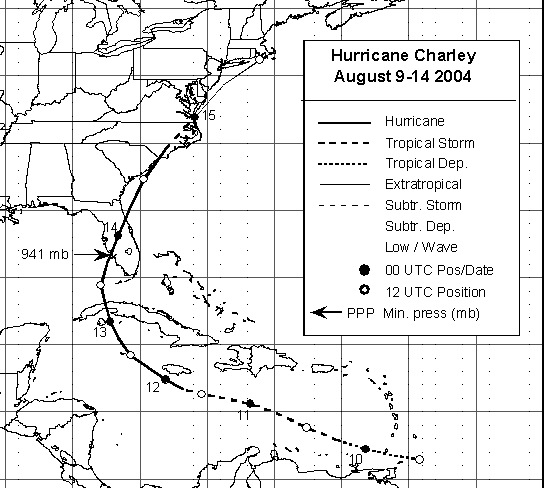
Below is a track of the cyclone provided by the National Hurricane Center.
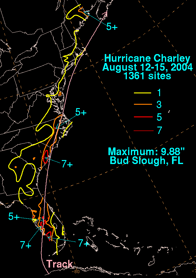
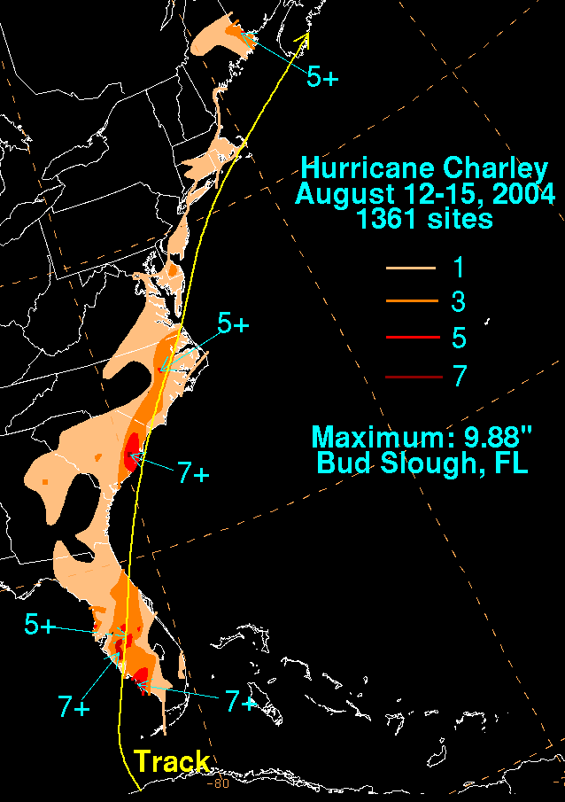
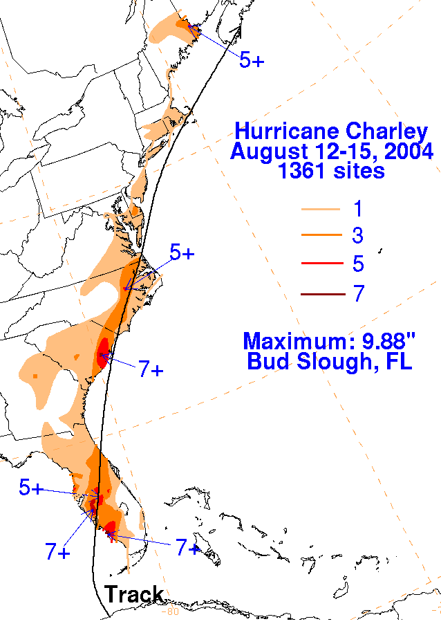
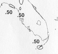
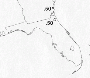
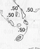
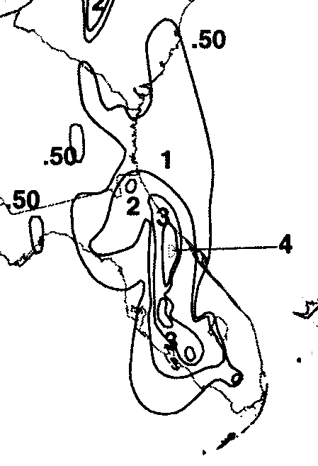
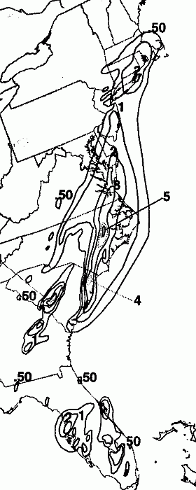
The storm total rainfall map below was constructed using data
from
data
provided from NWS
River Forecast Centers, as well as additional reports
received by the
National Hurricane Center.
 |
 |
 |
Below are the calendar for Daily Precipitation Maps. Note that the 24-hour periods end
at 12z that morning.