A tropical wave emerged off of western Africa on July 25th and 26th. The wave moved quickly westward across the eastern and central tropical Atlantic during the next several days, but shower activity was limited due to its movement through a subsident environment. The wave crossed 50°W on the 30th, and showers and thunderstorms began increasing ahead of the wave axis before it moved over the Lesser Antilles on the 31st. Shower and thunderstorm activity continued to increase but remained disorganized on August 1st while the wave moved west-northwestward across Puerto Rico and Hispaniola. Showers and thunderstorms showed increased signs of organization on the 2nd while the wave moved across eastern Cuba and late that day, surface observations and radar data indicated the system had acquired a well-defined circulation. A tropical depression formed on the evening of the 2nd, about 65 miles west-southwest of Camaguey, Cuba. The depression moved west-northwestward across western Cuba on the morning of the 3rd and then emerged over the southeastern Gulf of Mexico, where it strengthened into a tropical storm early that afternoon.
The storm gradually turned northwestward and northward on the 4th while moving around the western periphery of a subtropical ridge over the western Atlantic. Debby rapidly intensified on the 4th to the west of Florida within an environment of weak vertical wind shear over extremely warm sea-surface temperatures. Debby developed an inner core a ragged mid-level eye late on the 4th. Debby became a hurricane by the evening of the 4th when it was centered about 90 miles west-northwest of Tampa, Florida. The hurricane continued northward, then gradually turned north-northeastward overnight ahead of a deep-layer trough over the eastern United States while maintaining its strength. Debby made landfall as a hurricane just west of Steinhatchee, Florida, early on the morning of the 5th. Debby quickly regained tropical storm status after landfall, moving northeastward over the Florida Panhandle and crossing into southeastern Georgia that night. The center of the storm moved slowly northeastward on the 6th and passed near Savannah, Georgia, early in the afternoon, then turned eastward and moved offshore the coasts of Georgia and South Carolina that evening.
During this time, Debby began to exhibit hybrid cyclone characteristics. The central convection of the storm collapsed due to significant intrusions of dry air resulting from the upper-level trough interaction. Debby also had a large radius of maximum winds (RMW) and an asymmetric wind field after emerging over the southwestern Atlantic. Therefore, Debby is best classified as a subtropical storm beginning on the evening of the 6th, when it was located about 30 miles east of Savannah. Debby meandered offshore within weak steering currents on the 7th. During the late morning, weakening commenced as Debby was unable to regenerate organized convection closer to its center. The system’s circulation became increasingly elongated as it approached the coast, but Debby made landfall as a subtropical storm around Bulls Bay, South Carolina during the night of the 7th. After landfall, Debby moved across eastern South Carolina and into central North Carolina, where the system merged with a front and became extratropical on the evening of the 8th. The low accelerated northeastward across the Mid-Atlantic and Northeast United States that day, then moved across portions of southern Quebec and over the Gulf of St. Lawrence on the 10th. That evening, the extratropical low became absorbed by a new area of low pressure over the northern Atlantic.
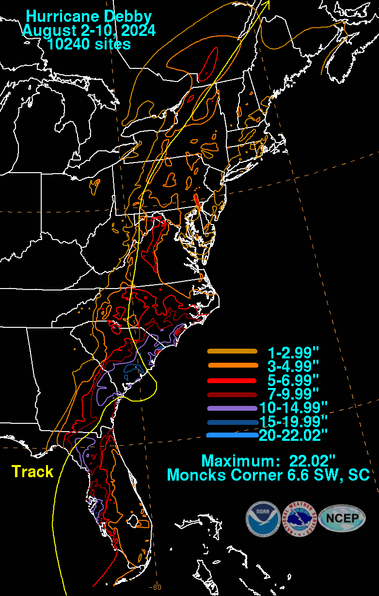
The graphics below show the storm total rainfall for Debby, which used rain gage information from National Weather Service River Forecast Centers, xMACIS2, National Weather Service Forecast Offices, and CoCoRAHS.
 |
 |
 |