The origin of Isaias can be traced back to a vigorous tropical wave that moved offshore western Africa on
July 24th. The wave moved westward, steered by a large subtropical ridge to its north. A broad area of
low pressure developed with the wave on the 25th, but convection remained disorganized and confined mainly to
its southern portion through early on the 26th due to dry air entrainment. Later that day, thunderstorm activity
briefly became better organized while the disturbance was located about midway between Africa and the Lesser
Antilles, but quickly waned. The convection became better organized late on the 27th; however, the system’s
low-level circulation remained broad and elongated. By the evening of the 28th, the system produced tropical-
storm-force winds over a large area within the northern portion of the circulation as it approached the Lesser
Antilles but it still lacked a well-defined center. The disturbance crossed the Lesser Antilles that day, bringing
widespread heavy rainfall and strong winds to the central and northern portions of those islands, with these
conditions spreading across the Virgin Islands and Puerto Rico by late in the day. Scatterometer passes indicated
that the system had developed a sufficiently well-defined center and it is estimated to have become a tropical storm
late on the 29th when it was located south of Ponce, Puerto Rico.
Isaias turned west-northwest and then northwest as it reached the southwest portion of the ridge. During the next day
or so, Isaias exhibited a large area of tropical-storm-force winds and a band of deep convection over the northern
portion of the circulation, which spread across Puerto Rico and eastern portions of the Dominican Republic. Its first
landfall occurred midday on the 30th near San Pedro De Macoris in the southeastern Dominican Republic, and the cyclone’s
center crossed the eastern portion of the country. Despite land interaction, Isaias strengthened as a mid-level center emerged
near the northern coast of Hispaniola, and surface observations indicated that the low-level center began to redevelop under that
feature later that day. By the evening of the 30th, about the same time that the bulk of Isaias’ circulation emerged over the
Atlantic, data from reconnaissanc eaircraft indicated that the cyclone had strengthened into a hurricane while the center was
located just offshore of the northern coast of Hispaniola. Isaias continued to move northwestward and made its second landfall
early on the 31st as the center crossed Great Inagua Island in the southeastern Bahamas and then passed just west of the central
Bahamas through early on August 1st. During that time, the wind field gradually contracted, and a central dense overcast (CDO)
feature temporarily developed with an embedded small eye as noted in radar imagery from the Bahamas. Both the satellite and radar
appearance of the cyclone began to degrade early on the 1st due to an increase in westerly shear and dry air entrainment, and weakening
began. Isaias made its third landfall on Andros Island at 1300 UTC 1 August and weakened to a tropical storm by early afternoon as it
emerged back over the waters west of the island. Early on the 2nd, the tropical storm made its closest approach to southeast Florida,
with the center coming within 40 miles of West Palm Beach and Fort Lauderdale. The cyclone turned toward the north-northwest into a
weakness of the Bermuda-Azores ridge that had developed from northern Florida to offshore of Georgia. This path kept the center of
Isaias offshore of the east coast of Florida and over the warm waters of the Gulf Stream, which helped to maintain the storm’s
intensity while it continued to be affected by strong westerly shear.
On the 3rd, Isaias turned toward the north, and then north-northeast with an increase in forward speed as the cyclone moved through
the weakness in the ridge into southwesterly flow ahead of an approaching mid- to upper-level trough over the United States. Later
that day, the shear magnitude decreased while the cyclone’s motion became parallel to the upper level flow, which allowed Isaias to regain
organization and strengthen into a hurricane in the early afternoon while located about 100 miles south of Charleston, South Carolina. Isaias
continued to quickly strengthen, reaching its peak intensity on the evening of the 3rd when located just off the coast of South Carolina. The
hurricane made its fourth and final landfall near Ocean Isle Beach, North Carolina, on the night of the 3rd as a hurricane. Isaias then
weakened to a tropical storm by 0600 UTC that morning while located southwest of Greenville, North Carolina. The cyclone continued
to accelerate north-northeastward after landfall, with the center moving across Virginia, Maryland, Delaware, Pennsylvania, New
Jersey, New York, and Vermont on the 4th. Isaias did not weaken as rapidly as a tropical cyclone moving over land due to the influence of
a mid- to upper-level trough and a significant portion of Isaias’ circulation remaining over water. This resulted in the storm maintaining
an intensity of 55–60 kt as its center moved parallel to but about 100 miles inland of the U.S. east coast. During this time, Isaias
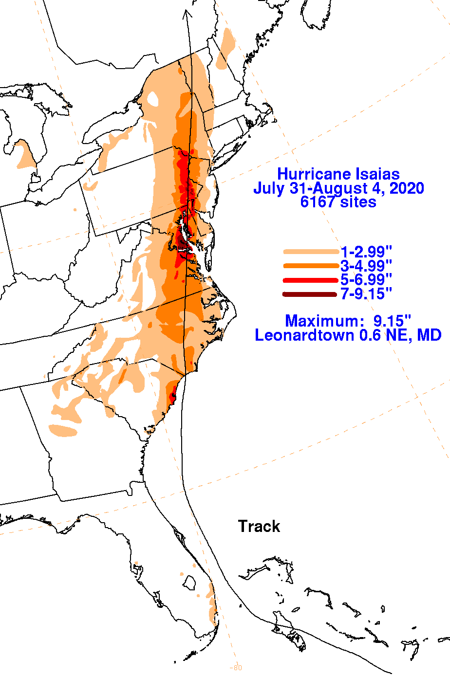
produced a swath of heavy rainfall, strong damaging winds, and tornadoes from South Carolina through the Mid-Atlantic states and New
England. By the evening of the 4th, surface and radar observations indicated that Isaias had lost tropical character and became
an extratropical low as it crossed from Vermont into southeastern Canada.
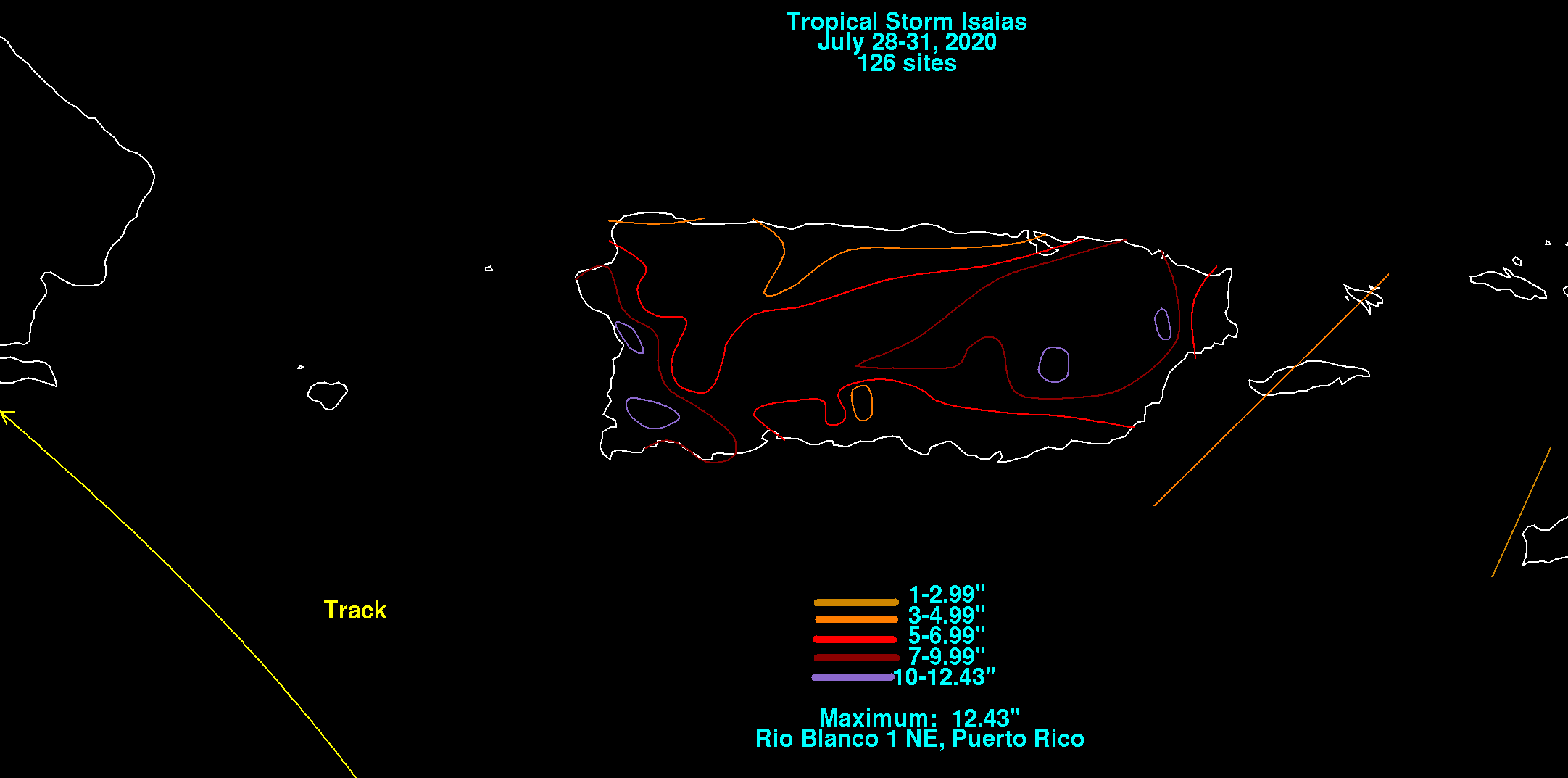
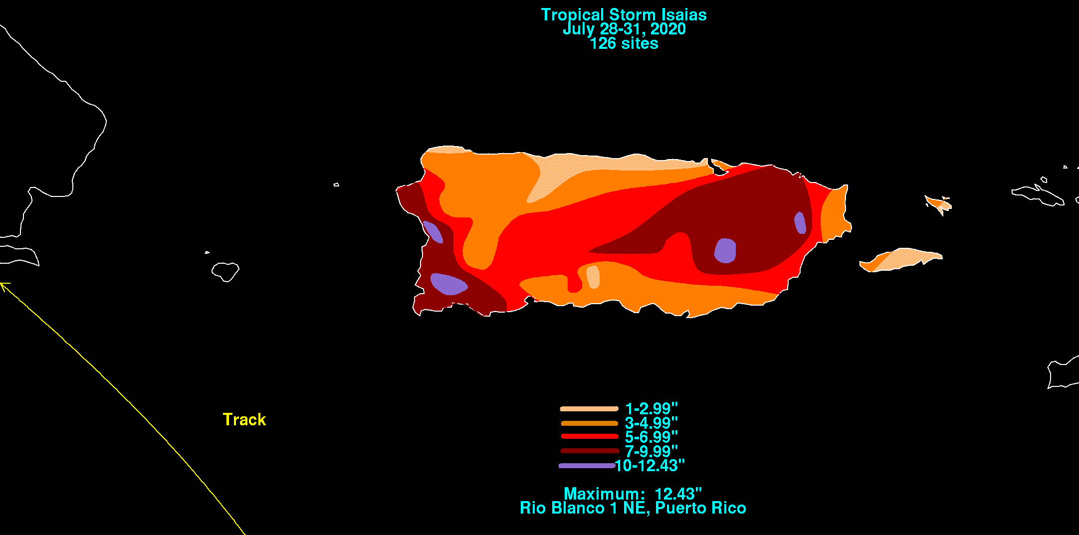
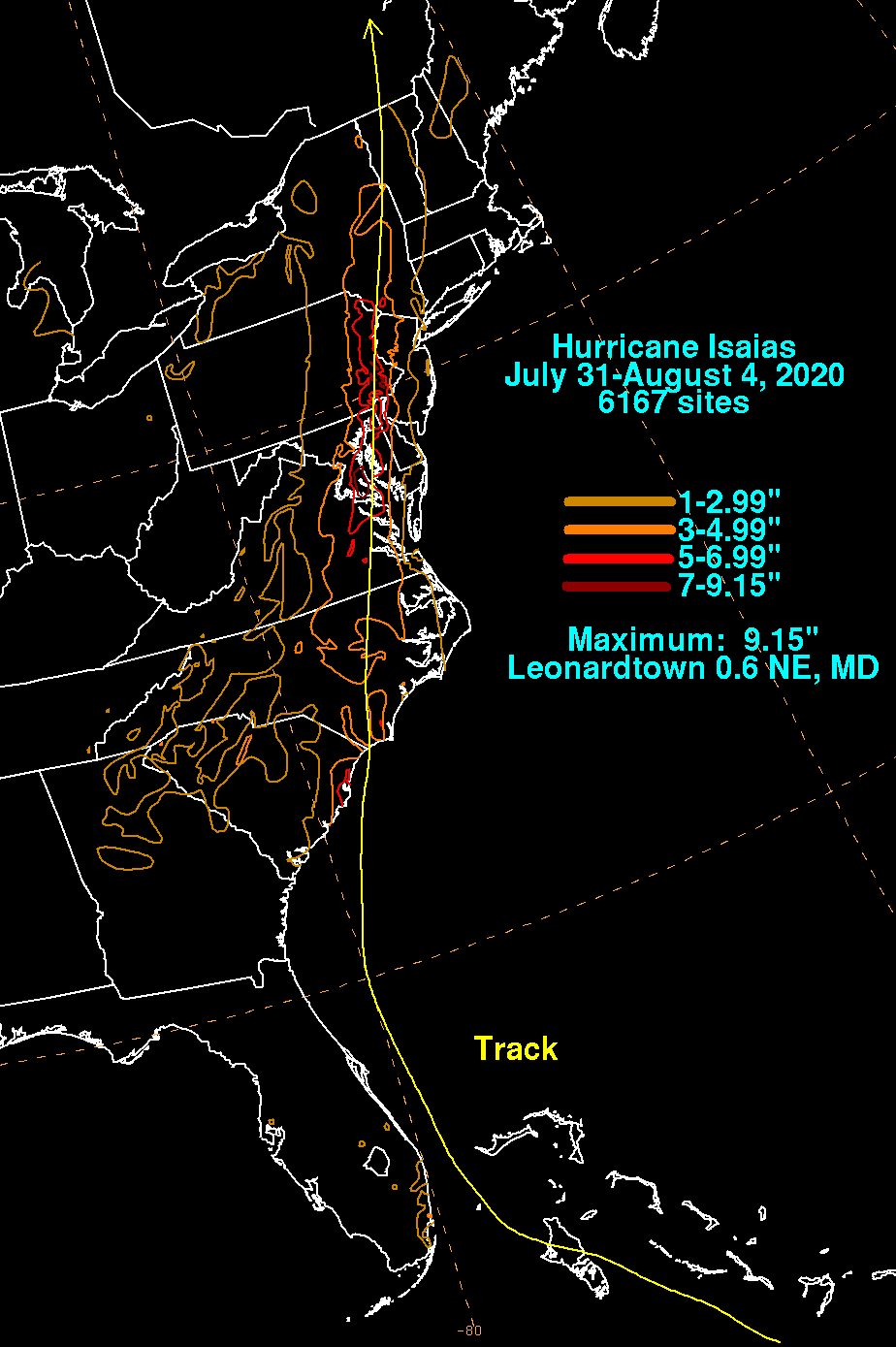
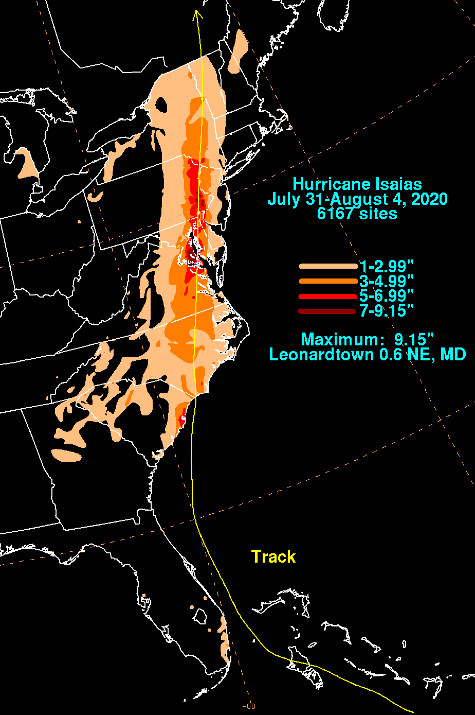
The graphics below show the storm total rainfall for Isaias, which used rain gage information from the National Weather
Service River Forecast Centers, Forecast Offices, and CoCoRAHS.
 |
 |
 |
 |
 |
 |