Kyle formed from a non-tropical low pressure system in the
central
North Atlantic Ocean. A cold front moved across
Bermuda on 13 September and stalled to the southeast of the island
by 15 September. The stationary front gradually
weakened and became an elongated area of low pressure by 18 September.
A sharp mid-level shortwave trough
moved off the southeast coast of the United States and likely acted
as the triggering mechanism for the development
of a stationary low pressure center by the morning of the 19th about
750 n mi east-southeast of Bermuda. Thunderstorms
gradually developed into narrow bands a few hundred miles away from
the well-defined low-level circulation center.
Surface winds gradually increased to 25 kt early on 20 September and
the overall satellite cloud pattern became much
better organized. By early afternoon, it is estimated that Subtropical
Depression Twelve had developed about 715 n mi
east-southeast of Bermuda.
Later that day, the system made a clockwise loop as it became
embedded
in weak steering between its parent upper-
level low to the south and a mid-latitude trough to the north.
Based on satellite estimates, the cyclone intensified into
Subtropical Storm Kyle on the night of the 20th when it was about 680
n mi east of Bermuda. While making the loop,
thunderstorms developed around the low-level center and Kyle gradually
acquired warm-core, tropical characteristics.
It is estimated that Kyle became a tropical storm just after noon on
the 22nd about 760 n mi east of Bermuda. Still
under the influence of weak steering currents, Tropical Storm Kyle
drifted erratically toward the southwest for about a
week and steadily intensified. Kyle became a hurricane on the morning
of the 25th while 550 n mi east-southeast of
Bermuda. The storm peaked, with maximum sustained winds of 85
mphm, during the morning of the 26th about 425
n mi east-southeast of Bermuda. Kyle maintained this intensity for
the next 24 hours before gradually weakening under
the influence of moderate northwesterly to northerly vertical shear.
After Kyle weakened below tropical storm strength after noon on the
30th, the cyclone made a slow counter-clockwise
loop about 300 n mi west of Bermuda from 5-8 October. Afterwards, Kyle
moved westward and then northwestward
before making landfall along the South Carolina coast late on the 11th.
During this period, fluctuations in intensity
occurred and Kyle strengthened back into a tropical storm on 1, 6,
and 11 October.
After making its first landfall near McClellanville, South Carolina
just at noon on the 11th, Tropical Storm Kyle moved
northeastward and skirted the remaining upper coastline of South
Carolina.
Its center moved inland again a few hours
later near Long Beach, North Carolina around 5 pm EST. Kyle weakened
to a tropical depression by the evening of the
11th near Surf City, North Carolina and then strengthened back into
a tropical storm over Pamlico Sound six hours later.
Shortly thereafter, it exited the eastern portion of the state near
Nags Head around 3 am EST. The cyclone eventually
merged with a cold front later that morning, when it was located about
280 n mi south-southwest of Nantucket,
Massachusetts. Kyle lasted for 22 days, making it the third
longest-lived
Atlantic tropical cyclone, after Ginger of
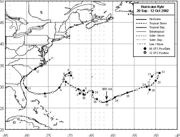
1971 and Inga of 1969. Below is the track of Kyle, provided by
the National Hurricane Center.
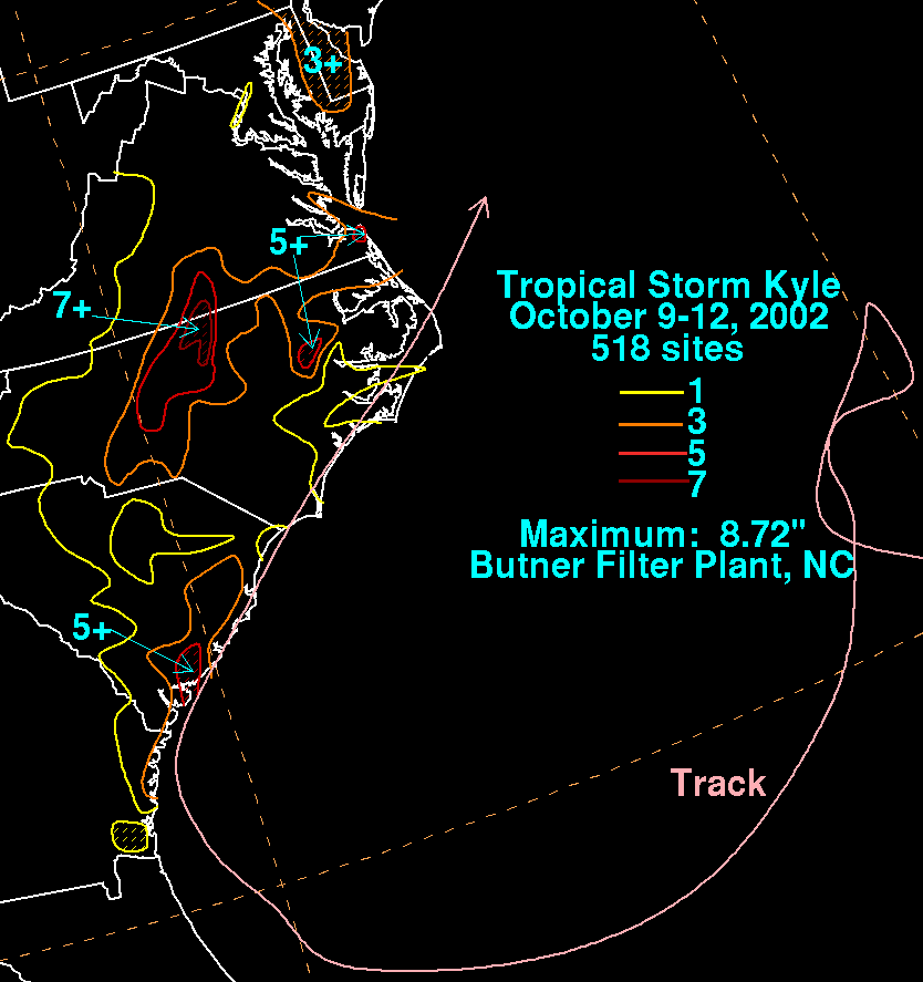
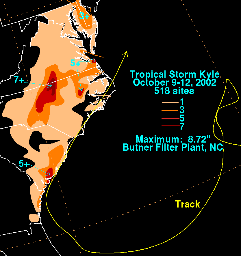
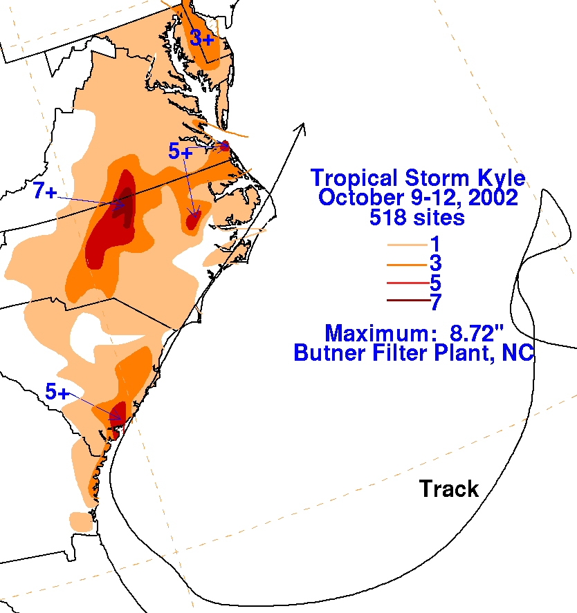
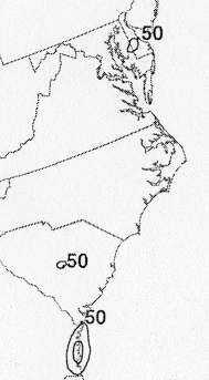
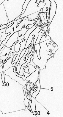
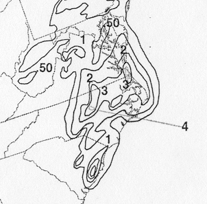
The storm total rainfall map below was constructed using data
provided
by the National Climatic Data Center.
 |
 |
 |
Below are the calendar for Daily Precipitation Maps. Note that the 24-hour periods end at 12z, or 8 am EDT, that morning.