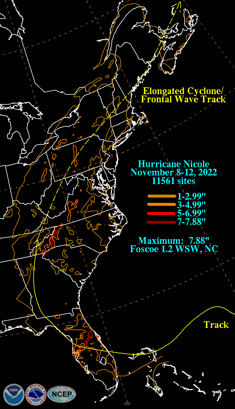
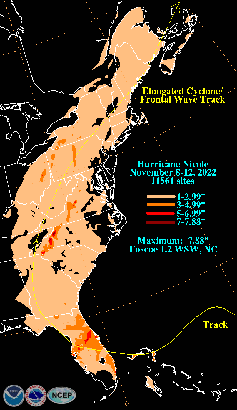
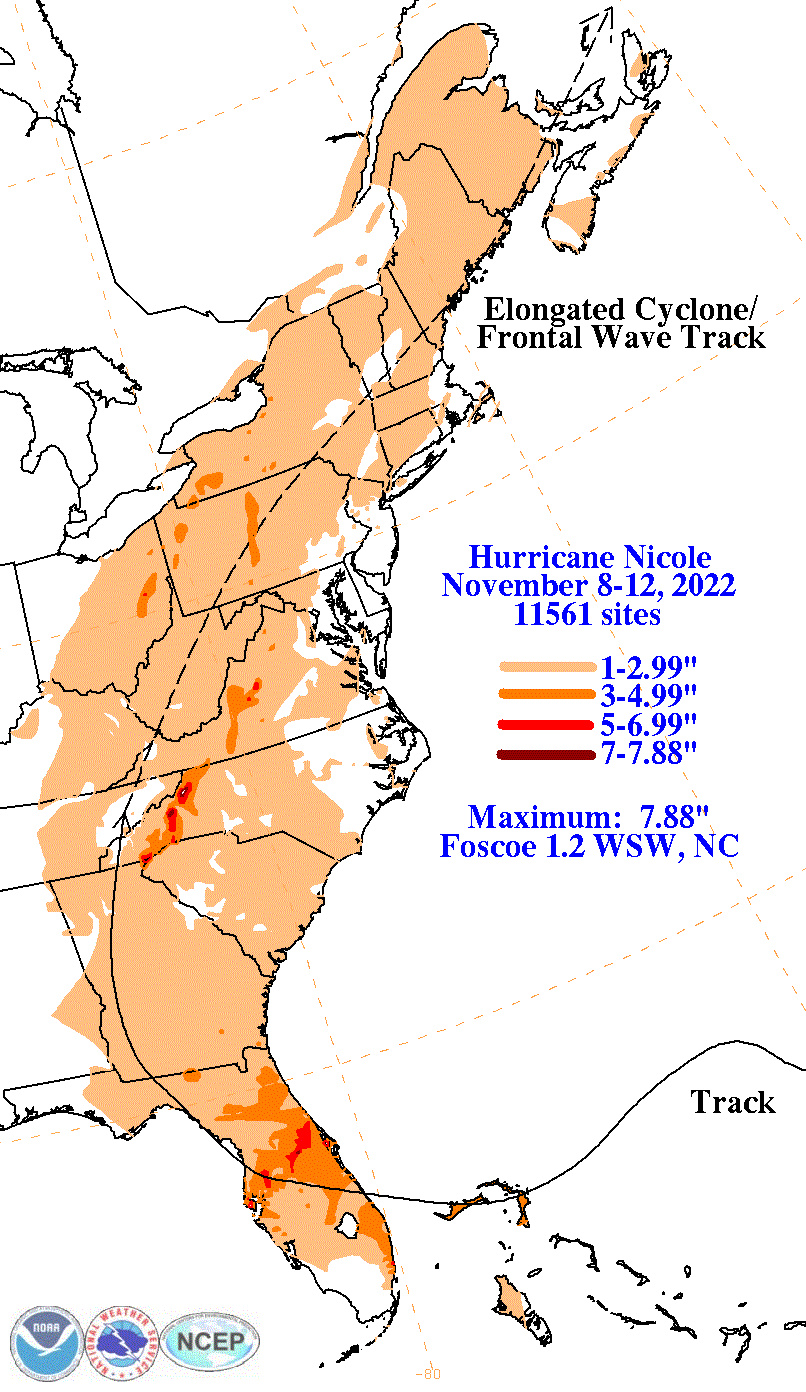
A mid- to upper-level trough in the Westerlies moved from the U. S. Mid-Atlantic states into the western Atlantic on November 3rd. This feature moved generally southward over the western Atlantic for the next two days, and during this time it gradually cut off from the westerlies to become a closed low. Upper-level divergence in the southeastern quadrant of this system interacted with the Intertropical Convergence Zone over northern South America on the 4th, and this combination caused a large area of convection over much of the eastern Caribbean Sea and the adjacent Atlantic north of the Virgin Islands and Puerto Rico. A broad low-pressure area formed over the Caribbean Sea south of Hispaniola on the 5th. This low propagated north of Puerto Rico and became better defined on the 6th, and the associated winds increased to gale/tropical storm force later that day as the system coupled with the upper-level low. A subsequent increase in convective organization led to the formation of a subtropical storm on the night of the 6th about 470 miles south-southwest of Bermuda. . Nicole moved erratically northwestward on the 7th as the low-level center coupled with the upper-level low, and as the merged system was steered by southeasterly flow on the west side of a low- to mid-level ridge. On the 8th, a cold front with a low- to mid-level anticyclone to the front's north moved into the western Atlantic poleward of Nicole, which caused the cyclone to turn westward and then west-southwestward. Nicole intensified as convection became more concentrated near the center, and the system transitioned to a tropical storm that afternoon about 505 miles east-northeast of Nassau in the Bahamas. The interaction of the cyclone's circulation with the anticyclone caused the area of tropical-storm-force winds to grow in the northern semicircle, and by the 10th those winds extended over 400 miles from the center in the northeastern quadrant. The storm continued moving west-southwestward through the early part of the 9th. During the next several hours, though, mid- to upper-level dry air entrained into the core. This disrupted the central convection and caused a temporary weakening. The convection re-developed thereafter as Nicole turned westward, and the cyclone was again intensifying as a strong tropical storm when the center made landfall at Marsh Harbor on Great Abaco Island in the northwestern Bahamas around midday. That evening, Nicole reached hurricane strength as the center made landfall on Grand Bahama Island. The hurricane approached the western periphery of the low- to mid-level anticyclone, and it turned west-northwestward when it reached Grand Bahama Island. This motion brought the center across the northern end of the Straits of Florida and to landfall on the Florida coast at Vero Beach early on the 10th. No additional strengthening occurred as the center crossed the Gulf Stream due to disruption of the core convection by another intrusion of dry air, and the landfall intensity is estimated to be 65 kt with sustained hurricane-force winds limited to the waters off the east coast of Florida within what was an increasingly shallow swirl of low clouds associated with the storm. After the Vero Beach landfall, Nicole weakened to a tropical storm with limited thunderstorm activity as it moved northwestward across the Florida Peninsula, with the center passing between Orlando and Tampa before reaching the Gulf coast near Homosassa early on the afternoon of the 10th, setting November low pressure records along its unusual November path across Florida. The center spent only a short time over the water before it made another landfall at Cedar Key, Florida. After that, Nicole continued northwestward with the center near or just offshore of the coast of the Florida Big Bend. A final landfall occurred on the Florida coast on the evening of the 10th at the mouth of the Aucilla River. The center then passed near Tallahassee before moving into southwestern Georgia, where it weakened to a tropical depression, with continued minimal thunderstorm activity. Early on the 11th, Nicole turned northward over western Georgia between the Atlantic high and a mid-latitude trough and cold front approaching from the west. This was followed by a northeastward motion that brought the system across extreme western North Carolina into eastern Tennessee, through West Virginia and Pennsylvania, southern New York, southern New England, and appears to have been absorbed by a low pressure center that formed to its northeast across Atlantic Canada on the afternoon of the 12th. .
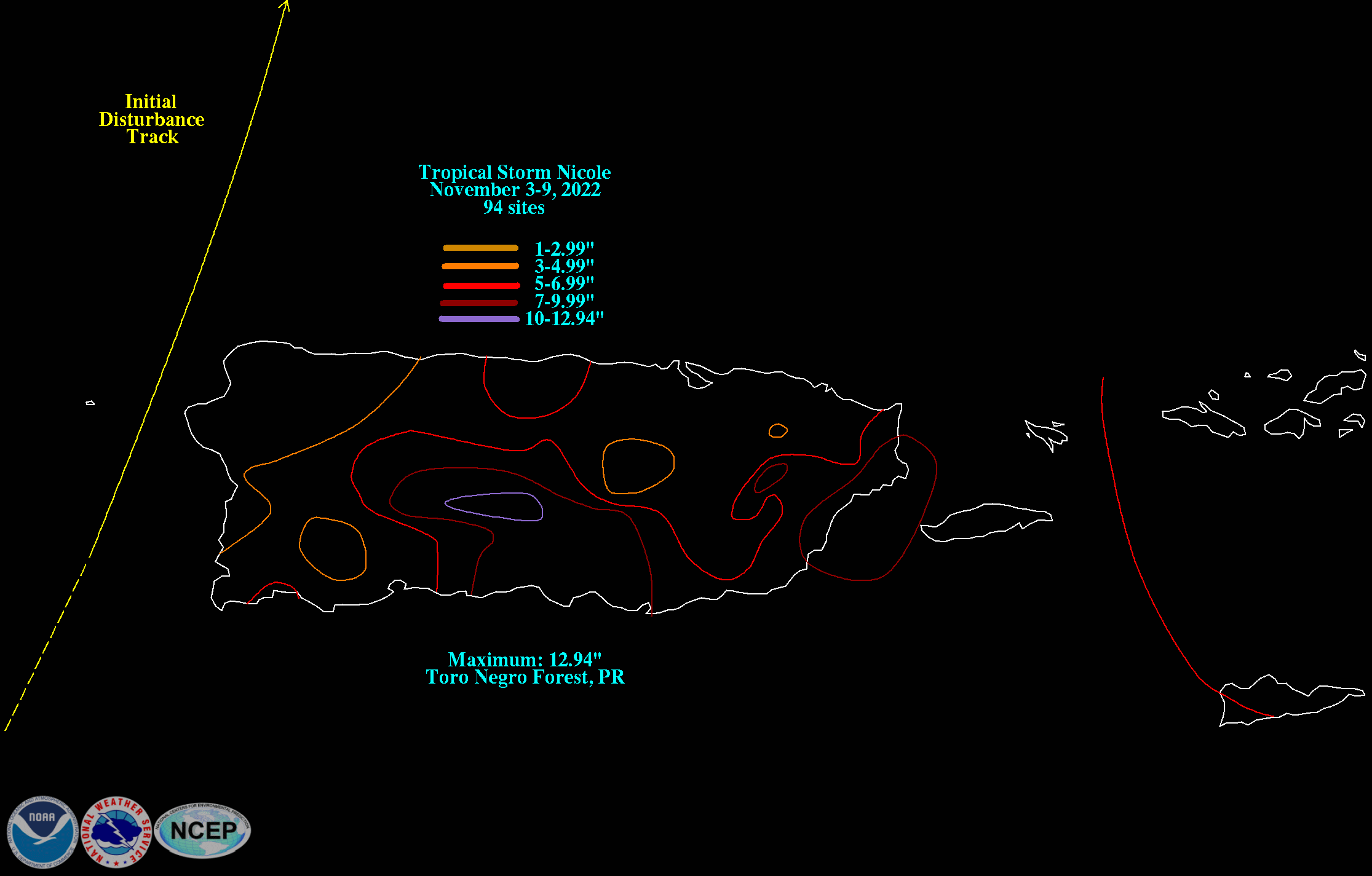
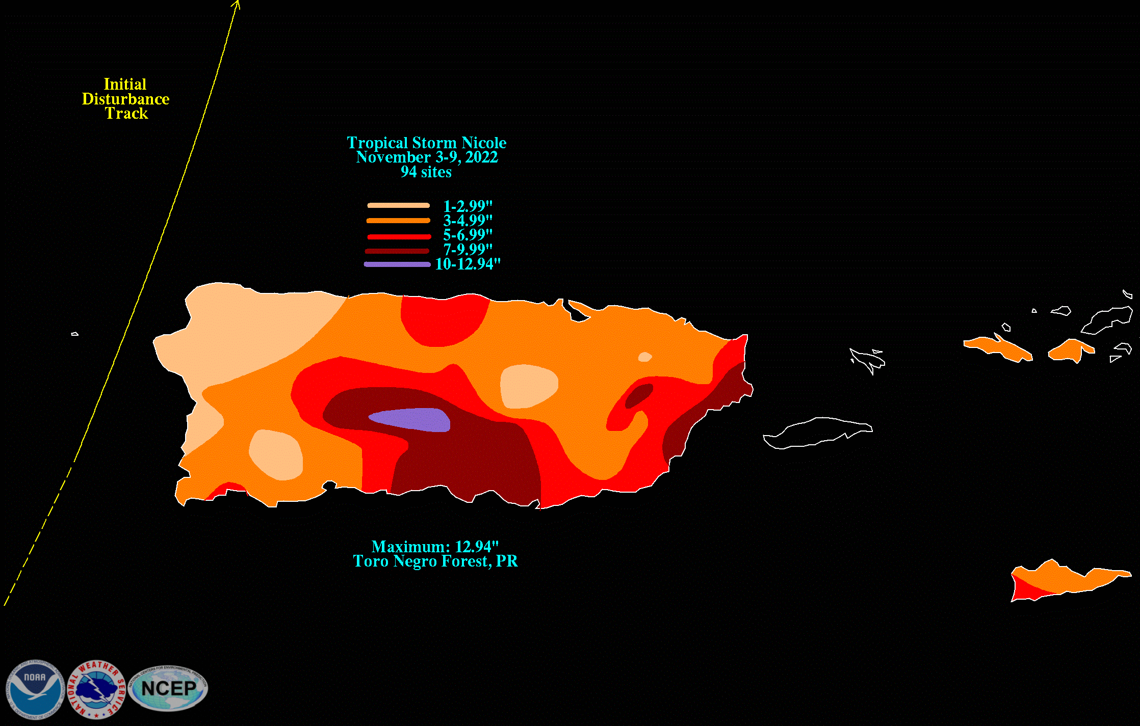
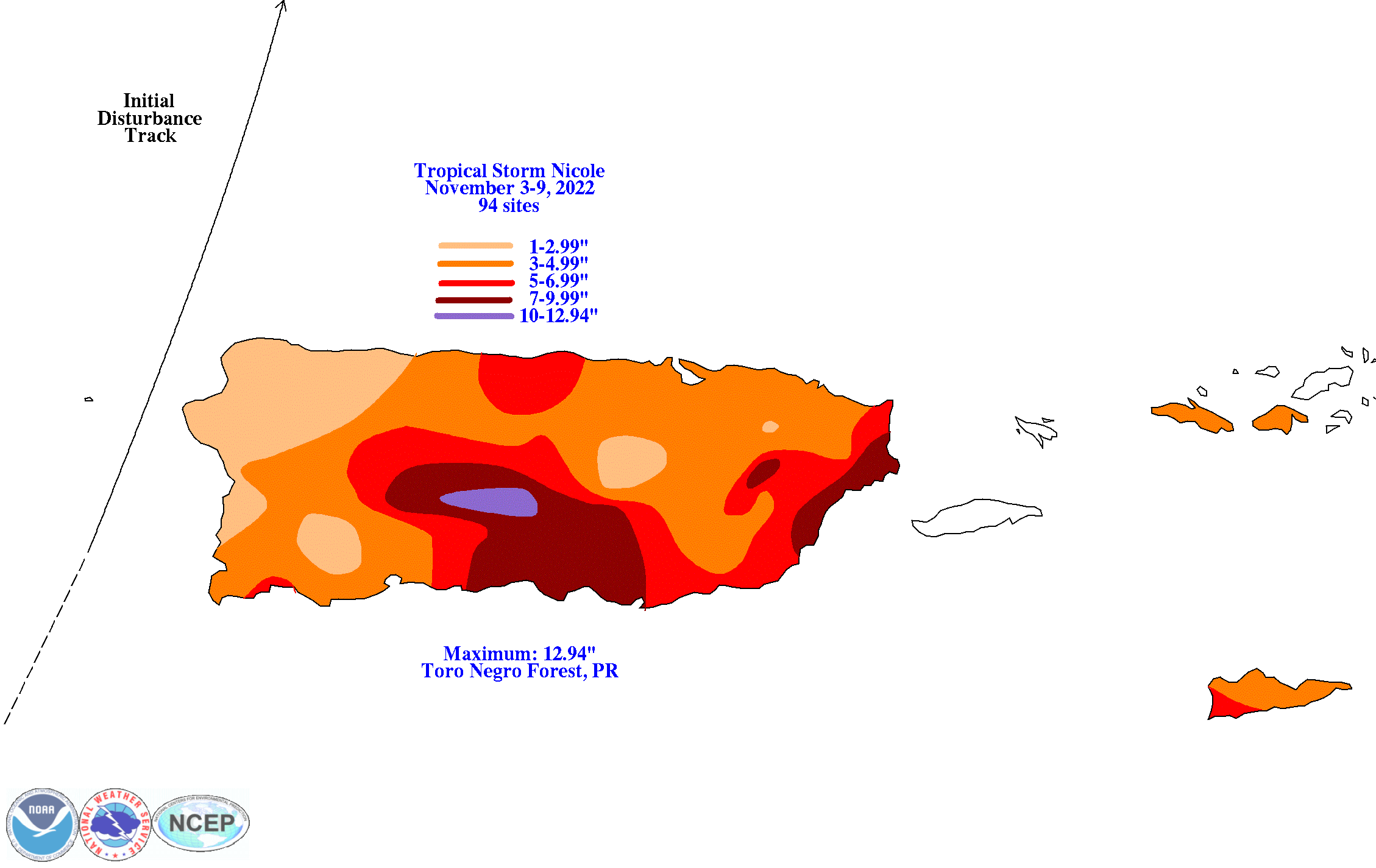
The graphics below show the storm total rainfall for Nicole, which used rain gage information from National Weather Service River Forecast Centers, National Weather Service Forecast Offices, and CoCoRAHS.
 |
 |
 |
 |
 |
 |