Excessive Rainfall Discussion
NWS Weather Prediction Center College Park MD
858 PM EDT Sat Jul 19 2025
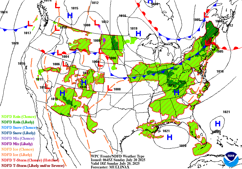
Day 1
Valid 01Z Sun Jul 20 2025 - 12Z Sun Jul 20 2025
...THERE IS A SLIGHT RISK OF EXCESSIVE RAINFALL OVER PORTIONS OF
THE MID-ATLANTIC AND CENTRAL PLAINS TO MS VALLEY...
...Mid-Atlantic...
One round of heavier convection is moving across eastern VA and
portions of northern NC this evening. Heavy rainfall rates have
been resulting in isolated to scattered instances of flash flooding
with this activity. Another area of more isolated convection is
moving across portions of WV and southwest VA. These cells are
smaller and less organized, but still producing localized heavy
rates and possible flash flooding. The former area of convection
should continue to push offshore and gradually weaken, and so the
flash flood risk from this activity should be on a downward trend.
The convection over WV and VA should also generally follow a
weakening trend this evening into tonight, although this activity
does have some shortwave forcing and stronger moisture transport
associated with it. Thus as it moves eastward tonight and interacts
with some lingering areas of instability, some small scale
convective clusters could persist from WV into VA. Not expecting
anything too organized...but even any small clusters will be
capable of producing heavy rates. Thus an isolated flash flood risk
could persist.
...Central and Northern Plains...
Convection this evening will pose an isolated to scattered flash
flood risk across portions of northern KS into south central NE.
Strong to severe convection has developed over this area near a
stationary front. The environment favors supercells and some
upscale growth of storms. Supercell motions are off to the
southeast, with the deep layer mean wind supporting cell motions
off to the northeast. This supports some cell merging as convection
continues to increase in coverage this evening...and with PWs
increasing towards 2", heavy rainfall rates are likely.
As we head into the overnight hours convection should expand in
coverage from eastern NE into IA near the stationary front. Expect
a broad are of convection to move west to east across IA near this
front bringing a heavy rainfall and flash flood risk. Both the 18z
HREF and 12z REFS have 3" neighborhood probabilities of 40-60%,
and recent runs of the HRRR and RRFS depict narrow swath(s) of
3-5" of rain through the overnight hours. The probability of
exceeding 5" of rain in the HREF/REFS drops off significantly, as
the quick eastward progression of convection should cap the upper
bound of rainfall totals. This axis from far eastern NE into
central IA is considered to be a higher end Slight risk...with
scattered flash flooding likely. This is especially true over
portions of central and eastern IA where soil moisture and
streamflows are already elevated. While the general quick movement
of the convection will hopefully prevent more widespread higher end
impacts...some training near the front will likely result in
scattered flash flood concerns, and locally significant impacts are
possible given the expected rainfall rates and training potential
near the front.
Chenard
Day 1 threat area:
www.wpc.ncep.noaa.gov/qpf/94epoints.txt
Excessive Rainfall Discussion
NWS Weather Prediction Center College Park MD
338 AM EDT Sun Jul 20 2025
Day 1
Valid 12Z Sun Jul 20 2025 - 12Z Mon Jul 21 2025
...THERE IS A MODERATE RISK OF EXCESSIVE RAINFALL IN AND NEAR
CENTRAL ILLINOIS...
...Midwest, Ohio Valley, & Southern Appalachians...
High moisture persists into Sunday -- precipitable water values
eclipsing 2.25" -- with the core of the instability pool more
significant across portions of the Ohio Valley on Sunday as warming
at 700 hPa occurs across the Central Plains, slowly strengthening
a mid-level capping inversion. Effective bulk shear remains
sufficient for convective organization, including mesocyclone
formation. Two rounds of convection are expected -- a morning round
dropping out of IA into the Midwest and Ohio Valley with a second
round forming in the vicinity of northeast KS during the afternoon
and evening hours. Of some concern is the backing of the low-level
winds during the 18-00z time frame, which could act to anchor any
existing convection in place/limit forward propagation. Any complex
that forms in northeast KS and northern MO is expected to spill
into portions of IL during the evening and overnight hours late
this day (into early Monday morning). Considering the degree of
moisture, instability, and effective bulk shear, there is the
potential for 3-4" amounts in an hour and local 8" totals. The
guidance has increased its signal for higher amounts with a few
pieces of guidance advertising 8-11" of rain in the 00z model suite,
so in coordination with LSX/St Louis MO, ILX/Central IL, and
IND/Indianapolis IN forecast offices, added a Moderate Risk area
in and near central IL. Localized High Risk impacts cannot be
ruled out should any training bands or cell backbuilding persists
for 3+ hours.
To the southeast of the Moderate Risk area, a higher end Slight
Risk appears to exist for much of the rest of the Ohio Valley and
western slopes of the Southern Appalachians, with some guidance
showing a secondary maximum between eastern KY and the KY/OH/WV
border junction. Lingering model uncertainty kept us from upgrading
to a Moderate Risk for the possible secondary maximum. With the
same rainfall potential -- hourly amounts to 3-4" with local 8"
totals possible -- localized Moderate Risk impacts cannot be ruled
out.
...Northern Plains...
The Dakotas/MN will be at the nose of a modest low level jet. A
shortwave moving by the area may be all it takes to initiate a
line of storms across the region, though there may be two separate
rounds: one in the morning and a second Sunday night. The guidance
has been slowly shifting east and southeast with time, and the
area of potential Slight Risk continues to shrink. Believe this is
a lower end Slight Risk.
Southwest/Southern Rockies...
Enough moisture is available for scattered monsoon convection on
Sunday, with the most noted across south-central AZ. Hourly
amounts to 2" are possible due to diurnal heating, which would be
most problematic in urban areas, dry washes/arroyos, or burn scars.
New England/Northern Mid-Atlantic states...
A cold front is expected to sweep through the region, which could
lead to locally heavy pockets of rainfall. Available moisture and
instability supports hourly rain amounts to 2" where cells can
manage to train or merge. Both the 00z HREF and 18z RRFS have a
heavy rain signal from 12z onward this morning from the eastern tip
of Long Island near Block Island, Martha's Vineyard, and Nantucket.
Recent radar imagery (as of this writing) shows a vorticity maximum
in this general neighborhood which could be the responsible party.
If so, it appears to be running ahead of the model guidance and
shouldn't be the threat advertised. Radar estimates are quite low
in its vicinity as is.
Roth
Day 1 threat area:
www.wpc.ncep.noaa.gov/qpf/94epoints.txt
Excessive Rainfall Discussion
NWS Weather Prediction Center College Park MD
338 AM EDT Sun Jul 20 2025
Day 2
Valid 12Z Mon Jul 21 2025 - 12Z Tue Jul 22 2025
...THERE IS A SLIGHT RISK OF EXCESSIVE RAINFALL FOR PORTIONS OF
KENTUCKY, TENNESSEE, SOUTHWEST WEST VIRGINIA, & WESTERNMOST
VIRGINIA...
In and near KY & TN...
An axis of moisture and instability pivots between a convective
frontal wave offshore the Southeast and a strengthening warm
advection pattern across the Plains. Declining low-level inflow
is noted with time, but the GFS forecasts enough effective bulk
shear for some level of convective organization during the period
of daytime heating, which doesn't drop off significantly until
around sunset. Consideration the degree of saturation area soils
have now and the expectation for further saturation on Sunday and
Sunday night, adding a Slight Risk area here makes sense. Hourly
amounts to 3" with local totals to 5" are possible where cells
train or merge which would be most problematic in urban areas and
over saturated soils. This appears more likely within the defined
Slight Risk than the surrounding Marginal Risk area. There was
some consideration for a Slight Risk for coastal sections of NC,
but with coastal marsh in some of those areas, decided against it.
Plains/Southern Rockies...
Surface boundaries/low pressure areas/upper level disturbances are
on this move this period, which along with warming temperatures at
700 hPa/increased mid- level capping across portions of the
Central Plains and IA should limit QPF and flash flood potential
elsewhere. Hourly amounts up to 2" and local totals to 4" are
considered possible in this region. At the moment, it appears any
flash flooding would be on an isolated to widely scattered basis.
In the Southwest and Southern Rockies, burn scars and dry
washes/arroyos would be most at risk. Anywhere within these
regions, urban areas would be of most concern.
Roth
Day 2 threat area:
www.wpc.ncep.noaa.gov/qpf/98epoints.txt
Excessive Rainfall Discussion
NWS Weather Prediction Center College Park MD
338 AM EDT Sun Jul 20 2025
Day 3
Valid 12Z Tue Jul 22 2025 - 12Z Wed Jul 23 2025
...THERE IS A SLIGHT RISK OF EXCESSIVE RAINFALL FOR PORTIONS OF
MINNESOTA, NORTHERN WISCONSIN, & NORTHWESTERN MICHIGAN...
In and near the Western Great Lakes...
A strengthening low-level jet out of the southwest is expected
downwind of an amplified Western trough and under the base of a
cold low moving across central Canada. Precipitable water values
rise to 2"+ and a broad reservoir of CAPE up to 5000 J/kg builds
near southeast SD due to significant warming at 700 hPa/a
strengthening mid-level capping inversion across portions of the
Plains to the east of the Western trough. Effective bulk shear
should be more than sufficient for organized thunderstorms,
including mesocyclone formation. Weekly rainfall anomalies show
that portions of the Arrowhead Peninsula and Upper Peninsula of
MI have had 300%+ of their average rainfall, leading to some degree
of saturation. Hourly rain amounts to 2.5" with local amounts to
5" could lead to flash flooding, with urban areas most prone to
issues. The Slight Risk was shifted somewhat north of continuity
per the latest guidance.
Southeast...
A potentially convective low retrogrades through portions of
northern FL this period. Precipitable water values rise to 2-2.25".
CAPE should rise to 3000 J/kg due to either daytime heating where
present or due to onshore flow from the warm western Atlantic,
Gulf, and FL Straits. There does appear to be enough effective bulk
shear present for at least some loose convective organization.
Hourly amounts to 3" and local totals to 6" are possible here.
Considered a Slight Risk as some portions of northern FL saw above
average precipitation with the previous retrograding convective low
on July 16-17, but the heavy rain signal at the moment shows
minimal overlap with the the previous convective low's rainfall
footprint.
Southern Rockies...
Enough moisture and instability is expected to hourly amounts up
to 2" and local totals to 4", with a distinct diurnal cycle
expected. At the moment, it appears any flash flooding would be on
an isolated to widely scattered basis. Burn scars and dry
washes/arroyos, and urban areas would be most at risk.
Roth
Day 3 threat area:
www.wpc.ncep.noaa.gov/qpf/99epoints.txt
Extended Forecast Discussion
NWS Weather Prediction Center College Park MD
237 AM EDT Sun Jul 20 2025
A cold front is progged to slowly drop southward across the Dakotas
and the Upper Midwest for the middle of the week, with a weak wave
of low pressure developing along it. This boundary will be
intersecting a warm and very humid airmass, and this is expected to
fuel the development of multiple thunderstorm complexes from
Nebraska to near Lake Superior Wednesday into Thursday. A Marginal
Risk area is valid for both Day 4 and Day 5 across much of this
region since some of the storms may have convective training, and
thus increasing the risk of localized flooding where this happens.
Improving conditions return to this region by Friday into next
weekend as a drier airmass settles in.
Another area of unsettled weather is expected to reside across
northern Florida and extending westward to the central Gulf Coast
mid to late week. A surface low is likely to form along a lingering
stationary front, and this should gradually track west through the
end of the week. There has been a modest increase in QPF associated
with this compared to the previous forecast issuance, but still
within the Marginal Risk category for Wednesday and Thursday with
the heaviest rainfall staying offshore during this time. The
rainfall potential continues into Friday as well, and this will
continue to be closely monitored in the days ahead. The potential
exists for several inches of rainfall in localized cases from
southern Louisiana to the Florida Panhandle, and a Slight Risk may
eventually be needed as the forecast guidance comes into better
focus in future model runs.
Elsewhere across the nation, moisture associated with the Southwest
U.S. monsoon will likely be reduced compared to recent days, with
some lingering showers/storms across New Mexico and into southern
Colorado, and affecting less of Arizona. However, there may be a
few convective cells that are slow moving across burnscar and other
sensitive areas, and therefore Marginal Risks remain prudent in the
excessive rainfall outlooks. Across New England, there will likely
be an axis of showers and thunderstorms moving in on Thursday, but
it currently does not look to cause much in the way of flooding
concerns.
The other big story will be the building heat across a large
portion of the east-central U.S. for the second half of the week
and into next weekend, courtesy of a large upper high becoming
anchored over the Mid-South. Heat Risk in the major category will
be prevalent from the Deep South to the Midwest and extending
eastward to include Tennessee and Ohio River Valleys to close out
the work week. Some of this heat will likely reach the East Coast
by Friday and next weekend following the pleasant stretch of
cooler weather for the first half of the week. Highs well into the
90s and even some low 100s will be commonplace from the Central
Plains to the East Coast, with the hottest readings across
Oklahoma, Texas, and Arkansas. It will also be uncomfortably warm
and humid at night, providing only limited relief from the heat.
Hamrick


