Excessive Rainfall Discussion
NWS Weather Prediction Center College Park MD
908 PM EDT Fri Jul 18 2025
Day 1
Valid 01Z Sat Jul 19 2025 - 12Z Sat Jul 19 2025
...THERE IS A SLIGHT RISK FOR EXCESSIVE RAINFALL FOR PORTIONS OF
THE MID-ATLANTIC, OHIO VALLEY, NORTHERN PLAINS AND SOUTHWEST...
...Mid-Atlantic...
A Slight risk remains for much of eastern VA into northeast NC.
Convection near a backdoor front will continue to pose some flash
flood risk into the evening hours. Cells are generally moving quick
enough to limit the magnitude and extent of impacts...however with
PWs around 2.3" rainfall rate potential remains very high. So even
some brief backbuilding and/or merging of cells will likely be
enough to get a quick 2-3" of rain. Thus scattered flash flooding
remains likely over the next few hours as convection continues to
move eastward, with the risk expected to decline as we get into the
overnight hours.
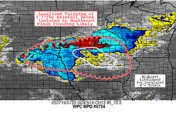
...OH Valley...
We will carry a small Slight risk across portions of KY and TN
where some training of cells has resulted in a more focused area
of scattered flash flood warnings this evening. One area of slower
cell movement near the stationary front over KY, and another over
northern TN where just enough low level southerly inflow is
resulting in some backbuilding of cells. Both areas are probably
peaking now or will shortly, with the risk gradually decreasing as
instability is eroded tonight.
....Plains to Upper Midwest...
A Slight risk remains across portions of southeast SD, northeast
NE, southern MN and much of central and northern IA. Convection is
expected to increase in coverage and magnitude through the evening
hours, with upscale growth into a couple clusters or MCS during the
overnight hours. Initially cell movement will be off to the east,
but as convection organizes it will likely take a turn off to the
southeast. As this is occurring we could see enough of a training
component to result in isolated to scattered flash flood concerns.
The same can be said on the southwest flank of the eventual MCS or
convective cluster, with backbuilding into the low level jet
supporting some flash flood potential. The overall cell motions
will be quick enough to keep flash flood coverage and magnitude
down...however recent runs of both the HRRR and RRFS indicate a
swath of over 3" of rain...much of which will likely fall in an
hour or two. This should be enough to result in isolated to
scattered instances of flash flooding...especially across any more
susceptible low lying or urban areas.
...Southwest...
Maintained a Slight risk across portions of far southeast AZ into
southern NM where convective coverage still supports an isolated
to scattered flash flood risk for a couple more hours. Otherwise a
Marginal risk remains for a broader portion of NM and portions of
NV and UT where convective coverage and intensity are generally on
a downward trend, however a localized flash flood persists.
Chenard
Day 1 threat area:
www.wpc.ncep.noaa.gov/qpf/94epoints.txt
Excessive Rainfall Discussion
NWS Weather Prediction Center College Park MD
350 AM EDT Sat Jul 19 2025
Day 1
Valid 12Z Sat Jul 19 2025 - 12Z Sun Jul 20 2025
...THERE IS A SLIGHT RISK OF EXCESSIVE RAINFALL FOR PORTIONS OF
THE MIDWEST, THE MID-SOUTH, THE SOUTHERN MID-ATLANTIC STATES, &
THE SOUTHERN APPALACHIANS...
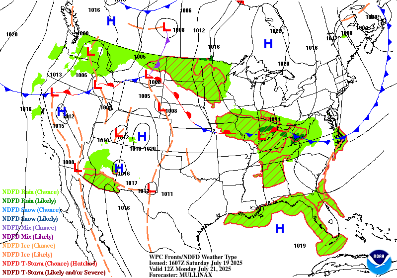
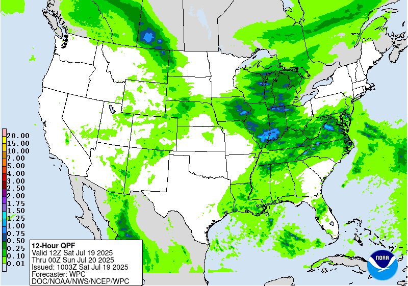
Corn Belt/Ohio Valley/Mid-Atlantic States/Mid-South...
Ample moisture exists regionally. Some of this is due to the
synoptic pattern, with the Westerlies stronger than and south of
July norms which is allowing for greater effective bulk shear and
thunderstorm organization. Some of the moisture influx is also due
to the flow around the retrograding 3 sigma warm core ridge for
mid- July moving into the eastern Gulf. Additional moisture is
being imported from the direction of the former tropical
disturbance. Regardless of the source, precipitable water values
are forecast to crest at or above 2.25". ML CAPE could exceed 4000
J/kg due to daytime heating. Portions of IA, IL, and KY have the
potential for backbuilding convection both Saturday morning and
Saturday night/Sunday morning. Across IA, there is a question about
how much overlap convection dropping in from the north this
morning would have with convection Saturday night/Sunday morning.
Within such an environment, hourly rain amounts to 4" are possible,
with local amounts to 8". At the moment, these amounts are not
explicitly forecast by much of the guidance, with the 00z HREF/18z
RRFS showing minimal potential for 5"+ amounts, centered across IA.
However, the high resolution NAM and Canadian Regional show local
totals in the 6" ballpark. Large swaths of the region have had
well above average rainfall during the past week, saturating soils.
Since there's a bit of uncertainty, coordination with DMX/Des
Moines IA and DVN/Davenport IA have left the risk area as a high-
end Slight. However, should cells train for 2+ hours downstream of
existing instability pools, localized Moderate or High Risk
impacts cannot be ruled out.
Southwest/Southern Rockies...
Enough moisture is available for scattered monsoon convection again
on Saturday. Hourly amounts to 2" are possible due to diurnal
heating, which would be most problematic in urban areas, dry
washes/arroyos, or burn scars.
Roth
Day 1 threat area:
www.wpc.ncep.noaa.gov/qpf/94epoints.txt
Excessive Rainfall Discussion
NWS Weather Prediction Center College Park MD
350 AM EDT Sat Jul 19 2025
Day 2
Valid 12Z Sun Jul 20 2025 - 12Z Mon Jul 21 2025
...THERE IS A SLIGHT RISK OF EXCESSIVE RAINFALL FOR PORTIONS OF THE
MIDWEST, SOUTHERN APPALACHIANS, & NORTHERN PLAINS...
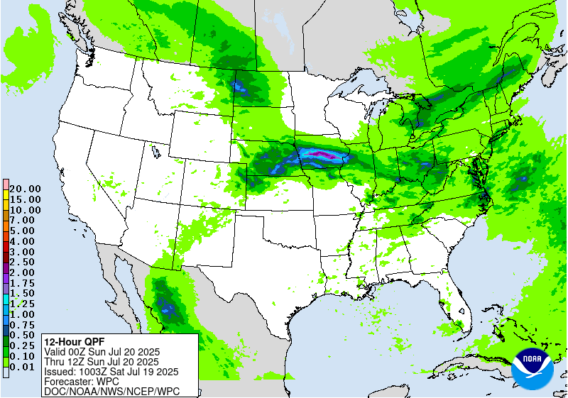
...Midwest, Ohio Valley, & Southern Appalachians...
High moisture for Saturday persists into Sunday -- precipitable
water values eclipsing 2.25" -- with the core of the instability
pool more significant across portions of the Ohio Valley on Sunday
as warming at 700 hPa occurs across the Central Plains, slowly
strengthening a mid-level capping inversion. Effective bulk shear
should remain sufficient for convective organization. Inflow off
the instability pool could lead to backbuilding, so the potential
for 4" amounts in an hour and local 8" totals remains (the 00z NAM
advertised 7"). There's not enough confidence on where the higher
amounts will materialize to upgrade to a Moderate Risk, but a
higher end Slight Risk appears to exist from in and near southern
IL into KY, TN, southern WV, and westernmost VA. Localized Moderate
or High Risk impacts cannot be ruled out.
...Northern Plains...
Much of North Dakota will be at the nose of a potent low level jet
across the area. A subtle shortwave in the upper level jet may be
all it takes to initiate a line of storms across the region,
though there may be two separate rounds: one in the morning and a
second Sunday night. There is considerable uncertainty both with
storm intensity and receptivity of the ground to the heavy
rainfall. Used the recent guidance to trim some of the Slight Risk
area away. Like continuity, believe this is a lower end Slight
Risk.
Southwest/Southern Rockies...
Enough moisture is available for scattered monsoon convection on
Sunday. Hourly amounts to 2" are possible due to diurnal heating,
which would be most problematic in urban areas, dry washes/arroyos,
or burn scars.
Roth/Wegman
Day 2 threat area:
www.wpc.ncep.noaa.gov/qpf/98epoints.txt
Excessive Rainfall Discussion
NWS Weather Prediction Center College Park MD
350 AM EDT Sat Jul 19 2025
Day 3
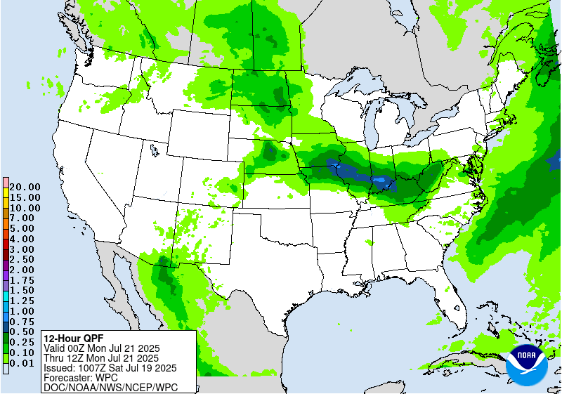
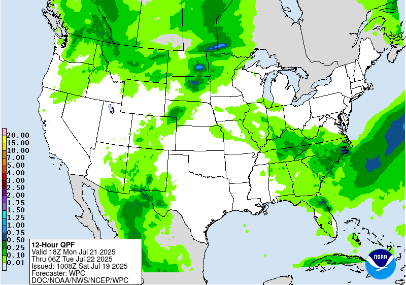
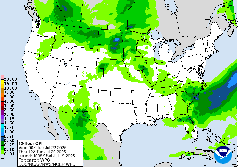
Valid 12Z Mon Jul 21 2025 - 12Z Tue Jul 22 2025
...THERE IS A MARGINAL RISK OF EXCESSIVE RAINFALL FOR PORTIONS OF
THE SOUTHERN ROCKIES, PLAINS, OHIO VALLEY, & SOUTHEAST...
Surface boundaries/low pressure areas/upper level disturbances are
on this move this period, which along with warming temperatures at
700 hPa/increased mid- level capping across portions of the
Central Plains and IA should broadly limit QPF and flash flood
potential. Wherever cells can manage to train/merge, hourly rain
amounts up to 3" with local totals to 6" would be possible across
the Plains, Ohio Valley, and Southeast, while hourly amounts up to
2" and local totals to 4" would be possible across the Southern
Rockies and Southwest. At the moment, it appears any flash flooding
would be on an isolated to widely scattered basis. In the
Southwest and Southern Rockies, burn scars and dry washes/arroyos
would be most at risk. Anywhere within these regions, urban areas
would be of most concern.
Roth
Day 3 threat area:
www.wpc.ncep.noaa.gov/qpf/99epoints.txt
Extended Forecast Discussion
NWS Weather Prediction Center College Park MD
253 AM EDT Sat Jul 19 2025
It remains the case that an axis of unsettled weather will remain
in place across the Upper Midwest and also the Southeast U.S. for
the beginning to middle of the week. Thunderstorm complexes
traveling around the northern periphery of the big upper high will
likely produce localized areas of heavy rainfall, potentially
exceeding an inch per hour or more. Therefore, a broad Marginal
Risk area extends from the eastern Dakotas to the western Great
Lakes on Tuesday where a cold front will be intersecting a warm and
humid airmass to the south. There is a good chance that a Slight
Risk could eventually be needed in later outlooks as confidence on
the main QPF axis becomes more certain. Across the Deep South and
northern Florida, a lingering stationary front will help focus deep
moisture with a potential wave of low pressure developing along it,
with some 1-3 inch rainfall totals possible for some areas.
Therefore, a Marginal Risk area is valid here for both Tuesday and
Wednesday.
Heat will once again make weather headlines for much of next week
across a large portion of the southern and central U.S. with a
large upper high becoming anchored over the Mid-South. Widespread
major impacts on the Heat Risk scale are expected from the Central
Plains to the Southeast states early in the week, and these higher
impacts then reach the Midwest and Ohio Valley by mid to late week.
This will be due to widespread highs in the lower 90s to low 100s
for many of these areas, in combination with dewpoints well into
the 70s, and overnight lows remaining uncomfortably warm. This will
likely have some staying power beyond this forecast period based
on the latest week two outlook from the Climate Prediction Center
from the Central Plains to the Gulf Coast region.
Elsewhere across the nation, there should be just enough monsoonal
moisture in place across eastern Arizona and much of New Mexico,
and probably extending into southern portions of Colorado, and
given the potential for some isolated slow moving storms, a
Marginal Risk is in place for both Tuesday and Wednesday. Across
the East Coast region, a cold front is forecast to clear the
Northeast and the Mid-Atlantic region through Tuesday, and
bringing a higher quality airmass after all of the heat and
oppressive humidity lately and lower rain chances. However, the
heat will likely return towards the end of the week as the Canadian
surface high moves offshore and a more southerly flow commences.
Hamrick


