Short Range Forecast Discussion
NWS Weather Prediction Center College Park MD
338 PM EDT Sun Jul 20 2025
Valid 00Z Mon Jul 21 2025 - 00Z Wed Jul 23 2025
...There is a Moderate Risk of excessive rainfall over parts of the Middle
Valley on Sunday...
...There is a Slight Risk of excessive rainfall over parts of the Northern
Plains on Sunday and the Ohio Valleys on Monday...
...There is a Slight Risk of severe thunderstorms over parts of the
Northeast/New England, Ohio Valley/Central Appalachians, and
Northern/Central High Plains on Sunday and parts of the Northern Plains on
Monday...
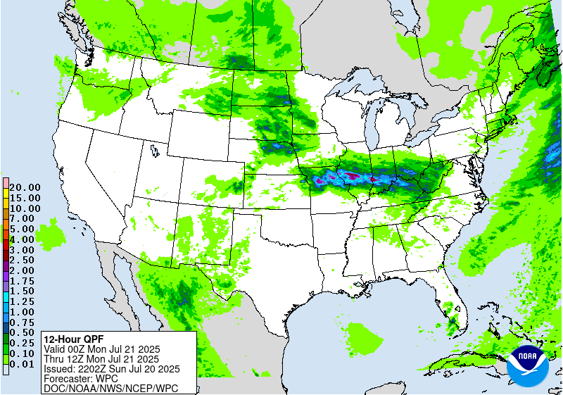
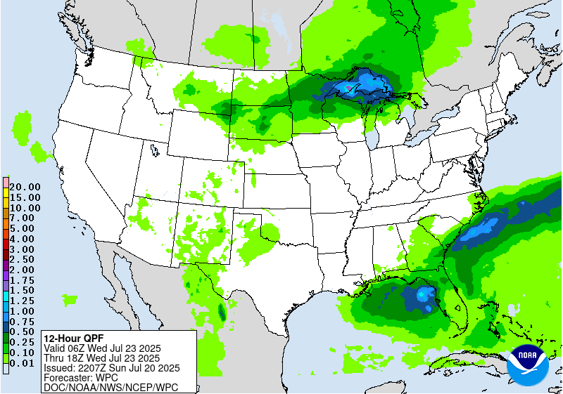
A quasi-stationary front extending from the Great Basin to the Northern
Plains and Middle Mississippi Valley remains quasi-stationary through
Tuesday evening. The eastern half of the front, extending from the
Mid-Atlantic to the Middle Mississippi Valley on Sunday, will move
southward to the Southeast and then extend northwestward to the Middle
Mississippi Valley by Tuesday evening. Moisture pooling along the front
over the Ohio Valley will produce showers and thunderstorms, accompanied
by heavy rain. Therefore, the WPC has issued a Moderate Risk (level 3/4)
of excessive rainfall over parts of the Ohio Valley through Monday
morning. Numerous flash flooding events are possible. Additionally, many
streams may flood, potentially impacting larger rivers.
Additionally, on Sunday, moisture just north of the front will produce
showers and thunderstorms, accompanied by heavy rain, over parts of the
Northern Plains. Therefore, the WPC has issued a Slight Risk (level 2/4)
of excessive rainfall with these thunderstorms over parts of the Northern
Plains through Monday morning. The associated heavy rain will primarily
create localized areas of flash flooding, with urban areas, roads, small
streams, and low-lying areas being the most vulnerable.
Additionally, on Sunday, showers and severe thunderstorms are expected to
develop over parts of the Northern/Central High Plains, along and north of
the front. Therefore, the SPC has issued a Slight Risk (level 2/5) of
severe thunderstorms over parts of the Northern/Central High Plains
through Monday morning. The hazards associated with these thunderstorms
are frequent lightning, severe thunderstorm wind gusts, hail, and a few
tornadoes. Moreover, there is an increased threat of hail two inches or
greater over the area. Additionally, Air Quality Alerts are in effect over
northern Minnesota due to wildfires in Canada from Sunday into Monday.
Furthermore, the cold front over the Northeast to the Central
Appalachians/Ohio Valley will produce two areas of showers and severe
thunderstorms. Therefore, the SPC has issued a Slight Risk (level 2/5) of
severe thunderstorms over parts of the Northeast and Central
Appalachians/Ohio Valley through Monday morning. The hazards associated
with these thunderstorms are frequent lightning, severe thunderstorm wind
gusts, hail, and a few tornadoes. The severe thunderstorms over the
Central Appalachians/Ohio Valley will have a minimal threat for hail. In
addition, showers and thunderstorms will develop over parts of the
Central/Southern Rockies, Central/Southern High Plains, and Southwest on
Sunday.
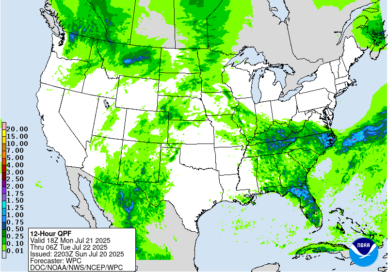
Moreover, on Monday, moisture will continue to pool along the front over
the Ohio/Tennessee Valleys, creating showers and thunderstorms. Heavy
rain will develop with the showers and thunderstorms over parts of the
Ohio/Tennessee Valleys, as well as the Central/Southern Appalachians.
Therefore, the WPC has issued a Slight Risk (level 2/4) of excessive
rainfall associated with these thunderstorms over parts of the
Ohio/Tennessee Valleys, as well as the Central/Southern Appalachians, from
Monday into Tuesday morning. The associated heavy rain will primarily
create localized areas of flash flooding, with urban areas, roads, small
streams, and low-lying areas being the most vulnerable.
Additionally, on Monday, the western end of the front will trigger showers
and severe thunderstorms over parts of the Northern High Plains.
Therefore, the SPC has issued a Slight Risk (level 2/5) of severe
thunderstorms over parts of the Northern High Plains from Monday into
Tuesday morning. The hazards associated with these thunderstorms are
frequent lightning, severe thunderstorm wind gusts, hail, and a few
tornadoes.
On Monday, showers and thunderstorms are expected to develop south of the
front, from the southern Mid-Atlantic to the Gulf Coast. Moreover, showers
and thunderstorms will develop near and along the front from the Northern
Plains/Upper Mississippi Valley. More showers and thunderstorms develop
along and near the front over the Southern High Plains, Central/Southern
Rockies, and Great Basin/Southwest. Showers and thunderstorms will also
develop in the moisture-rich air over the Southeast to the Central Gulf
Coast.
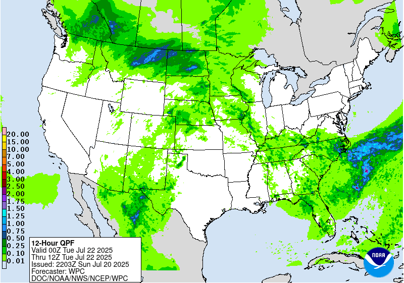
On Tuesday, strong to severe thunderstorms will develop near the front
over the Northern/Central Plains into the Upper Mississippi Valley.
Further, showers and thunderstorms with heavy rain will develop over parts
of the Upper Midwest. Therefore, the WPC has issued a Slight Risk (level
2/4) of excessive rainfall with these thunderstorms over parts of the
Upper Mississippi Valley and Upper Great Lakes on Tuesday. The associated
heavy rain will primarily create localized areas of flash flooding, with
urban areas, roads, small streams, and low-lying areas being the most
vulnerable.
Also on Tuesday, showers and thunderstorms will develop over parts of the
Southeast, the Central Gulf Coast, the Central/Southern High Plains, the
Central/Southern Rockies, and the Southwest.
Ziegenfelder
Graphics available at
https://www.wpc.ncep.noaa.gov/basicwx/basicwx_ndfd.php


