Station Plot


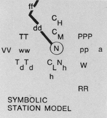
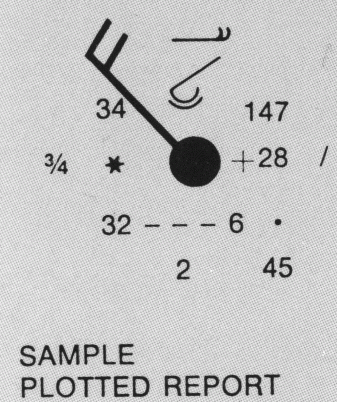
Weather information at a particular point is transmitted and plotted on a surface map at that stations location. The arrangement of the data around the station location is called a station model and is standardized by international agreement. Below is the station model showing the location of each piece of weather information along with an example station plot. Clicking on he location of the weather information will take you to an explanation of what that location represents a chart to decode the symbols.


This image displays the model used to plot weather at a station This image displays an example weather plot for a station
Sky Cover Wind Speed Pressure Tendency Present Weather Temperature Dew Point Visibility Sea Level Pressure Past Weather 6 Hour Precipitation High Cloud Type Middle Cloud Type Low Cloud Type Fractional Cloud Cover Height of Cloud Base Sky Cover Wind Speed & Direction Pressure Tendency Present Weather Temperature Dew Point Visibility Sea Level Pressure Past Weather 6 Hour Precipitation High Cloud Type Middle Cloud Type Low Cloud Type Fractional Cloud Cover Height of Cloud Base


Sky Cover | Wind Speed and Direction | Pressure Tendency | Present Weather | Temperature | Dew Point Temperature | Visibility | Sea Level Pressure | Past Weather | 6 Hour Precipitation | High Cloud Type | Medium Cloud Type | Low Cloud Type | Cloud Fraction | Cloud Base Height