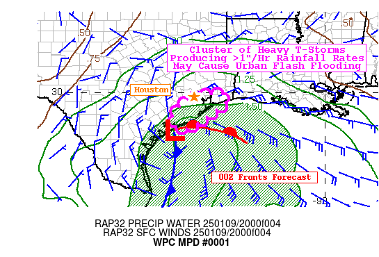
Mesoscale Precipitation Discussion 0001
NWS Weather Prediction Center College Park MD
454 PM EST Thu Jan 09 2025

Areas affected...Upper Texas Coast

Concerning...Heavy rainfall...Flash flooding possible

Valid 092200Z - 100400Z

SUMMARY...Blossoming convection may briefly train along portions
of the Upper Texas coast this evening. Rainfall rates around
1.5"/hr are possible in urbanized communities and could lead to
localized flash flooding in poor drainage areas.

DISCUSSION...Deepening low pressure along the Texas coast is
located beneath the divergent right-entrance region of a robust
~160kt 250mb jet streak over the Middle Mississippi River Valley
this afternoon. Farther west, an anomalous upper trough over
northern Mexico contains 500mb heights as low as the 1st
climatological percentile according the NAEFS. Onshore flow will
increase at low levels this evening as high pressure over the Ohio
Valley and the deepening surface low along the Texas Coast tighten
the surface pressure gradient. In fact, southerly 850mb winds of
40-50kts around 00Z this evening are above the 99.5 climatological
percentile per NAEFS. These atmospheric parameters are playing a
role in the development of an IVT surpassing 1,000 kg/m/s, which
are values above the maximum observed IVT levels in the CFSR
database per NAEFS.

As the low-level wind field strengthens, surface-925mb FGEN will
also strengthen as low-level winds draw PWs up to 1.75" ahead of
the storm. Rainfall rates will increase in intensity this evening
to the north of the warm front, as well as the western flank of
the storm's circulation. Area averaged HRRR soundings from the
Houston metroplex to Galveston show >98% saturated soundings from
the surface to 300mb and warm cloud layers as deep as 12,000ft.
This supports favorable warm rainfall processes, but the one big
ingredient that is lacking is instability. Moisture advection and
synoptic-to-mesoscale forcing alone would support hourly rainfall
rates of 1"/hr rainfall rates, but the HRRR shows as much as 250
J/kg of MUCAPE present along the Upper Texas coast. It is here
where hourly rainfall rates may approach 1.5"/hr with low chances
(5-10% via the 12Z HREF) for rainfall rates of >2"/hr.

NASA SPoRT-LIS in the sfc-10cm and sfc-40cm soil depths are
running drier than normal with some locations in moderate drought
according to the latest drought monitor. This atmospheric setup is
one where most of the observed rainfall will be more beneficial
than harmful. That said, locally excessive rainfall rates may lead
to localized flash flooding tonight in areas that feature a
greater concentration of non-permeable surfaces. Any minor
flooding or ponding may also be harder to identify for motorists
with the heaviest rainfall rates arriving after sundown.

Mullinax

ATTN...WFO...HGX...LCH...

ATTN...RFC...WGRFC...NWC...

LAT...LON   29949414 29599410 29139464 28519559 28559607
            28819626 29089625 29489589 29849525
Download in GIS format: Shapefile
| KML
Last Updated: 454 PM EST Thu Jan 09 2025
