Mesoscale Precipitation Discussion 0002
NWS Weather Prediction Center College Park MD
1228 AM EST Mon Jan 13 2025

Areas affected...southeastern Louisiana into southern Mississippi
and southwestern Alabama

Concerning...Heavy rainfall...Flash flooding possible

Valid 130527Z - 131027Z

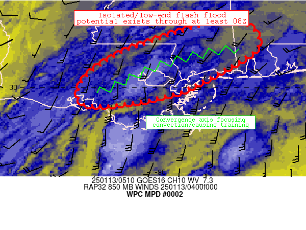
Summary...Isolated/low-end flash flood potential exists as shallow
convection continues to redevelop/train across the discussion
area.

Discussion...Over the past 2-4 hours, a focused area of convection
has trained along an axis extending from near Morgan City to near
Laplace and Lake Pontchartrain.  The convection is favorably
oriented parallel to fast (60-80 kt) southwesterly flow aloft and
is also being maintained by focused convergence on the nose of
30-kt 850mb flow.  Stout convergence is maintaining this
convection despite modest instability.  Training convection was
resulting in a few spots of 0.5-1 inch/hr rain rates that have
persisted long enough for MRMS rainfall estimates exceeding 3
inches per six-hours.  MRMS also depicts peak rainfall/FFG ratios
now exceeding 0.6 in spots beneath the training band.

Also somewhat concerning is the fact that models/CAMs suggest that
the sustained convergence resulting in the convection should
persist across areas west of New Orleans for at least another
couple hours, further contributing to localized runoff/flood
potential especially in western suburbs of New Orleans Metro.
Over time, the axis of heavier rainfall should translate eastward
in tandem with peak 850mb flow, with a few spots of isolated
flood/runoff problems extending toward Northshore Lake
Pontchartrain and adjacent areas of southern
Mississippi/southwestern Alabama over the next 2-4 hours or so.
This threat should remain isolated, but may become enhanced where
heavier rain rates can affect any urban/low-lying areas.

Cook

ATTN...WFO...JAN...LCH...LIX...MOB...

ATTN...RFC...LMRFC...SERFC...NWC...

LAT...LON   31418904 31418809 30988783 30648822 30028936
            29888975 29659086 29649184 30129186 30689116
            31089015
Download in GIS format: Shapefile
| KML
Last Updated: 1228 AM EST Mon Jan 13 2025
