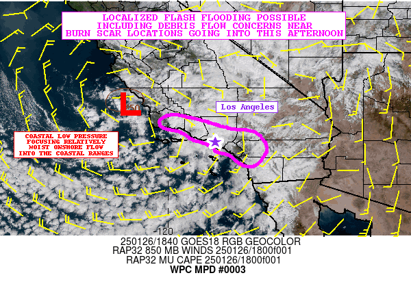
Mesoscale Precipitation Discussion 0003
NWS Weather Prediction Center College Park MD
205 PM EST Sun Jan 26 2025

Areas affected...Southern California

Concerning...Heavy rainfall...Flash flooding possible

Valid 261905Z - 270105Z

SUMMARY...Locally heavy showers and a few thunderstorms arriving
over the next several hours may result in localized areas of burn
scar flash flooding, including debris flow activity. This will
include the Eaton, Palisades, Hurst, Franklin, Bridge and Hughes
fire areas.

DISCUSSION...GOES-W satellite imagery shows an upper-level low
continuing to drop south toward southern CA, with coastal surface
low pressure helping to facilitate an increase in low-level
onshore flow into the Transverse and Peninsular Ranges. The flow
is modest, but the uptick in Pacific moisture coupled with
gradually steepening mid-level lapse rates and divergent flow
aloft via DPVA is driving broken coverage of moderate to locally
heavy shower activity.

Additional shortwave energy rounding the base of the upper low
will overspread the coastal ranges this afternoon, including much
of the broader Los Angeles Basin. This coupled with a slight
increase in diurnally driven instability and orographic ascent
should help facilitate an increase in rainfall rates. In fact,
there has already been some lightning activity noted with recent
low-topped convection that has impacted Ventura County, and radar
imagery shows convection tending to intensify just offshore of Los
Angeles County which will be moving inland soon. This is where
some MUCAPE values of 250+ J/kg are noted in the latest RAP
analysis.

The 12Z HREF guidance favors occasional rainfall rates locally
reaching or exceeding a 0.25"/hour with some of the stronger
convective elements that materialize over the next several hours.
However, with the slight increase in instability and pulse nature
of the convective threat, it is possible that there could be as
much as a 0.25" of rain in as little as 15 to 30 minutes. The
latest guidance suggests some spotty 6-hour rainfall totals
reaching upwards of 1 inch where some of this activity persists
over the foothills of the terrain including the San Gabriel and
San Bernadino Mountains.

Given the significant sensitivities on the ground with the ongoing
wildfire activity and/or recently burned areas, these rains may be
sufficiently heavy enough, at least on a localized basis, to
result in some debris flow/mudslide activity and related flash
flooding concerns. The Eaton, Palisades, Hurst, Franklin, Bridge
and Hughes burn scar areas in particular will need to be closely
monitored for impacts.

Orrison

ATTN...WFO...LOX...SGX...

ATTN...RFC...CNRFC...NWC...

LAT...LON   34861989 34761923 34681885 34521836 34381780
            34271702 33761663 33271688 33101720 33241756
            33491792 33601830 33841860 34041918 34291960
            34422014 34662028
Download in GIS format: Shapefile
| KML
Last Updated: 205 PM EST Sun Jan 26 2025
