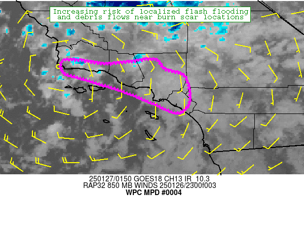
Mesoscale Precipitation Discussion 0004
NWS Weather Prediction Center College Park MD
906 PM EST Sun Jan 26 2025

Areas affected...Southern California

Concerning...Heavy rainfall...Flash flooding possible

Valid 270205Z - 270805Z

SUMMARY...An uptick in shower and thunderstorm activity is
expected through the evening hours across coastal portions of
southern California. This may result in localized areas of burn
scar flash flooding, including debris flow activity. This will
include the Eaton, Palisades, Hurst, Franklin, Bridge and Hughes
fire areas.

DISCUSSION...GOES-W satellite imagery continues to show a deep
layered low dropping south just off the southern CA coast. Some
cooling of cloud tops is noted over coastal Santa Barbara county,
resulting in a modest uptick in rainfall rates. As of 01z, water
vapor imagery continues to depict mid and upper level dry air
further south over Los Angeles county, likely helping limit shower
coverage and intensity. However, as the low continues to drop
south, we should see a gradual moistening of the column, along
with a steepening of lapse rates. These factors should promote an
uptick in shower (and isolated thunderstorm) activity over coastal
areas of Ventura, Los Angeles and Orange counties as the evening
progresses. In fact as of 02z just beginning to see an uptick in
shower activity and slight cooling in IR imagery over Los Angeles
County.

Recent HRRR runs and the 18z HREF are supportive of an uptick in
shower coverage and rainfall rates between 02z and 12z. HREF
probabilities of exceeding 0.5" in an hour increase into the
20-40% range. The 23z HRRR depicted hourly rainfall around 0.75"
just offshore, although the 00z HRRR is back closer to 0.5" an
hour for peak rates. Both the HREF and HRRR focus the majority of
these higher rates just offshore where the weak instability should
stay focused. However, while the better coverage of these higher
rates should remain just offshore, do anticipate we will see some
0.5"-0.6" an hour rainfall make it onshore on a localized basis
anytime between ~02z and 12z.

For the most part this forecast rainfall will only result in
localized minor flooding of urban and low lying areas. However,
more significant impacts are possible over recent burn scar areas,
particularly over Los Angeles County. Confidence on these more
significant impacts remains low, however with the expected uptick
in shower coverage and intensity this evening, the threat of
significant impacts is higher than it was earlier this afternoon.
The Eaton, Palisades, Hurst, Franklin, Bridge and Hughes burn scar
areas in particular will need to be closely monitored for debris
flow impacts this evening into the overnight hours.

Chenard

ATTN...WFO...LOX...SGX...

ATTN...RFC...CNRFC...NWC...

LAT...LON   34651835 34431817 34301774 33981760 33631762
            33451786 33571821 33631832 33991925 34322034
            34382049 34642044 34551947 34561934 34611884
Download in GIS format: Shapefile
| KML
Last Updated: 906 PM EST Sun Jan 26 2025
